Download
1 / 46
460 likes | 684 Views
How long does it take for the Earth to complete its orbit around the sun? 365 days 28.5 days 365.2425 days 30 days. Soil is the living skin of the Earth. Midwestern soils are among the most fertile in the world. 2. 800-year-old dune sand. modern soil. 800-year-old buried soil. 3.

E N D
How long does it take for the Earth to complete its orbit • around the sun? • 365 days • 28.5 days • 365.2425 days • 30 days
Soil is the living skin of the Earth. Midwestern soils are among the most fertile in the world. 2
800-year-old dune sand modern soil 800-year-old buried soil 3
800-year-old dune sand modern soil 800-year-old paleosol 4
With bad farming or grazing practices, nutrient levels that built up over millenia can be depleted in decades. Dallas, SD; 1936 They’re making more people every day, but they ain’t makin’ any more dirt --Will Rogers 5
Problems with Too Many Nutrients: Great quantities of artificial fertilizers are now being added to soils in the Corn Belt. An oversupply of nutrients to a lake or bay causes algae to flourish. An oxygen shortage takes place when the algae decompose and circulation of the water slows, killing fish and large invertebrates. Over-application of fertilizer to surrounding fields and the growing number of septic systems along lake shores are the main causes for nutrient oversupply. 6
A “dead zone” is commonly present at the mouth of the Mississippi, caused largely by runoff from over-fertilized Midwestern croplands. 7
Caliche (calcite that accumulates in the soil zone) High Plains surface, New Mexico 9
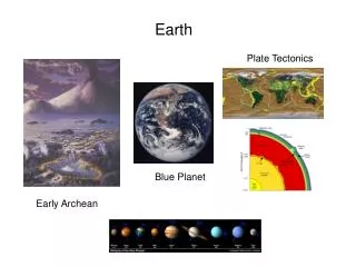
Today and Friday lectures-- Plate Tectonics (Chapter 17) paradigm = dominant model; for example, plate tectonics, or quantum mechanics
“The Origin of the Continents and Oceans” Alfred Wegener, 1915 11
marsupial “wolf” Australia’s diverse marsupial mammal fauna is a direct result of evolution during the continent’s long geographic isolation. 13
Africa, too, became isolated when Gondwana broke up. The latest information from DNA studies indicates this group of mammals evolved in isolation on Africa. Late Mesozoic 85 million years ago Representatives of the six orders of mammals comprising the Superorder Afrotheria: (Upper Left) African forest elephant; (Upper Right) Golden-rumped elephant shrew; (Middle Left) Aardvark; (Middle Right) Streaked tenrec; (Lower Left) Eastern tree hyrax; and (Lower Right) Dugong (Dugong dugon). 14
The Emu, Rhea, Cassowary, and Ostrich share a Gondwandan ancestry 15
Fossils: Wegener’s ideas explained the distribution of fossils very, very well, but his idea was rejected anyway. 16
Former position of Africa 17
“Jig-saw Fit” Wegener called attention to the “jig-saw fit” of continents and explained it. His idea was rejected anyway. 19
Karoo Basin, South Africa Observation:Unsorted clastic sedimentary rocks resting on striated (scratched and scraped) nonconformity. Interpretation:Ancient glaciation 20
Ancient Climates Wegener’s idea explained the distribution of different climate-sensitive sedimentary rocks very, very well, but his idea was rejected anyway. 23
Ancient Climates Wegener’s idea explained the distribution of different climate-sensitive sedimentary rocks very, very well, but his idea was rejected anyway. Why the rejections??? 24
A new look at an old planet: Technology developed during WWII allowed mapping of the seafloor and led to new discov- eries concerning the magnetic properties of rocks. This (finally) led to a new appreciation of Wegener’s idea. 25
Magnetic properties of the Pacific seafloor off the coast of U.S. and Canada (left) and the Atlantic seafloor SW of Iceland (below) On each map, note that half the seafloor is mapped black (“strongly magnetized”, half is mapped white (“weakly magnetized”): Weird. 26
Apparent Polar Wander 31 Polar wander curves for North America and Europe
Why is it called apparent polar wander? • Because it only appears that magnetic poles have wandered. • Because it is obvious magnetic poles have wandered. • Because basalt is the only rock that records the planet’s magnetic polarity.
If the above hypothesis for the origin of the Earth’s magnetic field is correct, no way each continent could have its own polar wander path! Conclusion: Continents wander, not poles. 33
Geographies older than 150 million years are more difficult to reconstruct than those younger than 150 million. 34
Magnetic Reversals Recorded by Lava Flows 1963 1964a 1964b 1966a 1966b 0 Age in millions of yrs 1 2 3 Black=normal White=reversed 35
Magnetic properties of the Pacific seafloor off the coast of U.S. and Canada (left) and the Atlantic seafloor SW of Iceland (below) Maybe the “strongly magnetized” rocks have normal polarity and the “weakly magnetized” rocks have reversed. 36
Magnetic Reversals Recorded by Lava Flows 1963 1964a 1964b 1966a 1966b 0 Age in millions of yrs 1 2 3 Black=normal White=reversed 37
Magnetic properties of the Pacific seafloor off the coast of U.S. and Canada (left) and the Atlantic seafloor SW of Iceland (below) Note the “mirror image” aspect of these patterns 39
The idea of seafloor spreading was born in 1963. Land-based record of reversals
The black stripes are from basalt that formed under a normal magnetic field; the white under a reversed field. The 50:50 areal distribution, and the “mirror image” aspect confirm the idea of seafloor spreading. 43
The mirror image aspect of the seafloor coincides with the vertical stack of volcanic rocks on Hawaii. 44
Jaramillo Event observed computed
Jaramillo Event observed computed