Download
1 / 10
100 likes | 220 Views
Update on DOT Nationwide Differential GPS (NDGPS) Program. Presentation to : National Space-Based Positioning, Navigation and Timing Advisory Board Doubletree Hotel Washington, DC Timothy A. Klein Senior Policy Advisor/RITA NDGPS Coordinator NDGPS@dot.gov. What is NDGPS?.

E N D
Update on DOT Nationwide Differential GPS (NDGPS) Program Presentation to: National Space-Based Positioning, Navigation and Timing Advisory Board Doubletree Hotel Washington, DC Timothy A. Klein Senior Policy Advisor/RITA NDGPS Coordinator NDGPS@dot.gov
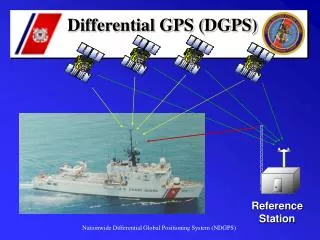
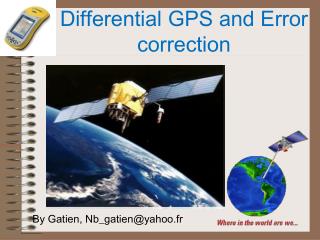
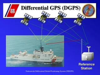
What is NDGPS? • Nationwide Differential GPS • Augmentation system composed of: • USGC/Maritime DGPS for Harbor/Entry Approach → 39 sites • USACE Sites for Inland Waterways → 9 sites • DOT/Inland NDGPS for Terrestrial Applications → 38 sites • IOC = Single coverage over CONUS • FOC = Dual coverage over CONUS • Inland NDGPS currently 8 sites short of IOC
NDGPS System Characteristics • Accuracy • 1 – 3 meters at up to 150 km (10 m requirement) • 0.5 meter near the reference station • 5 cm with post-processing (CORS) • Many field users report better results • Integrity • 5 seconds at 100 bps • 2.5 seconds at 200 bps • Designed for Use in Impeded Environments
NDGPS Services • NDGPS Provides to Multiple User Communities: • Sub-meter accuracy in multiple terrestrial applications • Accurate real-time positioning in all surface environments, including impeded environments (mountains, valleys, tunnels, urban canyons) • Post-processed data for increased accuracy for resource management and mapping
NDGPS Partnerships • Partners Currently Relying on NDGPS Data • National and Cooperative Continuously Operating Reference Stations (CORS) • Robust backbone stations for CORS • Post-processing for repeatable survey, mapping, and resource management applications. • National Oceanic and Atmospheric Admin. • National Weather Service/Water Vapor • Space Weather Prediction Center • UNAVCO Tectonic Plate Monitoring
National Space-Based PNT ExecCom Action • Action: DOT complete assessment of the need for inland component of NDGPS • Final resolution of to be determined by: • interagency requirements • level of support • If no transportation requirements or other Federal user requirements, DOT intends to develop decommissioning plan for NDGPS • DOT cost share with other agencies possible if there is a transportation requirement • Due date: January 30, 2008
Assessment Activities • Federal Register Notice (Closed 10/1/07) • Seeks requirements for continuing current inland NDGPS operations, completing NDGPS IOC or FOC • Seeks funding partnerships • States that if further investment not in public interest, DOT will plan decommissioning • Letters to Federal Agencies (In Work) • Seeks mission requirements for NDGPS • Seeks funding sponsorship • Independent Assessment (ARINC) • Assess private sector/commercial requirements • Assess economic impacts
NDGPS Funding • DOT FY08 Funding = $5M • Included in President’s request for DOT and in both Appropriations bills • Existing NDGPS maintenance and operations only; no construction/upgrade for sites • DOT FY09 Funding = ??? • If DOT does not fund inland NDGPS in FY09, USCG has identified 12 DOT Funded Sites to preserve Maritime coverage. • No matter the outcome for inland NDGPS, USCG will continue to operate and maintain Maritime DGPS
Current Maritime + Inland NDGPS Coverage Approximately 92% of the lower 48 states has single coverage and 65% has dual coverage.