1 / 0

Exam tips

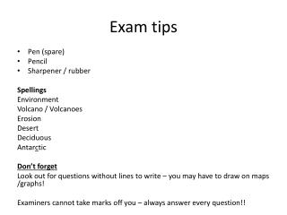
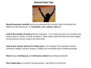
Exam tips. Pen (spare) Pencil Sharpener / rubber Spellings Environment Volcano / Volcanoes Erosion Desert Deciduous Don’t forget Look out for questions without lines to write – you may have to draw on maps /graphs! Examiners cannot take marks off you – always answer the Q!!.

durin
Download Presentation

Exam tips

An Image/Link below is provided (as is) to download presentation Download Policy: Content on the Website is provided to you AS IS for your information and personal use and may not be sold / licensed / shared on other websites without getting consent from its author. Content is provided to you AS IS for your information and personal use only. Download presentation by click this link. While downloading, if for some reason you are not able to download a presentation, the publisher may have deleted the file from their server. During download, if you can't get a presentation, the file might be deleted by the publisher.

E N D

Presentation Transcript


  1. Exam tips Pen (spare) Pencil Sharpener / rubber Spellings Environment Volcano / Volcanoes Erosion Desert Deciduous Don’t forget Look out for questions without lines to write – you may have to draw on maps /graphs! Examiners cannot take marks off you – always answer the Q!!
  2. GEOGRAPHY UNIT 1 UNIT 2 Population Change Changing Urban Environments Tourism Restless Earth Living World Water On the Land
  3. Three questions! Restless Earth Living World Water on the land
  4. Destructive? Constructive? Conservative?
  5. Describe the distribution of Volcanoes
  6. Convection currents in the mantle drive the plates to move!!
  7. Destructive Convection currents Move together Subducted Friction = earthquake Melted plate = pressure = volcano
  8. Constructive Convection currents Plates move apart Magma rises Lava spreads out at surface Creates a shield volcano
  9. Conservative Convection currents Plates move alongside each other Friction causes pressure to build up As plates jolt pressure is released as seismic waves = earthquake
  10. Volcanoes
  11. Mt St Helens
  12. Monitoring and Predicting Volcanoes Tiltmeters Gas Sensors GPS Seismographs Thermometers (ground and water temperatures) Animal behaviour Think about how you know you have a tummy upset! 
  13. Formation of a supervolcano Think of a big spot!
  14. Supervolcano – Yellowstone, USA Size / Shape Effects An eruption today would have a catastrophic effect. It is potentially five times the minimum size for a supervolcanic eruption by the size of the magma chamber. An eruption is likely to destroy 10,000 km2 of land and kill 87000 people. 1 in 3 people will be killed within 1000km of an eruption. 15cm of ash would cover buildings within this area and make them collapse. This ash would ground planes and make road transport difficult. Livestock would die as they would choke in the hot ash. UK would see the arrival of the ash about 5 days later. This ash will circle the Earth, changing the climate. Temperatures will fall by over 10 degrees which will make it difficult to grow food in many areas. 40% of the population could face starvation. Certain parts of northern Europe will be snow covered for 3 years, so no food will be able to be grown. 1000km3 The magma chamber beneath Yellowstone is believed to be 80km long, 40km wide and 8km deep Caldera – large depression surrounded by a raised rim
  15. Fold Mountains
  16. Fold Mountains

    Challenges: Steep Relief – Use of chairlifts to travel up slopes and get fresh produce (milk) from farms down to market. Use of steep slopes for tourism e.g. skiing. Poor Soils – Use of fertilisers and farming on flat valley floor Limited Communications – New roads, railway lines (on flat valley floors) and tunnels e.g. Mont Blanc and St. Bernard tunnels. Uses HEP – generates energy for local villages (ideal snow melt in summer provides water, easy to build dam across valley) Farming - Transhumance farming Tourism – Winter (skiing) Summer (mountain biking / hiking) Industries – saw mills (wood), electrochemical, mining
  17. GeosynclineSedimentary rock – sandstoneCompressed to form fold mountains e.g. Alps
  18. Describing the distribution of ocean trenches and fold mountains Edge of oceans – Pacific Ocean Where continental and oceanic plates meet Fold mountains – west coast of North and South America ** use names
  19. Earthquakes
  20. Keywords: Focus Epicentre Seismic wave
  21. How we measure earthquakes What are the differences?
  22. Monitoring and Predicting Earthquakes Three Ps Prediction – attempts to forecast when it will happen Protection – construction of buildings so they are safe and will not collapse Preparation – organising activitiesand drills so people know what to do in the event of and earthquake
  23. Tsunami
  24. Tsunami The Indo Australian plate subducts beneath the Eurasian plate causing an earthquake. The earthquake displaces the column of water above it upwards. The water that has gone up comes down and splits into two waves. One wave travels out to sea and the other wave travels towards the coastal areas of south-east Asia. The wave reaches the shoreline and gains height before it crashes onto the land. Primary cause = the earthquake Secondary cause = the Tsunami wave
  25. Tsunami – Indian Ocean, Boxing Day, 2004
  26. Living World
  27. Ecosystem A community of living (animals and vegetation) and non living components (soil and climate) and the relationships that exist between them
  28. Climate 1 5 Animals Soil 3 4 2 Vegetation
  29. Producer – organisms that obtain their energy from a primary source such as the sun Consumer – organisms that obtain their energy by eating other organisms Food Chain – a line of links between producers and consumers Food Web – a diagram showing the complex links between producers and consumers
  30. Do you know the difference? Decomposer Organisms such as bacteria that break down plant and animal material. Scavenger Organisms that consume dead animals or plants
  31. Biome Micro Meso Macro Biome – global scale ecosystem dominated by climate e.g. Tropical Rainforest.
  32. Location /Distribution Tropical Rainforests – along the equator (Between the tropic of Cancer and Capricorn) Deserts – 15-30 degrees North and South Temperate Deciduous Forests 40-60 degrees North and south
  33. Biome Case studies
  34. Climates and Soils
  35. Climate graphs If you have to describe them include numbers! Highest Lowest Seasons
  36. Stratified Vegetation growing in layers Tropical Rainforest Deciduous Woodland
  37. Vegetation Adaptations
  38. Tropical Rainforest
  39. Causes and impacts of deforestion
  40. Sustainable management in the Tropical Rainforest
  41. Deciduous Woodland
  42. Recreation – interpreting a map Use the key to suggest recreational activities that may take place in this ecosystem
  43. Sustainable management in Deciduous Woodland (Epping Forest – Essex)
  44. Deserts
  45. Economic opportunities, challenges and management MEDC/RICH DESERTSONORAN DESERT, USA
  46. Economic opportunities, challenges and management LEDC/POOR DESERTTHAR DESERT, INDIA
  47. Sustainable Management Protected for future generations Describe the strategy but also link this to how this leads to protecting the environment for future generations to use
  48. Water on the land
  49. River Profile
  50. Landforms ‘V-shaped Valley’ Vertical erosion Weathering V shaped Valley
  51. Landforms ‘Waterfall’ Resistant and less resistant rock Soft rock is eroded by (describe processes) Undercuts hard rock Hard rock collapses into plunge pool Forms a steep sided gorge
  52. Landforms ‘Meander and Oxbow Lake’ Lateral erosion on the outside of the bend because of Hydraulic action… (describe erosion processes) Deposition on the inside of the bend where there is less energy. Neck narrows over time Flood event / high discharge breaks through neck Forms an Oxbow lake Cross Section Make sure you label the inside and outside!
  53. Landforms ‘Floodplain’ Meander erodes a flat valley floor either side of the river channel. Deposits alluvial sediments – larger near river channel Leaves layers of flat fertile land with raised levees either side of channel
  54. Flooding Discharge Lag time Interception Infiltration Percolation Permeable/impermeable
  55. Discharge:
  56. Frequency and location of flooding in the UK More frequent March 1947 – Major floods January 1953 1968 – Great Flood (South East England) Gap 1998 onwards – annual occurrence
  57. Flooding – MEDC/RICH Boscastle 2004
  58. Flooding – LEDC/POOR Bangladesh 2004
  59. Differences between rich and poor Effects Responses
  60. Flood Prevention
  61. Case studies – Hard Engineering. China, Three Gorges Dam
  62. Soft engineering Environment agency Flood Warning systems Send texts direct to registered users Flood watch and then flood warning Website Information about how to prepare for a flood.
  63. Flood Transfer Scheme Water Surplus Water Stress Water deficit
  64. Case study = Kielder Water in Northumberland
  65. MAP SKILLS
  66. Maps Choropleth Topological Physical
  67. Compass rose How can we remember the points of the compass? ‘Never eat shredded wheat!’ Now think of your own slogan.
  68. 4-figure grid references
  69. 6-figure grid references
  70. 6-figure grid references
  71. Scale
More Related