Download

1 / 27
270 likes | 446 Views
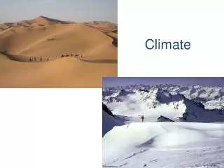
Climate!. How is Climate different than Weather?. What Factors Affect the Climate of a Region?. List here…. Orographic Effects. Orographic Effects –windward and leeward side of mountain ranges have different climates

E N D
What Factors Affect the Climate of a Region? • List here…
Orographic Effects • Orographic Effects –windward and leeward side of mountain ranges have different climates • Why? Air mass rises and cools adiabatically (without any energy input), clouds form, and thus it rains. Air cools due to expansion…as it comes down the other side, warms adiabatically due to compression and dries out. • Rate of cooling is known as the lapse rate
Ocean Currents • Stream of water consisting of the same temperatures, circulating throughout the ocean basin • Warm currents- warm air above, bring warm weather • Cool currents- cool air above, bring cool weather • See esrt p4
Winds Planetary Winds caused by the Coriolis Effect See Esrt p14 Monsoon- period of severe rains, occurs in Southern Asia, are the resulting of shifting winds. Warming summer continent causes winds to blow from sea inland instead of out to sea.
El Nino, La Nina • Predictable Weather Events resulting from movement of ocean currents and winds off the coast of South America and North America • El Nino- warming event-warm mass of ocea water moves and spreads eastward along the coast of South America. Brings with it warm air, full of thunderstorm capability and severe rains.
Continued… • These disturbances offset the Jet Stream and thus global weather patterns • Results in warmer, wet winters for the US and places like India and Australia dry out. • La Nina results in the opposite effect
http://esminfo.prenhall.com/science/geoanimations/animations/26_NinoNina.htmlhttp://esminfo.prenhall.com/science/geoanimations/animations/26_NinoNina.html On click El Nino Animation
Storm Tracks • Storms move west to east with the prevailing winds • Hurricanes typically move west off the coast of Africa ,then north to north east • This is the path of a storm
Latitude and Elevation • As the distance from the equator increases, the temperature of a location decreases • See same effect as elevation increases ( mountains) • Climatographs show temperature and precipitation for a particular location. Warmest temperatures are in the summer months in the northern hemisphere and coldest in the summer months for the southern hemisphere • P/Ep ratio also classifies climate in terms of arid vs humid (over 1.2 is humid, and under 0.4 is arid)