Download
1 / 1
10 likes | 69 Views
1. What are MassGIS Web Mapping Services?.

E N D
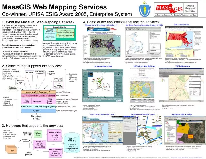
1. What are MassGIS Web Mapping Services? • The MassGIS Web Mapping Services were developed as part of a Massachusetts Information Technology Division E-Government initiative started in March 2001. The web mapping services were envisioned as one of four common, statewide “shared services”. (web mapping, customer relations management, credit card payments, security) • MassGIS takes care of these details so government entities don’t have to: • -Purchase of servers, bandwidth • Purchase, installation and configuration of software (database, web mapping, web serving) • Loading GIS data and keeping it up-to-date. Agencies don’t need to spend time, money or staff on these functions. Their programmers can focus on developing an application (in any programming language with XML support) and include maps. The services currently receive an average of 75,000 requests per day. MassGIS Web Mapping Services Co-winner, URISA ESIG Award 2005, Enterprise System 4. Some of the applications that use the services: DCR Forestry Viewer Massachusetts Broadband Institute Survey MA Ocean Resource Information System (MORIS) Purpose: Collects and maps type of Internet access Agency: Massachusetts Broadband Institute Languages: Google maps + WMS, php http://www.massbroadband.org/mapping/survey.html Purpose: Offers CZM + MassGIS data catalogs, geocoding, data extract Agency: Massachusetts Coastal Zone Management Languages: Java http://www.mass.gov/czm/mapping/index.htm Purpose:Show forestry information by town Agency:MassachusettsDepartment of Conservation and Recreation Languages:OpenLayers http://maps.massgis.state.ma.us/dcr/forestry/forestry23.html 2. Software that supports the services: DOE Schools Near Me Viewer VoIP Editing Viewer The National Map, USGS Developers are free to use each symbolized layer (theme) independently in applications (GeoServer) maps (ArcGIS Server) VoIP Viewer Real Property Viewer (JSP) ArcMap OpenSpace Editing Examples of some applications that use the services OLIVER Census 2000 Viewer (JSP) DEP WIRE Viewer (OpenLayers) Coastline Change Viewer (JSP) Legislative Viewer (JSP) Apache Web Server or IIS serves HTML, images JBoss Application Server or Tomcat runs applications MassGIS buys, installs, maintains data and software stack creates map images from data answers queries address matches ESRI ArcIMS GeoServer ESRI ArcGIS Server Purpose: Allow users to add sites, change status of VoIP sites Agency: ITD Languages: .NET ADF Purpose: Finds nearest schools Agency: Massachusetts Department of Education Languages: .NET http://profiles.doe.mass.edu/search/get_closest_orgs.aspx Purpose: National portal for data Agency: US Geological Survey Languages: Javascript http://nmviewogc.cr.usgs.gov/ ESRI Spatial Database Engine (SDE) spatial connection to Oracle Oracle stores data in seamless layers Real Property Sales (LA3) Viewer MA Historic Commission Viewer OpenSpace Editing Toolbar Datalayers, Images 3. Hardware that supports the services: MassGIS buys, installs, maintains servers, networking, and bandwidth GeoServer 2.0.3 1 core 4 GB RAM cluster 2 Linux WMS maps WFS info HAProxy Linux SDE 10 Oracle 11.2 48 GB RAM 8 cores 1000+ Datalayers 7.4 terabyte Linux Internet connection ArcIMS 10 2 cores 2 GB RAM Windows 2008 Purpose: Distributes building sales data in map format Agency: Massachusetts Department of Revenue Languages: JSP, Java Beans http://maps.massgis.state.ma.us/LA3/pages/main.jsp Purpose: Display historic properties and districts Agency: MA Historic Commission Languages: OpenLayers (not yet released) Purpose: Allows ArcMap users to download, edit, upload openspace Agency: Environmental Affairs, working with towns, land trusts Languages: .NET, uses GeoServer apps ArcIMS 9.2 2 CPUs 1.13 GHz 4 GB RAM Windows 2000 ArcGIS Server 10 6 cores 18 GB RAM Windows 2008 maps geocodes 12/15/11 Aleda.Freeman@state.ma.us, Gabriela.Laird@state.ma.usV:\MgisProjRes\Projects\ArcIMS_Web_Services\Statistics\web_mapping_services_poster.ppt http://maps.massgis.state.ma.us/temp/web_mapping_services_poster.ppt http://www.mass.gov/mgis https://wiki.state.ma.us/confluence/display/massgis