Download
1 / 2
20 likes | 159 Views
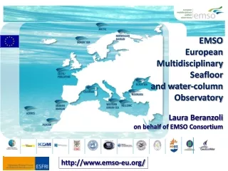
Arctic. Norwegian Margin. Nordic Sea. Porcupine. Black Sea. Ligurian Sea. Azores. Marmara. Eastern Sicily. Iberian Margin. Hellenic. Seafloor observatory network in the world. MACHO (Taiwan). EMSO European Multidisciplinary Seafloor Observatory

E N D
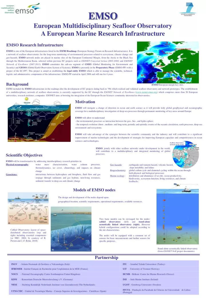
Arctic Norwegian Margin Nordic Sea Porcupine Black Sea Ligurian Sea Azores Marmara Eastern Sicily Iberian Margin Hellenic Seafloor observatory network in the world MACHO (Taiwan) EMSO European Multidisciplinary Seafloor Observatory A European Marine Research Infrastructure EMSO Research Infrastructure EMSO is one of the European infrastructures listed in the ESFRIRoadmap (European Strategy Forum on Research Infrastructures). It is a network of seafloor observatories for the long-term monitoring of environmental processes related to ecosystems, climate change and geo-hazards. EMSO networknodes are placed in marine sites of the European Continental Margin, from the Arctic to the Black Sea through the Mediterranean Basin, selected within previous EC projects such as ESONET Concerted Action (2002-2004) and ESONET Network of Excellence (2007-2011). EMSO constitutes the sub-sea segment of GMES (Global Monitoring for Environment and Security) and GEOSS (Global Earth Observation System of Systems). EMSO is presently in the Preparatory Phase (EMSO-PP) with a project of the EC-FP7. This project is aimed at establishing the legal entityEMSO which is able to manage the scientific, technical, logistic and administrative components of the infrastructure. EMSO-PP started in April 2008 and will run for 4 years. Background ESFRI included the EMSO infrastructure in the roadmap after the development of EC projects dating back to ’90s which realised and validated seafloor observatory and network prototypes. The establishment of a multidisciplinary network of seafloor observatories is currently supported by the EC through the ESONET Network of Excellence (www.esonet-emso.org) which comprises more than 50 European universities, research institutes, companies. ESONET aims at boosting the integration of the European Ocean Sciences community interested in observatories. EMSO European margin key sites. • Motivation • EMSO will instigate a change of direction in ocean and earth science as it will provide truly global geophysical and oceanographic coverage for a multidisciplinary investigation of deep-sea processes through permanent monitoring of key areas around Europe. • EMSO will allow to understand • the environmental processes as interaction between the geo-, bio-, and hydro-sphere; • the temporal evolution (short-, medium- and long-term, periodic and episodic events) of the oceanic circulation, earth processes, deep-sea environment and ecosystems. • EMSO will take advantage of the synergies between the scientific community and the industry and will contribute to a significant improvement of marine technologies and the development of strategies for improving European capacities and competitiveness in ocean sciences and technologies. EMSO, jointly with other seafloor networks under development in the world, will contribute to a multidisciplinary and integrated monitoring of global processes. Scientific Objectives EMSO will be transformative by addressing interdisciplinary research priorities in: Physical oceanography: water mass characterisation, water column processes, thermodynamics, ice cover, climatology, and impacts on climate change Geoscience : interactions between hydrosphere and biosphere, fluid flow and gas seepage through sediments and gas hydrate, non-living resources, sediment transfer to deep-sea and climate change Geo-hazards: earthquake and tsunami hazard, volcanic hazard, slope instability and failure Biogeochemistry: global carbon cycle and elemental cycling within the ocean through both physical and biological processes Marine ecology : distribution and abundance of sea life, ocean productivity, biodiversity, ecosystem function, living resources, and climate feedbacks. Models of EMSO nodes The design and development of the nodes depend upon: geographical location, scientific requirements, operational requirements, available resources. Two basic models can be envisaged for the nodes: cabled observatory (left) and stand-alone acoustically linked observatory (right). However hybrid configurations could be adopted according to the site characteristics. The nodes will be equipped with a common set of sensors for basic measurements and further sensors for specific purposes. a) Cabled Observatory: layout of space-distributed observatories (top and right) including essential components [a) NRC, 2004; b) courtesy of R. Person and J.-F. Rolin, 2010]. Stand-alone acoustically linked observatory (from ESONET NoE project documents). b) Partnership
Iberian Margin (Aug. 2007 – Aug. 2008) GEOSTAR seafloor observatory (left and star on the map) acoustically linked by means of a surface buoy (bottom-left). The deployment was performed by Sarmiento de Gamboa R/V (bottm-right). Example of Absolute Pressure Gauge (below) raw data recorded. NEAREST EC Project (http:// nearest.bo.ismar.cnr.it) and LIDO DM. Gulf of Cadiz 85 km off-shore 3200 m w.d. GEOSTAR Sea of Marmara, MARMARA-DM Cold seep sites (right, red circles) observed during Nautile submarine dives. White circles are sites where no seeps were observed. Mantle He bubbling from tensional fracture in the western Tekirdağ Basin (bottom-left). An AUV (Ifremer/Insu) was used in November 2009 for HR bathymetry, bubble sites mapping and deployment of Bubble Observatory Module (centre) The seafloor observatory SN4(bottom-right) has been deployed in late summer 2009 LNS-INFN Catania: main storage unit; servers; 1 Gbps connection to internet Test Site North LIDO TS North 5 km Radio Link (30 Mbps) Daily acoustic contacts with sperm whales in the period September-December 2005 (right). Percentage of slots with sperm whale sounds per day. 20 km 5 km NEMO JB LNS Test Site Laboratory at Catania harbour: shore data acquisition system and local storage unit LIDO TS South Test Site South Baltic Sea, Gotland Basin (September 2008) Oxygen gradients just above the sea-floor: ooxygen data (1-min or 10-s temporal resolution, over 2 weeks, 3 deployments) measured at 2.0, 2.35, 2.85, 3.45, and 4.45 m above bottom. RCM-9 Current Meter (horizontal speeds) Pressure (tsunami) sensor Earthquake 5.4ML Hellenic Arc, West Peloponnesus Oceanographic and geo-hazard monitoring by means of seafloor modules and moorings in acoustic link as a step towards a permanent observatory. 11-21 Nov 2008 Seaguard Current Meter (vertical speed) High frequency (15sec) depth timeseries Oxygen Optodes Ballast weight (rail) EMSO European Multidisciplinary Seafloor Observatory • SERVICES • Instrumentation: • Interoperability & Standardization • Integration with sub-sea and water-column monitoring • Off-the-shelf and specialised sensors • Junction boxes • Handling systems (to support activities at nodes) • Underwater vehicles (e.g., ROVs, MODUS) • Test beds for: • Validation of prototype of underwater sensors • Validation of new devices for underwater observatories • Materials in corrosive ambient and lasting high pressure OBSERVATORY MEASUREMENTS • Seismic motion • • Gravity • • Magnetism • • Geodesy and seafloor deformation • Fluid related processes monitoring • • Chemical and Aqueous Transport (CAT) • • Pore pressure • • Gas hydrate monitoring • • Dissolved Fe, Mn and sulfide species • • Acoustic tomography • • CTD equipment for hydrothermal vents • • Methane • • Carbon dioxide • Nutrient analyzers • pH, Eh, and alkalinity • hydrocarbon fluorescence • In situ Mass spectrometer • Particle flux trap • Image based particle flux • Pigment fluorescence • Deep biosphere sensors • Time-Lapse Cameras • Holographic imaging • Video • Passive acoustics • Active acoustics • Zooplankton sampling • In situ sample processors with molecular/genetic probes • In situ respiration • EMSO will bring about a breakthrough on: • Geo-hazard warning • Improving environmental policies • Understanding natural variation and climate impacts and anthropogenic forcing • Interactions between ecosystem services, biodiversity, biogeochemistry, physics and climate • High-level training and education of researchers, engineers and technicians • Knowledge and technology transfer • Interaction with industry • DATA • Multiparameter long-term (multi-year) time-series • Complementary measurements of sub-sea, seafloor, and water column dynamics over a wide range of scales • Depth range from (102 – 103 m) Activities at the EMSO nodes At most of the sites hosting an EMSO node, activities are presently run within ESONET NoE (Demonstration Missions-DM) and within other European and national projects. Beyond the scientific and technological objectives, these activities are evidence of the integration of the European community of marine sciences with respect to basic knowledge tools (e.g., measurement techniques, data, methodologies for data analysis) and constitutes an effective step toward the establishment of permanent or nearly-permanent infrastructures at EMSO nodes. Porcupine Abyssal Plan, MODOO DM - MOdular Deep Ocean Observatory Eastern Sicily (from January 2005 on) NEMO-SN1 cabled observatory: The underwater cable extends from Catania harbour 25 km off-shore down to over 2000 m w.d (LIDO DM). The observatory performs acquisition of geophysical, oceanographic, bioacoustic time-series. a) a) megafauna and b) long-term time-series of temperature vs deep-sea pressure at PAP Norwegian Margin, (July 2009, LOOME DM) Detection of the events leading to, during and after the Häkon Mosby mudvolcano eruption by means of an array of instruments seafloor, aimed to measure downwards (geo-acoustics, deep T measurements), surface phenomena (T-strings and sensors measuring DO, pH and ORP), and sensors for the water column (turbidity, pressure, T, salinity, DO, and gas-flares by scanning sonar) For information: emsopp@ingv.itwww.esonet-emso.org