Download
1 / 48
480 likes | 485 Views
Learn about the importance of seafloor observatories in studying the Earth's integrated system and addressing environmental challenges. Discover the technology and infrastructure behind these observatories.

E N D
EMSO European Multidisciplinary Seafloor Observation Paolo Favali Istituto Nazionale di Geofisica e Vulcanologia, Italy
Introduction • Technology • International interest • Strategy
What is the “Seafloor Observatory Science”? • New Science • studies the Earth as an integrated system: geosphere + biosphere + hydrosphere; • searches for links among phenomena, traditionally separately studied; • uses complex underwater observation systems. • “Illuminating the Hidden Planet. The future of Seafloor Observatory Science”, NRC - National Research Council, National Academy Press, Washington D.C., 2000
Scientific Sectors Role of the Ocean in Climate Dynamics of oceanic lithosphere and Imaging Earth’s interior Fluids and Life in the Ocean Crust Coastal ocean processes Turbulent mixing and Biophysical interactions Ecosystem dynamics and Biodiversity “Illuminating the Hidden Planet. The future of Seafloor Observatory Science”, NRC - National Research Council, National Academy Press, Washington D.C., 2000
Why to extend observations to the sea? Because … …more of 7/10 of the Earth surface are marine areas, almost unexplored; … Oceans influence the Climate and its variations; … many of the areas of geophysical and environmental interest lie on seafloors.
WHY SEAFLOOR OBSERVATORIES? • To overcome limitations of traditional ship-based expeditions for data and samples gathering • To study multiple, interrelated processes over time scales ranging from seconds to decades • To allow (near) real-time communication of scientific data • To advance research in the Ocean, Earth and Climate Sciences and for addressing social important issues
“…the term "seafloor observatories" is used to describe an unmanned system of instruments, sensors, and command modules connected either acoustically or via a seafloor junction box to a surface buoy or a fibre optic cable to land. These observatories will have power and communication capabilities and will provide support for spatially distributed sensing systems and mobile platforms. Instruments and sensors will have the potential to make measurements from above the air-sea interface to below the seafloor and will provide support for in situ manipulative experiments….” “Illuminating the Hidden Planet. The future of Seafloor Observatory Science”, NRC - National Research Council, National Academy Press, Washington D.C., 2000
Definitions (1/2) Seafloor observatory is an unmanned station, capable of operating in the long-term at the seafloor, supporting the operation of a number of instrumented packages related to various disciplines, they can have as possible configurations: 1) Autonomous: Observatory in stand-alone configuration for power, using battery packs, and with limited capacity of connection, using - for instance - capsules or acoustic link from the surface, which can transfer either status parameters or very limited quantity of data 2)Acoustically linked:Observatory able to communicate by acoustics to an infrastructure, like a moored buoy or another observatory 3) Cabled:Observatory having as infrastructure a submarine cable (retired cables, dedicated cables or shared cables devoted to other scientific activities, like Neutrino experiments) Favali & Beranzoli, Ann.Geophys., 2006
Definitions (2/2) Infrastructureas any system providing power and/or communication capacity to an observatory (e.g., a submarine cable, a moored buoy, another observatory); an infrastructure may also serve as support for other instrumented packages Instrumented package as sensor or instrument devoted to a specific observation task; may be hosted inside the observatory, operated autonomously, directly connected to an infrastructure or placed in the vicinity of an observatory and interfaced to it (so having the observatory as its infrastructure) Favali & Beranzoli, Ann.Geophys., 2006
“acoustic linked observatory” “cabled observatory” Observatory concepts
Type of installation for seafloor observatory equipment Burial (partial or total) H2O Borehole On the seafloor ORION-4 (SN-4) OSN-1
GEOSTARGEophysical and Oceanographic STation for Abyssal Research Beranzoli et al., PEPI, 1998; Beranzoli, Favali & Smriglio (eds.), Dev. Mar. Tech., 12, Elsevier, 2002
MODUS Winch/eom cable GEOSTAR GEOSTAR buoy
Scientific payload of GEOSTAR-class observatories • Broad-band three comp. seismometer • Magnetometers (vectorial, scalar) • Gravity meter • Hydrophones (for geophysics & bioacoustics) • Tsunami sensors (high resolution pressure) • ADCP • Single point three comp. current meter • CTD + Transmissometer • Gas sensors (e.g., H2S, CH4, O2 ) • Automatic chemical analyser (pH, eH) • Radiometer/Nuclear spectrometer (nat. & anthrop. radionuclides) • Automatic water sampler (48 bottles, off-line) • Additional mountable payloads: • Pore pressure sensors • Heat flux probes • TV cameras ….and……and…. Unique time reference High precision clock (stability 10-9÷ 10-11) Favali et al., Ann.Geophys., 2006
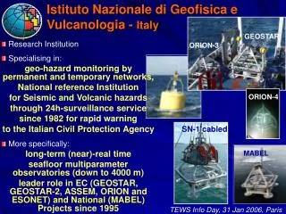
SN-3 GEOSTAR GMM SN-4 SN-1 MABEL (SN-2) A FLEET OF 6 SEAFLOOR OBSERVATORIES SINGLE-FRAME (GEOSTAR-class) Favali et al., Ann.Geophys., 2006
M1 GMM Networking EC Project ASSEM (2002-2004) Corinth Gulf experiment 400 & 42 (GMM) m w.d. (2004; 9 months) ORION NODE-4 (SN-4) Blandin et al., Ocean. Series 69, 2003 Marinaro et al., Environ. Geology, 2004 Rolin et al., Proc. Ocean 2005, 2005 Marinaro et al., Geo-Marine Lett., 2006
Satellite Shore station PC Ship of opportunity Buoy ORION NODE-3 (SN-3) GEOSTAR (main node) Satellite node Satellite node GEOSTAR Networking EC Project ORION-GEOSTAR3 (2002-2005) Marsili volcanic seamount experiment (Southern Tyrrhenian Sea) 3300 m w.d. (2003-2005; 14 months) Favali et al., Ann.Geophys., 2006
GEOSTAR 85 km offshore C.S. Vicentein the Sagres Plateau (Portugal)at 3200 m depth (Aug.07 –on) Seafloor Experiments (1998-2007) 23 deployment & recovery successful operations down to > 3300 m w.d. Weddell Sea (1874 m w.d.) Dec.05-on Adriatic Sea (44 m w.d.) Aug.-Sep.98 Marsili Volcano (3320 m w.d.) Dec.03-Apr.04 Jun.04-May 05 >100 Gbytes (binary data), equivalent to >2000 days of operation Corinth Gulf (400 m w.d.) Apr-Nov 04 Patras Gulf (40 m w.d.) Apr.-Jul.04 Sep.04-Jan.05 Offshore Ustica (2000 m w.d.) Sep.00-Apr.01 GEOSTAR SN-1 ORION Node 3 ORION Node 4 GMM MABEL Offshore Catania (2105 m w.d.) Oct.02-May 03 Real time (cabled) Jan.05-on
NEPTUNE (USA/Canada) North East Pacific Time-series Undersea Networked Experiment http://www.neptune.washington.edu
MARSMonterey Accelerated Research System http://www.venus.uvic.ca NEPTUNE Stage 1 http://www.mbari.org/mars
Cable Connected Ocean Bottom Observatories (Japan) a) JMA Omaezaki System (1978) b) JMA Off-Boso System (1985) c) ERI Off-Ito City System (1994) d) NIED Hiratsuka System (1995) e) ERI Off Sanriku Seismic Network (1995) JAMSTEC: A) Real Time Deep Sea Floor Observatory Off Hatsushima Island in Sagami Bay (1993) B) Long-Term Deep Sea Floor Observatory Off Muroto Peninsula (1997) C) Long-Term Deep Sea Floor Observatory Off Kushiro-Tokachi (1999)
DONET - Dense Ocean floor Network system for Earthquakesand Tsunamis (JAMSTEC, JAPAN) Sensors over 20 Seismometers 20 Pressure gauges www.jamstec.go.jp/jamstec-e/maritec/donet/
Major European Partnership GEOSTAR (1), GEOSTAR 2 (2), MABEL (3), NEMO - SN-1 (4), ASSEM (5), ORION-GEOSTAR 3 (6) , ESONET-CA (7), KM3NET-DS (8), NEAREST (9), ESONET-NoE (10) Italy INGV (1, 2, 3, 4, 5, 6, 7, 8, 9, 10) Tecnomare-ENI (1, 2, 3, 4, 5, 6, 7, 8 , 9, 10) Istituto di Scienze Marine-CNR (1, 2, 6, 7, 8, 9, 10) Istituto Nazionale di Fisica Nucleare (4, 8, 10) Germany Technische Fachhochschule Berlin (1, 2, 3, 4, 6, 7, 9, 10) Technische Universität Berlin (1, 2, 3, 4, 6) IFM-GEOMAR (KDM) (4, 6, 7, 10) France IFREMER (1, 2, 5, 6, 7, 8, 10)
Arctic Norwegian Margin Nordic Sea Porcupine Ligurian Sea Black Sea Marmara Azores Hellenic Eastern Sicily Iberian Margin ESONET GOALS: Geohazards Global change Biodiversity ESONET EC Concerted Action (2002-2004) EC Network of Excellence (2007-2011) 11 Key-sites
NEMO - SN-1: The first real-time cabled seafloor observatory in EUROPE ESONET Eastern Sicily node (since January 2005) INGV Optical sensors Electronic vessels Favali et al., NIMA, 2006; Migneco et al., NIMA, 2006 Established on the basis of an agreement between (MoU, 2001): Istituto Nazionale di Fisica Nucleare (INFN) Istituto Nazionale di Geofisica e Vulcanologia (INGV)
Strategy Towards the multidisciplinary seafloor observation networks The NEW FRONTIER
European Commission September 2006 ESFRI - European Strategy Forum for Research Infrastructures REPORT “European Roadmap for Research Infrastructures” Selection of 35 new large-scale Research Infrastructures http://cordis.europa.eu/esfri/ “Research Infrastructures” refers to tools that provide essential services to the scientific community for basic or applied research European Multidisciplinary Seafloor Observatory EMSO
EMSO-Preparatory Phase Start: 1st April 2008 (4 years) Coordinator: INGV - Paolo Favali (Representing the Italian Funding Agency: University & Research Ministry) • Main objectives: • To establish the governance entity for the EMSO • infrastructure serving scientists and stakeholders in and outside Europe for long-term deep water observations and investigations • To enable the deployment of the infrastructure and its long-term management, including the solution of technical bottlenecks • To promote the catalytic process and synergic effort at EC and national levels, coordinating and harmonising all available resources
General Information Project Costs: € 5.402.220 / EC Funding: € 3.900.000 Kick-off meeting held in Wien on 14st April 2008
Project Objectives Definition and agreement upon the governance and legal form for the Core Legal Entity (CLE) and for each Regional Legal Entities (RLEs) Design of a funding planincluding contributions from national, European, and international funding resources. More specifically, a business plan covering both the investment and the operational expenditures for the first decade of service will be set up Achievement of a long-term commitment from the involved funding agencies will be obtained through the activation of discussion tables where the largest possible political convergence will be reached and formalised in specific agreement protocols and MoUs Definition of operational procedures with regard to deployed instrumentation, logistic intervention and maintenancewill be defined Definition of a long-term strategy and choice of sites Establishment of the engineering specifications for each chosen site
Issues to be solved The diversity of regional sites in terms of available legal frameworks; The harmonisation of funding (National, European, International, industrial) with respect to scope, objectives, and timing; The logistic constraints regarding available resources, and environmental protection; Possible technical bottle necks for which currently no off-the-shelf solution is available
WPs Interconnections WPs are dedicated to 2 major groups of activities Creation of EMSO organisational Body Design of EMSO technical-economic plan
Creation of EMSO organisation body FUNDING AGENCIES AGREEMENT AND COMMITTMENT Technical Economic Plan EMSO-PP will constitute the roundtable to build consensus among Nations
Advisory Board (1/2) It will be composed of external members Scientists, technologists, managers and legal advisors, providing the required expertise and coming also from outside the Europe In charge of: Overseeing the project development and advising continuously on the progress; Providing expert support on specific matters (e.g., legal, financial, engineering); Networking with other infrastructure projects, providing hints on possible integration and sharing of solutions
Membership: ESFRI-European Strategy Forum for Research Infrastructures (EC) KM3NET-PP (EC) JAMSTEC-Japan Agency for Marine-earth Science and TEChnology(Japan) ONC-Ocean Network Canada (Canada) OOI-Ocean Observatory Initiative (USA) EIB-European Investment Bank (Europe) Advisory Board (2/2)
Regional Legal Entities (RLEs) Ultimate output of organisation body set-up Integration of regional infrastructures managing sub-sea observatory sites (RLEs-Regional Legal Entities) all having a single coordination entity (CLE-Core Legal Entity)
Analysis of European structures with similar characteristics Benchmarks with existing organisations at European level (e.g., CERN, ESA, EMBL, etc.) Different solutions of management, decision making procedures and responsibilities will be reviewed with respect to possible application to EMSO
Example 1 (EMBL) www.embl.org
Example 2 (Elettra synchrotron) www.elettra.trieste.it
Financial engineering Member States European Commission Other Stakeholders (e.g., Industry) Funding through RTD programmes or inclusion in DG-REGIO/DG-DEV strategic plans Funding through national programmes Research Infrastructure EIB Loans Up to 50% of project costs
Thankyou foryourattention EMSO coordination team emsopp@ingv.it