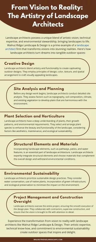
Download
1 / 25
250 likes | 456 Views
From Reality 2010 to Future Vision 2020. Ray A. Williamson, rwilliamson@swfound.org Secure World Foundation. Outline. Vision 2020—My vision for 10 years hence Potential impediments Positive trends Reality 2010—the reality and promise of spaceborne systems and other technologies

E N D
From Reality 2010 to Future Vision 2020 Ray A. Williamson, rwilliamson@swfound.org Secure World Foundation
Outline • Vision 2020—My vision for 10 years hence • Potential impediments • Positive trends • Reality 2010—the reality and promise of spaceborne systems and other technologies • Situational awareness • The wider context • Secure World Foundation
Questions to Answer • Where would we like to be in 10 years? • Where could we be? • Are we making effective use of today’s resources? • Are we integrating new technologies and methodologies into practice sufficiently quickly? • Are the supporting institutions moving with the technologies? • What impediments do we face in reaching the vision?
2020 Space and Air Resources • The use of remote sensing (space and air) is a routine and cost-effective means of support to disaster response and recovery • RS data are routinely and quickly georeferenced and analyzed; resultant information delivered to first responders within 24 hours of collection • Satellite telecommunications are used to deliver information to response and recovery teams throughout the recovery process.
Vision 2020—Situational Awareness • Response and recovery teams, in turn, use the latest in smart phones and other related devices to deliver information back to coordinating organizations. • This closes the information gap between space and aircraft and Earthbound response & recovery teams • Updates the situation on the ground quickly with precise small scale geo-referenced data; results to be compared to any new RS data; provides initial ground-truth • Assists in maintaining safety of life, both for afflicted populations and for response and recovery teams
Vision 2020 Requirements • Vastly improved use of current and immediate future satellite and aircraft resources • Vastly improved geographical and temporal in-situ situational awareness • Vastly improved international organizational and institutional structures • Standard information formats • Organizations work together smoothly and routinely within and across national and institutional borders
The Opportunity Often Falls Short of Reality • Too often the benefits of geospatial data & tools do not reach broadly enough, especially in developing countries • Failures often stem from uncoordinated government policies at different levels of government • Restrictive data policies • More training needed • More scientific, technical education needed • Most important, however, citizens need to become involved in their own future by using tools developed for them and also by them
Other Impediments to Progress • Institutional inertia • No clear pipeline for institutionalizing new methods • National security concerns • Some data sources off limits • Profusion of aid groups • Standards for data/information formats, types, etc? • Standard working methodologies? • Customs, immigration barriers
Positive Trends • Many more countries and groups becoming familiar with RS methods • Google Earth and Bing have made the information potential of RS data and concepts much more accessible to the average computer user than ever before • More countries are developing their own satellite systems • Many more organizations are using RS methods to address disaster response and recovery issues • Volunteer analysts willing to pitch in with analysis
Most RS Satellites Fly in Polar Orbit DMC constellation Credit: SSTL Polar Orbit
Available Space Systems • Many more remote sensing resources than ever before • Many operating satellite systems internationally • Electro-optical • Synthetic aperture radar (SAR) (all weather coverage) • Constellations • Improved position, navigation and timing (PNT) systems • GPS • Galileo • GLONASS • Mobile satellite communications
Other Important Technologies • Airborne remote sensing • Electro-optical cameras; vertical and side view • SAR (all weather coverage) • Lidar (Detailed surface topography) • Powerful analytic software (proprietary & open source) • Image processing • GIS • Automated change detection • PNT capability embedded in many new mobile technologies • Phones, tablets, cameras
Highest Resolution Satellites • GeoEye, U.S. (commercial) • .5-m panchromatic and 1.65-meter multispectral resolution • Digital Globe, U.S. (commercial) • .5-m panchromatic and 1.84-m multispectral resolution • TerraSAR, Germany • Resolution: 1 m, dual-use • Radarsat II, Canada • Resolution: 1 m/ 3 m
Constellations • RapidEye, Germany (private) • Five 6.5 m multispectral EO satellites in constellation • Daily imagery across the globe • Cosmo-SkyMed, Italy • Four SAR satellites at maximum 1m resolution • Digital Globe (quasi-constellation) • Three satellites (all different resolutions & other characteristics)
Situational Awareness • Response and recovery crews need better situational awareness • Understand where is the greatest need for assistence • Have a clear idea of the dangers they might face, from damaged structures , the environment, and from the local population • Need to be able to communicate that information back to assisting agencies
Community Remote Sensing Is… • “a new field that combines remote sensing with citizen science, social networks, and crowd-sourcing to enhance the data obtained from traditional sources. • It includes the collection, calibration, analysis, communication, or application of remotely sensed information by these community means.” • IGARSS brochure for the 2010 IGARSS conference in Hawaii
Community Remote Sensing • Satellite remote sensing services tend to be delivered top-down—with experts developing services to meet a perceived need: • CRS works in the other direction—individuals contributing data and adding valuable information to satellite or aerial data • CRS enhances the value of RS data to benefit the community • CRS works by involving the community, whether geographical or disciplinary, in the enhancement of information to benefit the community as a whole
Making CRS Work: Smart Phone Application http://www.youtube.com/watch?v=z4UAO_i1S7Y Courtesy of International Space University students Space Studies Session 2009
The Wider Context • Disaster response and recovery fits into a much wider picture than presented here • To achieve the vision presented here will require operational improvements in many areas of human endeavor: natural resource management and protection; pollution reduction and control, etc. • My wider vision is a world where individuals and community groups have routine access to satellite and aerial data and use CRS methods to improve their own quality of life
Advertisement Imaging Notes Magazine http://www.imagingnotes.com
Secure World Foundation Secure World Foundation (SWF) is a private operating foundation dedicated to the secure and sustainable use of space for the benefit of Earth and all its peoples.
What does the Foundation do? • Engages with academics, policy makers, scientists and advocates in the space and international affairs communities to support steps that strengthen global space sustainability. • Promotes the development of cooperative and effective uses of space for the protection of Earth’s environment and human security. • Acts as a research body, convener and facilitator to advocate for key space security and other space related topics and to examine their influence on governance and international development.
Key Governance Focus Areas • Space sustainability • Protection of continued utility of space resources • Policy development in Emerging Space States • Human & environmental security • Development and disaster assistance • Environmental change • Planetary threats • Mitigating the threat of collision from a Near-Earth Object (NEO) through the establishment of effective international governance for response