Download
1 / 17
170 likes | 263 Views
Integration with a Web Application to Create Navigational Instructions for Locations on the Campus of Elizabeth City State University. Members. Je'Aime Powell Mentor. Nyema Barmore Undergrad Student . Michael Austin Undergrad Student . Andrew Brumfield Undergrad Student . Justin Deloatch

E N D
Integration with a Web Application to Create Navigational Instructions for Locations on the Campus of Elizabeth City State University
Members Je'Aime Powell Mentor Nyema Barmore Undergrad Student Michael Austin Undergrad Student Andrew Brumfield Undergrad Student Justin Deloatch Grad Student
Overview • Purpose • Abstract • Research Questions • Methodology • Problem/Solutions • Conclusion • Future Works
Abstract Mashups are an exciting genre of interactive Web applications that draw upon content retrieved from external data sources to create entirely new and innovative services. The purpose of the Mobile Applications Research Team was to create an interface mashup in which geographic information and meta data from buildings located on the campus of Elizabeth City State University (ECSU) can be presented to users via mobile platforms. The project includes HTML5 programming which referenced a database that housed information such as location, building establishment date, academic departments, andacademic programs. The information was then compiled using a PHP Hypertext Processor (PHP) form to populate a MySQL database. HTML5 coupled with PHP programming was then used to render a mobile web page with both map and database information. Using Google Map Makerpaths, streets, and buildings were created in appropriate geographic locations on the ECSU campus. The Google Maps Application Programming Interface was then used to generate Uniform Resource Locator's to both retrieve user Global Positioning System coordinates and create walking directions to selected locations. The user then had the ability to generate walking directions to locations on the university's campus.
Research Questions • How to add buildings, sidewalks, and streets to Google Maps? • How to generate walking directions? • How to extract Geo-location information from mobile devices?
Methodology Google Maps • No Buildings • Incorrect Streets • No walking paths
Methodology • Added Buildings • Added Street • Added Paths Google Map Maker
Methodology http://maps.google.com/maps?saddr=position.coords.latitude,position.coords.longitude&daddr=buildinglat,buildinglong&hl=en&&geocode=FbmlKQIdVQ91-w%3BFTykKQId8Bp1-w&dirflg=w&mra=ls&t=m&z=17 Google API
Methodology http://maps.google.com/maps?saddr=position.coords.latitude,position.coords.longitude&daddr=buildinglat,buildinglong&hl=en&&geocode=FbmlKQIdVQ91-w%3BFTykKQId8Bp1-w&dirflg=w&mra=ls&t=m&z=17 Google API HTML 5 Source Code function initiate_geolocation() { navigator.geolocation.getCurrentPosition(handle_geolocation_query,handle_errors);
Methodology http://maps.google.com/maps?saddr=position.coords.latitude,position.coords.longitude&daddr=buildinglat,buildinglong&hl=en&&geocode=FbmlKQIdVQ91-w%3BFTykKQId8Bp1-w&dirflg=w&mra=ls&t=m&z=17 Google API PHP Source Code <?php echo $row_DetailRS1['LATITUDE']; ?>,<?php echo $row_DetailRS1['LONGITUDE']; ?>
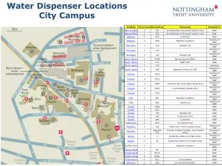
Problems/Solutions Marked locations Walking directions error
Problems/Solutions Marked locations Walking directions after re-indexing (April 4th, 2012)
Conclusions • How buildings, sidewalks and streets were added toGoogle Maps. • Howwalking directions were generated. • How geolocation information was extracted frommobile devices.
Future Works • Emergency Response Boxes (Blue Boxes) • ECSU Shuttle Bus • School Events • Check In Feature
Demo http://nia.ecsu.edu/mobile/eb.html