Download
1 / 9
90 likes | 93 Views
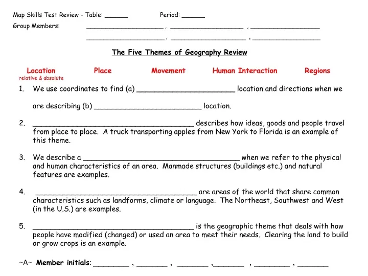
Map Skills Test Review - Table: ______ Period: ______ Group Members: ____________________ , ___________________ , __________________ _______________________ , ______________________ , ____________________.

E N D
Map Skills Test Review - Table: ______ Period: ______ Group Members: ____________________ , ___________________ , __________________ _______________________ , ______________________ , ____________________ • We use coordinates to find (a) ______________________ location and directions when we are describing (b) ________________________ location. • ____________________________________ describes how ideas, goods and people travel from place to place. A truck transporting apples from New York to Florida is an example of this theme. • We describe a ___________________________________ when we refer to the physical and human characteristics of an area. Manmade structures (buildings etc.) and natural features are examples. • 4. ____________________________________ are areas of the world that share common characteristics such as landforms, climate or language. The Northeast, Southwest and West (in the U.S.) are examples. • ____________________________________ is the geographic theme that deals with how people have modified (changed) or used an area to meet their needs. Clearing the land to build or grow crops is an example. • ~A~ Member initials: _______ , ______ , ______ ,______ , _______ , ______
Provide three examples for each: • Human-Environmental Interaction: • a. ______________________________________________________________ • b. ______________________________________________________________ • c. ______________________________________________________________ • Movement of goods: • a. ______________________________________________________________ • b. ______________________________________________________________ • c. ______________________________________________________________ • Movement of ideas: • a. ______________________________________________________________ • b. ______________________________________________________________ • c. ______________________________________________________________ • ~B~ Member initials: _______ , ______ , ______ ,______ , _______ , ______
A.aerial photographD.longitudeG.latitude • B.globeE.meridianH.parallel • C.mapF.Prime MeridianI.absolute location • J.Equator • _____ flat drawings of Earth that usually only show part of the surface (of Earth) • 2. _____ is where latitude lines and longitude lines (coordinates) cross to pinpoint the exact location of places on earth (ex. 47°N ; 128°W) • _____ round model that shows Earth’s entire surface • _____ vertical lines that run north and south and are used to measure degrees east and west of the Prime Meridian • _____ photographs produced by satellites that enable you to see patterns on Earth’s surface and identify patterns shown on maps • _____ another name for longitude • _____ longitude line that has zero degrees and splits the Earth into the Eastern Hemisphere and Western Hemisphere (starting point for measuring longitude) • _____ horizontal lines that run east and west and are used to measure degrees north and south of the Equator • _____ another name for latitude • _____ latitude line that has zero degrees and splits the Earth into the Northern Hemisphere and Southern Hemisphere (starting point for measuring latitude) • ~C~ H11-H12 Member initials: _______ , ______ , ______ ,______ , _______ , ______
cardinal directions D. scale F. locator • intermediate directions E. map symbol G. map key (legend) • relative location • 1. _____ used to represent actual things in a place; anything on a map that stands for something else • 2. _____ shows the relationship between distances on a map and actual distances on Earth • 3. _____ tells you what each symbol stands for on a map • 4. _____ the main directions (north, south, east & west) • 5. _____ tells us where in the world the subject of the main map is located • 6. _____ describes one place in relation to another (what direction it is from the place or what it’s close to or near etc.) • 7. _____ the in-between directions or points between the cardinal directions • (NW = northwest, NE = northeast, SW = southwest & SE = southeast) • H13-H15 – Q2 • ~D~ Member initials: _______ , ______ , ______ ,______ , _______ , ______
A. political map C. physical map E. elevation map B. historical map D. distribution map F. relief ______ shows how people, languages, religion, rainfall, or other information (like resources) are spread out through an area ______ (type of physical map) use color to show the height of land above sea level ______ shows capital cities, states, countries and other political information ______ shows Earth’s natural features such as landforms ______ shows information about the past or where past events took place ______ shading to show mountains, hilly areas and changes in elevation (used on some physical maps) H16-H18 ~E~ Member initials: _______ , ______ , ______ ,______ , _______ , ______
Continents: • _____________________________________________ • _____________________________________________ • _____________________________________________ • _____________________________________________ • _____________________________________________ • _____________________________________________ • _____________________________________________ • Oceans: • _____________________ 3. ____________________ 5. ___________________ • _____________________ 4. ____________________ • Hemispheres: • _____________________________ 3. ___________________________ • _____________________________ 4. ___________________________ • ~F~ Member initials: _______ , ______ , ______ ,______ , _______ , ______
Use the Atlas of the World for Intermediate Students: • What is the difference between the maps on page 22 and 23? • ___________________________________________________________________________________________________ • (a) What is the highest point in South America? (b) What is the lowest point? • (a) ________________________________________________ (b) ________________________________________ • Which side (direction) of South America has the highest elevation on average? How do you know? • ________________________________________________ • La Paz, Boliva is _____________________ (direction) about _____________ miles of Lima, Peru. • Montevideo, Uruguay has an absolute location of (___________________) • According to the map on p. 24, the _____________________ part of South America is most populated. • What types of maps are on p. 24 & 25? Explain. __________________________________ • _______________________________________________________________________________________________________ • Why might the northern part of Chile and the northwestern part of Argentina have little or no economic activity (use all maps p. 22-25 to help you). _______________________________ • __________________________________________________________________________ • ~G~ Member initials: _______ , ______ , ______ ,______ , _______ , ______
Use the Atlas of the World for Intermediate Students: • What is the difference between the maps on page 22 and 23? • p. 22 physical p. 23 political • (a) What is the highest point in South America? (b) What is the lowest point? • (a) Cerro Aconcagua (b) Valdes Peninsula • Which side (direction) of South America has the highest elevation on average? How do you know?West • La Paz, Bolivia is southeast or SE (direction) about 600 miles of Lima, Peru. • Montevideo, Uruguay has an absolute location of (35° S; 55 ° W) • According to the map on p. 24, the southeastern part of South America is most populated. • What types of maps are on p. 24 & 25? Explain. Distribution Maps . . . They illustrate (show) how South America’s population and resources are spread throughout the country. • Why might the northern part of Chile and the northwestern part of Argentina have little or no economic activity (use all maps p. 22-25 to help you). Mountainous
Continents: • North America 5. Asia • South America 6. Australia • Europe 7. Antarctica • Africa • Oceans: • Atlantic 3. Indian • Pacific 4. Arctic • Hemispheres: • Northern 3. Eastern • Southern 4. Western