Download
1 / 33
390 likes | 857 Views
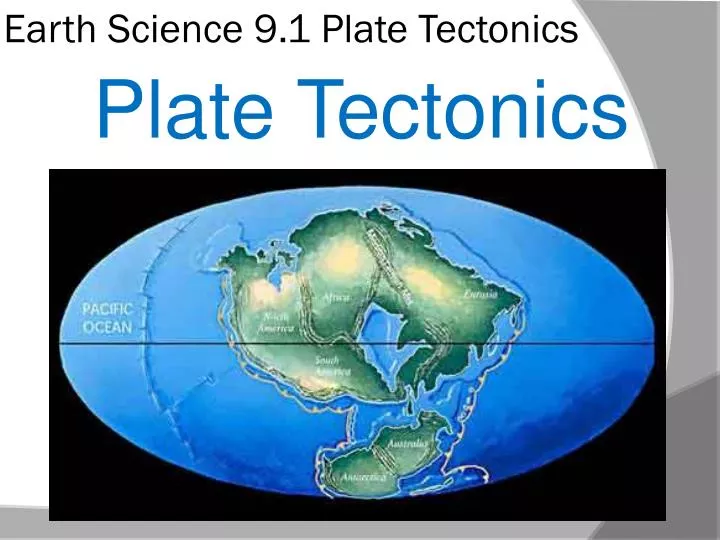
Earth Science 9.1 Plate Tectonics . Plate Tectonics . Continental Drift: Pangea . In 1915, German scientist Alfred Wegener noticed similarities between the coastlines of Africa and South America on opposite sides of the Atlantic Ocean.

E N D
Earth Science 9.1 Plate Tectonics Plate Tectonics
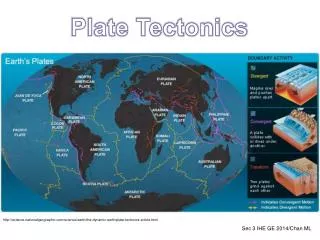
Continental Drift: Pangea • In 1915, German scientist Alfred Wegener noticed similarities between the coastlines of Africa and South America on opposite sides of the Atlantic Ocean. • Wegner proposed his theory of continental drift; that the continents had once been joined to form a single landmass; a super-continent we called Pangea.
Continental Drift: Pangea • Wegener also hypothesized that about 200 million years ago, Pangaea began breaking into smaller continents. • The continents then slowly drifted to their present positions.
Continental Drift: Pangea • Wegener presented a variety of evidence to support his theory of continental drift. • His evidence included • Similar fossils from different locations • Matching types of rocks • Traces of glaciations on widely separated landmasses
Continental Drift: Pangaea • Matching Fossils: • Fossil evidence for continental drift comes from several identical types of fossil remains found on different landmasses. • Remains of identical plants and animals in fossilized form prove that these landmasses were once connected at a point in history.
Continental Drift: Pangaea • Matching Types of Rocks: • Besides fossils, matching types of rocks in several mountain belts in different parts of the globe indicate that these areas were once connected. • In the chart at right, we see fluorite deposits that match each other in several parts of the world that are now widely separated.
Continental Drift: Pangaea • Matching Types of Rocks: Mountain Ranges • As well, we find larger evidence in the forms of mountain ranges. The Appalachian mountain range that ends in Newfoundland has mountains of the same size and rock types as mountains found in northern Europe.
Continental Drift: Pangaea • Ancient Climates: • Wegener also found evidence for dramatic global climate changes that supported his hypothesis. • Wegener found glacial deposits showing that, between 220 million and 300 million years ago, ice sheets covered large areas of the southern hemispheres. • Deposits of glacial till occurred at latitudes that today have temperate-hot climates (southern Africa, South America, India, and Australia)
Continental Drift: Pangaea • Ancient Climates: • Below these beds of glacial debris lay scratched and grooved bedrock that revealed the passing of glaciers in the past. • In some spots, the grooves showed that glaciers had moved from what is now sea onto land. It is unusual for glaciers to move from sea to land. • It is also unusual that many of the places that showed evidence of these glaciers now lies near the equator in subtropical zones.
Continental Drift: Pangaea • Ancient Climates: • Could Earth have been cold enough to allow the formation of glaciers in what is now tropical regions? • Wegener thought a better explanation was that these lands had been in a different location in relation to the planet at an earlier point in time. • Wegener proposed that a supercontinent had once existed with all the land masses being part of it.
Continental Drift: Pangaea • Ancient Climates: • Over time, these landmasses drew apart. • Theglacial evidence indicates that at an early point; the south tip of Africa, southeast side of South America, and southern tips of India and Australia were all joined together and covered by an enormous ice sheet.
Continental Drift: Pangaea • Wegener’s Hypothesis meets Rejection: • At first, Wagener’s hypothesis received much criticism from scientists. • The main objection was that no one could describe a mechanism by which the continents could move.
Continental Drift: Pangaea • Wegener’s Hypothesis meets Rejection: • Wegener proposed many ways that the continents could move; from the moon’s influence on the Earth to larger continents breaking through the oceanic crusts. • By 1967, a new theory developed that linked with Wegener’s way of thinking. The theory of plate tectonics provided explanation for the continental drifting as well as many other geological processes.
Computer lab: • Use the internet to research and write on the following topic: Write three paragraphs answering the following three questions: DO NOT COPY CUT OR PASTE • What is the hypothesis of continental drift? • List the evidence that supported the hypothesis of continental drift. • Why did scientists at first reject Wegener’s drift hypothesis?
Earth Science 9.2 Sea Floor Spreading Sea Floor Spreading
Sea Floor Spreading • Data from the middle of the Atlantic ocean indicated that a large undersea mountain range existed where we thought should have been deep ocean waters. • During the 1900s, a new technology appeared called Sonar (sound navigation and ranging) ; a system that uses sound waves to calculate the distance to an object. • With sonar, a ship can send out pulses toward the bottom. The returning sonar waves reveal how far away the bottom is. • The deeper the water, the longer it takes the sound to return.
Sea Floor Spreading • Deep Ocean trenches: • As scientists mapped the ocean floor, they found long, curved valleys along the edges of some ocean basins called deep ocean trenches. • Trenches form the deepest parts of Earth’s oceans. Most trenches occur around the edges of the Pacific ocean although trenches occur in the Indian and Atlantic ocean as well.
Sea Floor Spreading • Mid Ocean Ridges: • By the late 1950s, scientists had constructed a more complete map of the earth’s ocean floor. • This map showed a mid-Atlantic ridge; a long mountain chain that ran the length of the Atlantic ocean. • Earth’s mid-ocean ridge system forms the longest feature on Earth’s surface. The system winds for more than 70,000 kilometers through all the major ocean basins like the seam on a baseball.
Sea Floor Spreading • Composition of Ocean Floor: • Earth’s ocean floors are made of igneous rocks. Scientists found that this layer of basaltic sediment became thinner closer to the mid-ocean ridges. Along the ridges themselves, there was no sediment at all. • The new maps of the ocean floors aroused curiosity of many scientists. • One geologist, Harry Hess, thought the mid-ocean ridges might help explain how the ocean floor was formed. In 1963, Hess published his hypothesis of sea- floor spreading.
Sea Floor Spreading • Process of Sea-Floor Spreading: • In the process of sea-floor spreading, new ocean floor forms along Earth’s mid-ocean ridges, slowly moves outward across ocean basins, and finally sinks back into the mantle beneath deep-ocean trenches. • During sea-floor spreading, new oceanic lithosphere is formed, and the ocean floor gets wider. • Today, the Atlantic ocean is thousands of kilometers wide. Millions of years ago, the Atlantic would have been a much narrower sea.
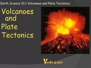
Sea Floor Spreading • Eruptions along the Mid-Ocean Ridges: • How did the mid-ocean ridges form? Scientists found evidence that the mid-ocean ridges formed as the result of volcanic activities. • Fractures along the central valley of a mid-ocean ridge fill with magma that wells up from within the hot mantle below.
Sea Floor Spreading • Gradually, the magma cools to produce new areas of ocean floor. This spreading and upwelling of magma continuously adds new ocean floor. • The process can also begin on land when a rift valley forms and splits a continental landmass.
Sea Floor Spreading • Movement of the ocean floor: • As new ocean floor is added along mid-ocean ridges, the older ocean floor moves outward and away from the ridge on both sides. • Rates on sea-floor spreading average about 5 centimeters per year; slow on human time scale but fast enough that all of Earth’s oceans could have been formed within the last 200 million years.
Sea Floor Spreading • Subduction at Deep-Ocean Trenches: • Although new ocean floor is constantly being added at the mid-ocean ridges, our planet is not growing larger. Earth’s total surface remains the same. • To accommodate newly created lithosphere, older portions of the ocean floor return to the mantle in a process we call subduction.
Sea Floor Spreading • Evidence of Sea-Floor Spreading: • Hess’s hypothesis attracted the attention of geologists. What evidence was there to prove Hess’s hypothesis? • Evidence for sea-floor spreading includes • Magnetic strips in ocean-floor rock • Earthquake patterns • Measurements of the ages of ocean floor rocks
Sea Floor Spreading • Magnetic Strips: • The magnetic properties of the rock that makes up the ocean floor provided evidence for sea-floor spreading. • To understand this evidence, you need to understand how some rocks can become magnetized. • Geophysicists learned that Earth’s magnetic field occasionally reverses polarity. • The North magnetic pole becomes the South magnetic pole, and vice versa.
Sea Floor Spreading • Magnetic Strips: • Scientists graphed these reversals over millions of years. • When earth’s magnetic field lines up in the same direction as the present magnetic field, it is said to have normal polarity. • When the magnetic field lines up in the opposite direction, it is said to have reverse polarity.
Sea Floor Spreading • Magnetic Strips: • As certain rocks form, they acquire the polarity of the Earth’s magnetic field at the time they formed. • These rocks possess paleomagnetism. • Once the rock is formed, it’s polarity remains frozen unless the rock is heated above a certain level. • When the earth’s polarity shifts, the rock’s paleomagnetism does not change.
Sea Floor Spreading • Magnetic Strips: • Scientists study the magnetic polarity of areas of the sea floor by towing instruments called magnetometers across the ocean floor. • The data they collected revealed a series of alternating strips of magnetic rock on the ocean floor. • Strips of rock with normal polarity alternated with strips with reversed polarity. • Scientists inferred from this that as new basalt formed along ocean ridges, it becomes magnetized according to the polarity of the earth at that moment. • These matching patterns of alternating magnetic strips provide evidence of sea-floor spreading.
Sea Floor Spreading • Earthquake patterns: • More evidence for sea-floor spreading came from studies of the depth at which certain earthquakes occur. • Scientists knew that there were many earthquakes in subduction zones. • Scientists discovered that shallow-focus earthquakes tend to occur in and around a trench. • Intermediate focus anddeep focusearthquakes occur in a belt about 50 kilometers thick. • This belt extends through the lithosphere and deep into the asthenosphere.
Sea Floor Spreading • Earthquake patterns: • As we see in the chart at right, the deeper the earthquake foci, the farther away it is from the ocean trench. • (greenindicates shallow foci; yellowmedium depth foci, redindicates deep foci) • Scientists considered the pattern of earthquakes in relation to sea-floor spreading. This data convinced scientists that slabs of ocean floor return to the mantle in subduction zones.
Sea Floor Spreading • The Age of the Ocean Floor: • Drilling into sediment on the ocean floor and the crust beneath it provides some of the best evidence of sea-floor spreading. • Data from drilling confirmed that the sea-floor spreading hypothesis was correct. • The ocean floor is youngest along the central valley of the mid-ocean ridge. The ocean floor is oldest in Subduction zones or near the edges of continents far from the ridge. • The data also confirmed that none of the ocean floor is older than 180 million years old
Computer lab: • Computer lab: Use the internet to research and answer the final 4 questions: DO NOT COPY, CUT OR PASTE • Describe the mid-ocean and deep-ocean trenches. • Explain what occurs during sea-floor spreading. • List the evidence for sea-floor spreading. • What is the Wadati-Benioff zone?