Download
1 / 30
400 likes | 1.2k Views
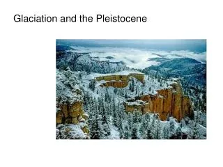
Pleistocene Glaciation of North America. Pleistocene Ice Ages. Direct Effects of Past Glaciation. Most of the soil and sedimentary rocks were scraped off of underlying crystalline rock in northern and eastern Canada Future lake basins were gouged out of the bedrock

E N D
Direct Effects of Past Glaciation • Most of the soil and sedimentary rocks were scraped off of underlying crystalline rock in northern and eastern Canada • Future lake basins were gouged out of the bedrock • Extensive sets of recessional moraines were left behind by retreating ice sheets in the upper midwestern U.S. and in Canada
Indirect Effects of Past Glaciation • Large pluvial lakes (formed in a period of abundant rainfall) existed in closed basins in Utah, Nevada and eastern California • Great Salt Lake is a remnant of the much larger pluvial Lake Bonneville • Huge floods emanated as ice-dammed lakes (e.g., Lake Missoula) drained catastrophically • Sea level was significantly lowered by large amounts of water locked up into ice sheets, allowing stream channels and glaciers to erode valleys below present-day sea level Giant gravel ripples formed during draining of Lake Missoula
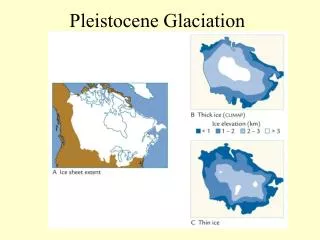
Ice Ages in North America Continental Glaciers advanced & Receded at least 4 times during past 2 million years During glacial advances, sea level drops exposing continental shelf Maximum advance of last glacier 18,000 yrs ago Sea level rises 300 ft by 8,000 yrs, resulting in present coastline
Fjiords Coastal inlets formed by drowning of glacially carved valleys by rising sea level
Retreat of the Wisconsinan Glacier • Maximum extent of ice about 21,750 years ago • 14,000 years ago – retreating glacier • 12,000 – 13,000 years ago
Retreat of the Wisconsinan Glacier • Stages D, E, and F occurred 11,000 to 12,000 years ago • The final stage was approximately 11,000 years ago
Continental Glaciers Retreat forming Long Island of Today • Lakes form as ice sheet melts • Sea Level Rises • LI Sound fills with water from Ocean • LI takes modern form • (from Newsday “Long Island Our Story”
Topography of Long Island North Shore: Irregular Coast & Hilly South Shore: Straight Coast & Flat Digital Elevation Model: 2X Vertical Exaggeration (Bennington, 2003) Data from NYSDEC & Cornell University
Glacial Features of LI Lake Ronkonkoma Harbor Hill Moraine Ronkonkoma Moraine Outwash Plain Kames
Glacial Till Unsorted Sediments were deposited directly by ice. Round shape of many boulders indicates that they were also shaped by running water Eroding moraine at Montauk Boulders at Orient
Glacial Features of Smithtown & Central LI Harbor Hill Moraine Ronkonkoma Moraine Lake Ronkonkoma Outwash Plain
Harbor Hill Moraine Closeup view of Till of Harbor Hill Moraine consisting of unsorted silt, sand, pebbles, and cobbles Till of Harbor Hill Moraine overlying outwash deposits (RTE 25 A, Setauket)
Kame Deltas indicate large pro-glacial lakes as continental glacier melted Harbor Hill Moraine Kame Deltas Ronkonkoma Moraine Outwash Plain Note: Kame Deltas overlie Ronkonkoma Moraine What does this indicate about the relative age of the Deltas?
Glacial Features of Huntington Area Delta Deposits Harbor Hills Moraine Outwash Channels Outwash Plain
Delta Deposits at Caumsett • The sediments in the cliffs formed when streams of water carrying sand and gravel gushed from the glacier and entered the lake. The faster the water the larger size sand grains, pebbles or boulders it can carry. Upon reaching the still water, the streams slowed and dropped their sediments forming a delta.
Weathering breaks rocks down & Erosion wears away land & transports sediments Frost Action split this rock Erosion of bluffs at Caumsett, forming fan
Rivers Erode the Land Smithtown Harbor Carman’s River Nissequogue River Ronkonkoma Moraine
Carman’s River Carman’s River cuts through the Ronkonkoma Moraine.