Download
1 / 8
80 likes | 178 Views
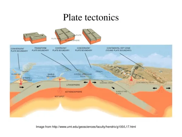
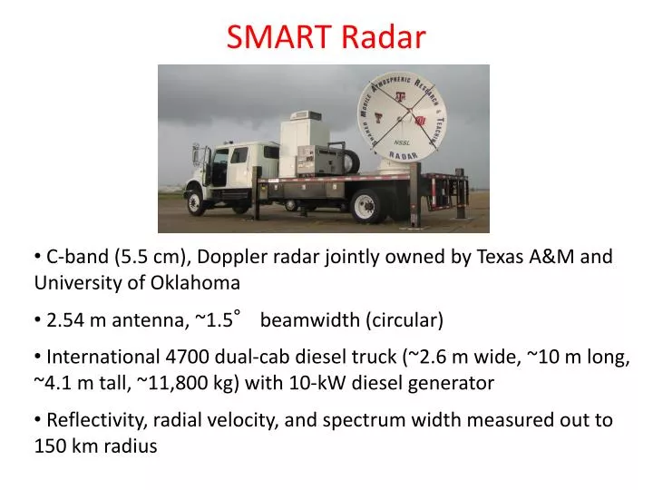
SMART Radar. C-band (5.5 cm), Doppler radar jointly owned by Texas A&M and University of Oklahoma 2.54 m antenna, ~1.5° beamwidth (circular) International 4700 dual-cab diesel truck (~2.6 m wide, ~10 m long, ~4.1 m tall, ~11,800 kg) with 10-kW diesel generator

E N D
SMART Radar • C-band (5.5 cm), Doppler radar jointly owned by Texas A&M and University of Oklahoma • 2.54 m antenna, ~1.5° beamwidth (circular) • International 4700 dual-cab diesel truck (~2.6 m wide, ~10 m long, ~4.1 m tall, ~11,800 kg) with 10-kW diesel generator • Reflectivity, radial velocity, and spectrum width measured out to 150 km radius
Potential SMART-R Maldives Deployment • SR1 is available for entire CINDY2011/DYNAMO time frame • Will provide 3-D observations of convection and area rainfall useful for budget studies • SR1 can be shipped with its truck (more difficult to ship, but more flexibility on-site) or can possibly be containerized without the truck (easier to ship, less flexibility on-site) • SR1 has been run for extended periods in Texas and Costa Rica, but needs operators (which can be trained on-site) • Experience from MISMO X-band deployment on Gan Island will be useful
MISMO Observation Network: Oct.24 – Nov.25 Hulhule Is. Radiosonde AWS、GPS Float Temp / Salinity Mooring Buoys Surface Met. Temp, Salinity, Current, etc. Kadhdhoo Is. AWS、GPS R/V Mirai Doppler Radar Radiosonde Wind Profiler CTD etc. Gan Is. Doppler Radar Radiosonde AWS、GPS、 Ceilometer, etc.
Gan Island (0.7S, 73.2E) Gan Met Office AWS、GPS、Ceilometer, Disdrometer, Microwave Radiometer, Radiosonde Gan Is. Doppler Radar Site Doppler Radar, Sodar, Sky View Camera 2.5km
360 View (from the top of the tower) 9月9日(レーダー設置時) 10月21日(観測開始直前) 南 北 西
Stepwise Mostening <-> Eastward-Propagating Cloud MSE IR-TB Stepwise growth of the moist layer Eastward-Propagating Cloud Signal (EPCS) (spd: 8m/s e’ward)
EVAD (CYLBIN) @ Gan Is. topic-1 topic-2 topic-3