Download
1 / 19
190 likes | 691 Views
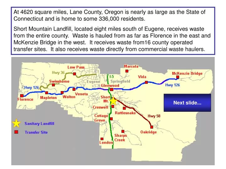
At 4620 square miles, Lane County, Oregon is nearly as large as the State of Connecticut and is home to some 336,000 residents.

E N D
At 4620 square miles, Lane County, Oregon is nearly as large as the State of Connecticut and is home to some 336,000 residents. Short Mountain Landfill, located eight miles south of Eugene, receives waste from the entire county. Waste is hauled from as far as Florence in the east and McKenzie Bridge in the west. It receives waste from16 county operated transfer sites. It also receives waste directly from commercial waste haulers. Next slide...
Short Mountain Landfill is located on a 540 acre site next to Interstate-5. The facility receives about 800 tons of garbage per day. Next slide...
This June 2006 aerial photo shows the footprint of the landfill. The current area of the landfill footprint is 86 acres. Next slide...
Although the name Short Mountain refers to the hill located to the north of the site, the landfill itself rises approximately 160 feet above the valley floor – truly a mountain of trash. Next slide...
The first three disposal cells highlighted in orange represent development of the landfill from its opening in 1976 through 2004. The 14 acre “Phase IV” disposal cell (yellow) opened in August 2004, and is expected to provide disposal capacity for Lane County through 2007. Next slide...
SML SITE DEVELOPMENT PLAN Phase X Phase IX Phase XI Phase VIII Phase VII Phase VI Phase V Phase IV Phase I/II Phase III Long-range plans predict closure of the final cell - Phase XI – around the year 2088. Next slide...
CELL DEVELOPMENT Next slide...
CELL DEVELOPMENT Next slide...
CELL DEVELOPMENT Next slide...
CELL DEVELOPMENT Next slide...
As portions of the landfill reach final elevations, they are “closed” by covering the surface with a thick plastic liner which is then covered with soil and planted with grass. A Next slide...
CELL CLOSURE B Next slide...
CELL CLOSURE C Next slide...
Active disposal cells are built to stringent specifications regulated by the Department of Environmental Quality. A complex bottom liner system is designed to prevent leachate (water that percolates through the landfill) from contaminating groundwater, and a collection system routes leachate to a storage lagoon. A separate network of pipes collects methane produced in the landfill for use in generating electricity. Methane is piped to an electricity generation plant Next slide... Leachate is piped to a lined storage lagoon
The methane-to-electricity plant has four turbine engines that generate enough electricity to power about 1200 homes. The plant is operated by Emerald People’s Utility District (EPUD). Next slide...
In this view, the current leachate storage lagoon is highlighted in green. The covered lagoon can safely store up to 2.3 million gallons of leachate. During rainy Western Oregon winters, that’s a little more than two month’s worth of leachate production. Next slide... The decommissioned former leachate lagoon highlighted in blue now holds fresh water.
This photo, taken from the top of the landfill, shows the covered leachate storage lagoon (white) next to the fresh water lagoon. Beyond the leachate storage lagoon you can see part of the wetland mitigation area for the landfill located to the south of the Camas Swale Creek. Between the creek and the landfill there are several groundwater monitoring wells. • add slide from top view for leachate lagoon and QP Next slide...
Short Mt. Landfill offers the only approved disposal site in Lane County for friable asbestos. The asbestos disposal area (in red) is also used for disposal of sharps (hypodermic needles and similar medical wastes). Next slide...
In addition to its landfill functions, the site is used by public safety agencies for firearms and other training (yellow) Next slide...