Download
1 / 10
100 likes | 207 Views
Hurricane Sandy Threat Timeline. Bryan Norcross Sr. Executive Director of Weather Content Sr. Hurricane Specialist The Weather Channel Interdepartmental Hurricane Conference College Park, MD March 5, 2013. Characterizing the Threat. Threat is POSSIBLE

E N D
Hurricane Sandy Threat Timeline Bryan Norcross Sr. Executive Director of Weather Content Sr. Hurricane Specialist The Weather Channel Interdepartmental Hurricane Conference College Park, MD March 5, 2013
Characterizing the Threat Threat is POSSIBLE Threat is an INCREASING POSSIBILITY Threat is LIKELY IF NO CHANGES Threat is LIKELY Threat is IMMINENT Each level of THREAT has a MESSAGE.
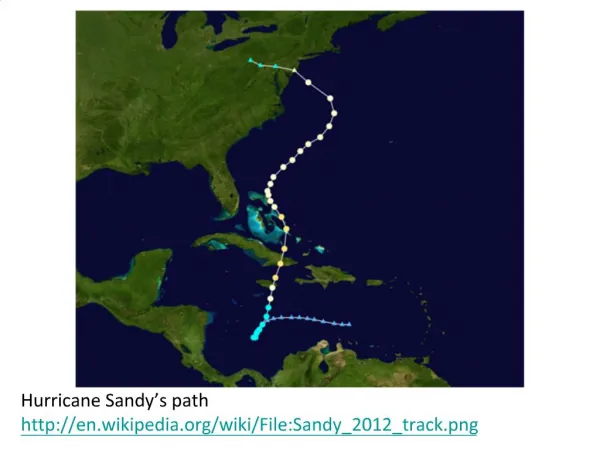
Sunday – October 21 European & Canadian models show a storm near the Northeast early the following week Threat: POSSIBLE strong storm early week Message: Cautionary, if any
European Center computer model and other forecasts continue to show a significant storm near the Northeast early the following week Monday – Wednesday Threat: POSSIBLE dangerous storm Monday Message: Cautionary, if any
National Hurricane Center forecasts storm track into New Jersey WORST CASE track for storm surge in the NYC region 11 AM Thursday Threat: INCREASING POSSIBILITY of storm Message: Forecast shows a storm worse than Irene Monday. Evacuations possible.
National Hurricane Center forecasts storm track into New Jersey WORST CASE track for storm surge in the NYC region 5 PM Thursday
National Hurricane Center forecasts storm track into New Jersey WORST CASE track for storm surge in the NYC region. Water on right side of storm pushed into New York bight. 5 PM Thursday Threat: INCREASING POSSIBILITY of storm Message: Forecast continues for storm worse than Irene. Evacuations more likely.
National Hurricane Center: USERS ARE REMINDED TO NOT FOCUS ON THE DETAILS OF THE TRACK FORECAST...AS SANDY IS EXPECTED TO BRING IMPACTS TO A LARGE PART OF THE U.S. EAST COAST INTO EARLY NEXT WEEK. Friday Threat: LIKELY IMPACT if no forecast change Message: Forecast continues for storm surge worse than Irene. Evacuation orders likely Saturday. Begin preparation of property.
National Hurricane Center 11 AM Forecast: Storm Surge 4 – 8 FEET above ground Irene surge: 4.36 FEET Saturday Threat: Inundation of coastal sections LIKELY Message: Storm surge worse than Irene LIKELY. Perhaps much worse. Evacuation ordered for Sunday morning.
Key Questions What is the WORST PLAUSIBLE THREAT based on what we know now? When will we know more? What is the EVACUATION COMMUNICATIONS TIMELINE to allow for mental and physical preparations by residents and visitors?