Download
1 / 88
910 likes | 1.11k Views
Political Geography. Chapter 8. Introduction. Political geography helps explain the cultural and physical factors that underlie political unrest

E N D
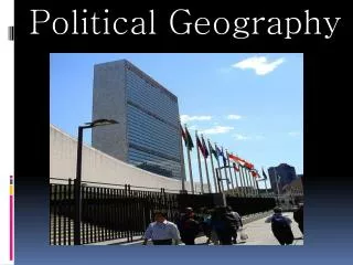
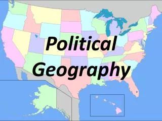
Political Geography Chapter 8
Introduction • Political geography helps explain the cultural and physical factors that underlie political unrest • Political geographers study how people have organized Earth’s land surface into countries and alliances, the reasons for doing so, and the conflicts that can erupt from the organization
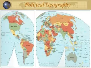
Where are States Located? • Almost all land on the Earth belongs to a country • Not true as recently as 1940s – only about 50 countries then • Now there are 192 members of the UN • State- an area organized into a political unit and ruled by an established gov. that has control over its internal and foreign affairs • Occupies a defined territory and has a permanent population
continued • Sovereignty- independence from control of its internal affairs by other states • States are examples of formal regions because the entire territory is ruled by a common gov., laws, military etc. • Country and state are synonyms
Problems of Defining States • Antarctica is the only large landmass on Earth that is not part of a state • Argentina, Australia, Chile, France, New Zealand, Norway, and the UK all claim portions of Antarctica • The US and Russia do not recognize these claims • The Treaty of Antarctica 1959 (1991) says states may establish research stations but may not have a military presence
continued • There is some disagreement about the number of sovereign states around the world • Korea, China, and Western Sahara (Sahrawi Republic) are examples of places that test the definition of state
After Japan was defeated in WWII, Korea was divided into two occupation zones by the US and Russia Division was made at 38 degrees N. Latitude N. Korea invaded South Korea in 1950 After 3 years, a cease-fire was agreed upon near the 38th parallel Korea: One State or Two?
continued • Both gov. are committed to reunification • In 2000 they agreed to exchange visits of families separated for more than 50 years and for increased economic cooperation • Progress slowed by N. Korea’s decision to build nuclear weapons even though the country can’t provide its citizens with food, electricity, etc. • Both countries were admitted into the UN in 1992
China and Taiwan: One State or Two? • In 1949 the ruling gov. of China lost a civil war and fled to the island of Taiwan • They claimed to still be the rightful gov. of China and that they were waiting for the defeat of the communists so they could return to the mainland • Communist China claimed Taiwan and vice versa • They agreed there was only 1 states, but not about who ruled it
continued • In 1999, Taiwan decided to claim itself a separate sovereign state • In the 1950s and 1960s the US did not recognize communist China as a country • Not until 1971 did the US recognize communist China—they were awarded the UN seat formerly held by the Taiwanese gov. • Taiwan is now the most populous country not in the UN
Western Sahara (Sahrawi Republic) • Most African countries recognize as a sovereign state • Morocco does not • They claim the territory and built a 3,000 kilometer wall around it to keep out rebels • The territory was controlled by Spain until 1976 when they withdrew • An independent state was declared, but Morocco and Mauritania annexed the Northern and Southern portions
continued • After 3 years, Mauritania withdrew and Morocco claimed the entire territory • Today Morocco controls most of the territory • However, there is a gov. group that operates in the sparsely populated deserts (esp. the 1/5 of territory outside the wall) • A cease-fire was signed in 1991 and a UN peacekeeping force upholds it • While all of this is going on, Spain controls 2 cities in Morocco—the were annexed into Spain 500 years ago and the combined 140,000 residents favor remaining part of Spain
Varying Size of States • Largest – Russia= 6.6 million sq. miles • 11% of total land area • China, Canada, United States, Brazil, and Australia are the only other states of more than 2.9 million sq. miles • Microstates- states with very small land areas • Smallest is Monaco=0.6 square miles • Many microstates are small islands
Development of the State Concept • Relatively recent concept • Before the 1800s Earth was organized in other ways • City-states, empires, and tribes
Ancient States • The first states to develop in the Fertile Crescent (Mesopotamia) were city-states • A sovereign state that compromises a town and the surrounding countryside • City was walled for protection and surrounding countryside was used for agriculture
continued • Sometimes one city-state would assert dominance in the area and create an empire • Ex. Sumerians, Assyrians, and Babylonians • About the same time the Egyptians were forming an Empire along the Nile River Valley
Early European States • Roman Empire controlled most of Europe, North Africa, and SW Asia • Spanned from England in the North to Egypt in the South and from Spain in the West to Iran in the East • After the fall of the Empire, Europe was broken up into large estates owned by Kings, Dukes, etc. • They fought each other and some consolidated lands into Kingdoms
continued • Around 1100, powerful Kings began to emerge as they consolidated large estates • England, France, and Spain • Germany and Italy however were not consolidated until the 1800s
Colonies • Def.- a territory that is legally tied to a sovereign state rather than being completely independent • Usually sparsely populated before the colony is established • Colonialism- the effort by one country to establish settlements and impose its political, economic, and cultural principles on a territory
continued • European states created colonies for three reasons • To promote Christianity • To gain valuable resources • To show their relative power • GOD, GOLD, and GLORY
continued • Europeans first started colonizing in the late 1400s—Americas • Most of those colonies declared independence by 1824 and Europe turned to Africa and Asia • Imperialism- control of territory already occupied and organized by an indigenous society
continued • UK created largest colonial empire • “sun never set” on British empire • France also had a large empire- colonies concentrated in West Africa and SE Asia
France attempted to assimilate its colonies into French culture and educate an elite group to provide local leadership After independence most French colonies remained close to France The British created different gov. policies in each of its colonies Allowed local inhabitants to maintain their diverse cultures and local customs British colonies made peaceful transitions to independence in most cases continued
concluded • Most African and Asian colonies became independent after WWII • Only a handful of colonies still exist • Most are islands in the Pacific or Caribbean • Most populous is Puerto Rico
Why Do Boundaries Cause Problems? • Boundary- an invisible line marking the extent of a state’s territory • Can be natural physical features or cultural features such as religion and language • Boundary locations often generate conflict because the lines are the only place two neighboring countries must have physical contact
Shapes of States • Shape of a state controls the length of its boundaries with other states • Shape also can influence the ease or difficulty of internal administration and can affect social unity • There are 5 basic shapes: • Compact • Prorupted • Elongated • Fragmented • Perforated
Compact States: Efficient • Def.- state where the distance from the center to any boundary does not vary significantly • Ideal compact state would be a circle with the capital in the center • Allows for good communications from all regions • Ex’s Burundi, Kenya, Uganda
Prorupted States: Access or Disruption • Def. – an otherwise compact state with a large projecting extension • Proruptions are created for 2 reasons • To provide a state with access to a resource such as water (Congo stretches to Atlantic Ocean) (why Cabinda is separated from the rest of Angola) • To separate two states that would otherwise share a border (Afghanistan separates Russia from Pakistan)
Elongated States: Potential Isolation • Def.- states with a long narrow shape • Only a handful of these • Ex. Chile – over 2500 miles long, but only 90 miles wide • Italy is a less extreme example 700 by 120 miles • Gambia is an elongated state on an East-West orientation (300 miles wide by15 miles long) by that is completely surrounded by Senegal
continued • May suffer from poor internal communication and some regions may be isolated from the capital which is usually near the center
Fragmented States: Problematic • Def.- state with several discontinuous pieces of territory • Technically, any state that has offshore islands is considered fragmented – fragmentation is particularly significant for some states • 2 types: • Areas separated by water • Areas separated by an intervening state
continued • Indonesia is most extreme fragmented state • 13,677 islands spread over 3,000 miles in the Indian Ocean • 80% of pop. lives on the two islands of Java and Sumatra • Fragmentation hinders communication and makes integration of people living on remote islands nearly impossible • Indonesian gov. encourages migration from major pop. centers to more remote areas to encourage national integration
continued • The US, Russia, Angola, and Bangladesh are examples of countries with territory separated by other states • Kaliningrad is separated from the rest of Russia by 250 miles • Important to Russia because it gives them access to the Baltic sea • The Tin Bigha corridor of India divides Bangladesh
continued • Panama was a fragmented state while the US controlled the canal and the surrounding canal zone • Now that the US has returned control of the canal, Panama is now a elongated state
Perforated States: South Africa • Def.- a state that completely surrounds another one • South Africa is a great example • It completely surrounds Lesotho • Lesotho dependent upon S. Africa for import and export of goods
Landlocked States • Landlocked states- a state that lacks a direct outlet to the sea because it is completely surrounded by several other countries • 14 out of the 54 countries in Africa are landlocked • Remnant of European colonialism
continued • Access to a seaport is critical because it facilitates international trade • Bulky goods are usually transported by ship • Landlocked states are at the mercy of other states for the use of their seaports
Types of Boundaries • Historically, frontiers separated states • -a zone where no state exercises complete political control • Frontiers are tangible geographic areas • Boundaries are thin, invisible, and imagined lines • Boundaries have replaced frontiers almost everywhere on Earth
continued • Antarctica and the Arabian Peninsula are the only places that still have frontiers • Saudi Arabia is separated from Qatar, UAE, Oman, and Yemen by frontiers
continued • Boundaries can be physical or cultural • Physical boundaries can be seen on a map and on the ground • Neither type necessarily better than others • Best boundaries are those that all affected states agree upon