Download
1 / 12
120 likes | 265 Views
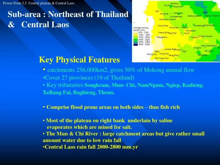
Power Point 2.3 Central plateau & Central Laos. Sub-area : Northeast of Thailand & Central Laos. Key Physical Features catchments 256,000km2, gives 30% of Mekong annual flow Cover 27 provinces (19 of Thailand)

E N D
Power Point 2.3 Central plateau & Central Laos Sub-area : Northeast of Thailand & Central Laos • Key Physical Features • catchments 256,000km2, gives 30% of Mekong annual flow • Cover 27 provinces (19 of Thailand) • Key tributaries Songkram, Mun- Chi, NamNgum, Ngiep, Kadieng, XeBang Fai, Baghieng, Theun. • Comprise flood prone areas on both sides – thus fish rich • Most of the plateau on right bank underlain by saline evaporates which are mined for salt. • The Mun & Chi River : large catchment areas but give rather small amount water due to low rain fall • Central Laos rain fall 2000-2800 mm.yr
Power Point 2.3 Central plateau & Central Laos Benefits of shared Resources • Northeast Thailand – Esaan • * Total Ag. land 58 mil rai ( 9.3 mil ha) • * 7.5 mil rai ( 1.2 mil ha) under irrigation • * Ag employs 60% Esaan labor forces • Best jasmine rice come from this region • Sticky rice for consumption, jasmine for sale • Esan produce 9.6 tons rice /yr (37% of • Thailand)
Fisheries • Capture fisheries in Song Khram, Mun and Chi consumption 36kg/per/yr • Total fish production= 777,880 kg/yr. (1992) • Songkram historically known” Padek land” • Big aquaculture potential for those alongside the rivers • Songkram River Basin: over 200 species ( IUCN)
Power Point 2.3 Central plateau & Central Laos Benefits of shared Resources • Flooding in cities, (Ubon) • Hydropower development in Mun & many other tributaries
Power Point 2.3 Central plateau & Central Laos Benefits of shared Resources • Central Laos • contain about half of Laos forest • center for food production of the country-> 4 main plains • Agricultural land is used to produce food crops.Most of country irrigated agriculture are here • compare with other riparian countries, irrigated development is limited & low capability. • Capture fishery very important. To locals this is 50% of livelihood– food, cash and means to barter for other goods. • Flood plains along tributaries, lakes, wetlands, • rich habitat & food security • High potential for hydro power
Power Point 2.3 Central plateau & Central Laos People and the shared Resources • Northeast region of Thailand • The poorest of Thailand, comprise 62% of the country poor • Population density 75-175-per.km2 , 20.6 mil people • Resources are used mainly for cash crops(fish&land) • In remote areas, resources are used for self sufficient livelihood. • Off-farm income is currently main income source since Thailand has rapid growing industry rural labour is drawn from areas.
Power Point 2.3 Central plateau & Central Laos People and the shared Resources • Central Laos • Poverty (30%) is lower than other parts of Laos, but higher than Thailand • living standard poor: malaria 72-112 per/yr, infant mortality rate 86-120/ 1000 birth, access to sanitation 4-20%, safe drinking water 40% • population density (20-70 persons/km2) 50% pop under age 14 yrs old • Resources are mainly used for self sufficient economy. • The “Breadbasket of Laos” , biggest food production. • Resources are main sources of food security.
pp2.2 Presentation Power Point 2.2 Central plateau & Central Laws Implications for Basin Planning • Northeast region of Thailand • High irrigated development leads to an expansion of irrigated land 2 risk on environmental degradation • Damming the river affects capture fish --> declining fish income and social conflict (The case of Pakmun Dam) • Rural poor & landless are venerable group in BP.
pp2.2 Presentation Power Point 2.2 Central plateau & Central Laws Implications for Basin Planning • Central Laos • Poverty reduction could be done through expansion of irrigated areas. • Laos and Thailand are energy trading partners. How to have a sound management to keep ecological balance while sustainable use of ecology.


![AFTA [ASEAN Free Trade Area]](https://cdn2.slideserve.com/3979861/afta-asean-free-trade-area-dt.jpg)