Download
1 / 1
20 likes | 196 Views
Permitting Public Health: Are Mixed Land Use Zones Improving Walkability? Carol Cannon, MA; Sue Thomas, PhD; Ryan Treffers, JD; Mallie J. Paschall, PhD; Lauren Heumann, BS; Gregory Mann, BA; Dashiell Dunkell, MS; Saskia Nauenberg, BA

E N D
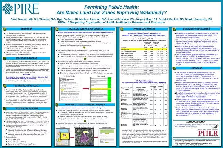
Permitting Public Health: Are Mixed Land Use Zones Improving Walkability? Carol Cannon, MA; Sue Thomas, PhD; Ryan Treffers, JD; Mallie J. Paschall, PhD; Lauren Heumann, BS; Gregory Mann, BA; Dashiell Dunkell, MS; Saskia Nauenberg, BA HBSA: A Supporting Organization of Pacific Institute for Research and Evaluation acknowledgement This research was funded by the Robert Wood Johnson Foundation’s Public Health Law Research Program. Discussion • CDC’s Healthy Places Program identifies zoning and land use as critical for healthy communities; • Zoning that segregates work, home, commercial, public and civic daily use activities perpetuates automobile use as primary transportation mode and discourages daily physical activities such as walking or biking; • Public health compromised by diminished physical activity, leading to poor health indicators--obesity, diabetes, cancer, etc. • Strategy: Implement Mixed Land Use Zones (MUZs) to shorten distance between home and daily activities. • Is this strategy working? Does mixed use zoning result in greater walkable proximity to daily use activities? • Variable: Comprehensiveness of each MUZ ordinance (adherence to APA guidelines) • Zoning ordinances from 22 California cities (populations of ≥ 50,000) collected and reviewed to identify mixed use zoning. Ordinances coded as allowing mixed use if: • One or more residential use(s) and • One or more commercial use(s) permitted or conditionally permitted. • If ordinance only permitted public/civic uses and either ≥ one commercial OR ≥ one residential uses, ordinance not coded as mixed use. • 168 Mixed Land Use Zone Ordinances identified. Each ordinance coded for 39 use measures; • Four general use categories: Residential, Public and Civic, Commercial, and Industrial. • Coded for whether use is explicitly permitted, conditionally permitted, or not permitted. • Ordinances were categorized by type of mixed use zoning mandated: • Explicitly mixed use (defined as such in wording of ordinance) • Mixed use by right (residential and commercial uses permitted without conditions) • Conditional mixed use (residential and/or commercial uses conditionally permitted) • Overlay (zone that creates mixed use by combining more than one zone type) • Other (zones that did not fit into above categories but still facilitated the mixing of uses) Legal Data: Independent Variable Preliminary results • Relationship between the comprehensiveness of municipal ordinances and the presence of daily use activities in the mixed use zones was significant. • The more comprehensive and stringent the legal scores for specific use categories, the greater the presence of these uses in the MUZs. • Analysis of legal zoning data is a feasible method for predicting neighborhood walkability. Comparative, cross-sectional research designs can complement case study and archival approaches. • This study raised the question: Under what conditions can the laws make a difference in offering walkable neighborhoods? City planners cited the economy as a major limiting factor for the development of new mixed use zones, resulting in numerous undeveloped or partially developed zones. Legal Score (Comprehensiveness of Ordinance) and Walkability Score (Percentage of Daily Use Activities Within Zones)* Methodological Goals Research Questions Can land use zoning create conditions for improved public health? Are municipal mixed use zone (MUZ) ordinances effective tools to increase walkable proximity to businesses and services, and ultimately, to improve public health? What is the relationship between MUZ comprehensiveness (defined as greater adherence to the American Planning Association’s model MUZ) and walkability* of the resulting neighborhoods? Hypothesis: Controlling for city population size and SES, the higher the MUZ comprehensiveness, the higher its walkability. * Defined as being pedestrian-friendly, pedestrian-accessible or pedestrian-oriented. • The existence of a walkable neighborhood or zone is a separate question from whether people avail them of opportunities for physical activity. Further research is needed to determine the extent to which opportunity and its use intersect. • Effective dates of ordinances are not consistently available. Some variation among results may be attributable to time between effective dates of original ordinances, effective dates of amendments to original ordinances, and/or timing of zone development. • Despite legal designations of mixed used zones, some zones identified on city zoning maps were partially or completely undeveloped at the time of data collection. • Some cities are in transition from land use-based zoning codes to form-based zoning. Form-based codes emphasize form and scale over individual use categories, and therefore score lower using this methodology. • Regional differences may also affect the results. Cities in more rural areas tend to favor horizontal over vertical mixed use development. This leads to codes that emphasize single family housing over multiple-unit or other high density residential uses. * Controlling for city SES characteristics and area of zone in square kilometers. Legal Coding Ordinance Wording Redwood City, CA CN (Neighborhood Commercial District) Zoning Code, art. 13 (2010) 13.1 Purpose To provide centers for convenience shopping in the residential neighborhood planned and controlled to the extent that such centers will perform a vital service to the neighborhoods and become integral parts thereof. (Ord. 1130, eff. 7-10-64) 13.2 Permitted Uses. The following uses are permitted in the CN District if conducted entirely within a building: A. Grocery, retail bakery sales, drug, variety or hardware stores; B. Beauty, barber, shoe, gift, stationery, record, toy or flower shops; C. Neighborhood serving, ground floor dependent offices, financial services & medical offices, subject, however, to Section 13.10 provisions; D. Soda fountains & restaurants, not including live entertainment, dancing, or sale of liquor, beer, or other alcoholic beverages for consumption on the premises; E. Studios for arts, crafts, photography & dance; F. Parking garages for customer & employee parking only; Key Markets SCORING AND ANALYSIS OLS Regression Analyses: Key Results Across Individual Equations for Subsets of Walkability* limitations To determine the feasibility of using legal zoning data to predict neighborhood walkability. This effort was designed to augment the case studies prevalent in the field which use tools such as audits of community features, public opinion and public behavior surveys, and archival data to produce comparative, cross-sectional investigations. To determine if the research design and tools available for this research produce interesting and important findings about the relationship between governmental policy and the walkability of mixed use zones within cities. Walkability data: Dependent Variable Preliminary conclusions • Variable: Number and type of daily activity uses in MUZ neighborhoods • For each MUZ type, two geographical zones randomly selected for analysis. (n=265).* • Google Earth used (key word searches, layers) to identify 43 locations and businesses constituting daily activity destinations. • Name of businesses/destinations and total number in each category recorded. • * Two geographical zones for each ordinance were not always present, hence the lower n. • Interviews with City Planners: 15 City Planners interviewed about the history and implementation of mixed use zoning in their cities. • Legal Scoring: Uses scored from 0 to 6 in each ordinance for closeness to, or distance from, APA model, taking into consideration both presence of use in ordinance and level of permission (explicitly permitted, conditionally permitted, or not permitted). Each ordinance given a final cumulative score. • Walkability scoring: Each zone measured by number and percentage of use categories present, as well as total number of businesses found. • Bivariate and multivariate analysisof relationships among legal and walkability data, including: • Correlation of ordinance’s final legal score to percentage of walkability use categories present in zone created by ordinance; • Correlation of individual legal use scores to presence of analogous walkability use activities and number of businesses in zone. • Control variables: • City population size • Socio-economic Status (SES) • Size (area in square kilometers) of each zone Zoning Map Walkability Coding Google Earth Map: “Grocery Store” Layer * Backwards stepwise regression used to determine best overall model for combined data (see previous table). The independent variables that emerged from that model [Area of Zone in Square Kilometers; Median Household Income; Race/Ethnicity: Black only; Race/Ethnicity: White only; Race/Ethnicity: Hispanic/Latino/a of any race; Race/Ethnicity: American Indian/Alaskan only; Race/Ethnicity: Pacific Islander /Hawaiian only; High School graduates (% age 25+); Graduate/Professional Degree (% age 25+); Age: 19 and under; Age: 35 to 59; Age: 60 and over] included in each of the equations pertaining to each walkability subset. ** The beta weights are included for ease of interpretation within each of these categories, not for comparison across-equations. Sue Thomas, PhD, thomas@pire.org, Carol Cannon, MA, ccannon@pire.org, Ryan Treffers, JD, rtreffers@pire.org Pacific Institute for Research and Evaluation, PIRE-Santa Cruz Office, P.O. Box 7042, Santa Cruz, CA 95061, 831-621-7937