Download
1 / 3
30 likes | 169 Views
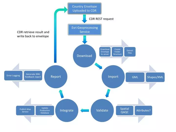
Country Envelope Uploaded to CDR. CDR REST request. Esri Geoprocessing Service. CDR retrieve result and write back to envelope. Progress Since Last Meeting. Geoprocessing Service to run spatial QAQC (e.g. http://cdr.eionet.europa.eu/at/eu/aqd/b/envurgevq /)

E N D
Country Envelope Uploaded to CDR CDR REST request Esri Geoprocessing Service CDR retrieve result and write back to envelope
Progress Since Last Meeting. • Geoprocessing Service to run spatial QAQC (e.g. http://cdr.eionet.europa.eu/at/eu/aqd/b/envurgevq/) • Solved server licensing issues for GML datasets by creating a GML import service using FME server which is called from the Esri Geoprocessing Service. • Solved Pollutant Code error caused by the xml structuring by implementing iterative attribute mapping (XML > Esri FC) in python • Published a consultation map service to enable countries to deliver better data by comparing the collective deliveries of all member states.
Next Steps. • Implement the LAU code checking methodology – either through dynamic checking of dd.eionet.europa.eu or checking against a local dataset. • Integrate with CDR for automatic service call on receiving a new envelope • Further strengthen and update attribute testing against new QAQC guidelines • Extend the consultation map service functionality: • Filtering (by Protection Target, Pollutant Code, Zone Code etc) • Possible data download to desktop function using FME