Download
1 / 20
220 likes | 361 Views
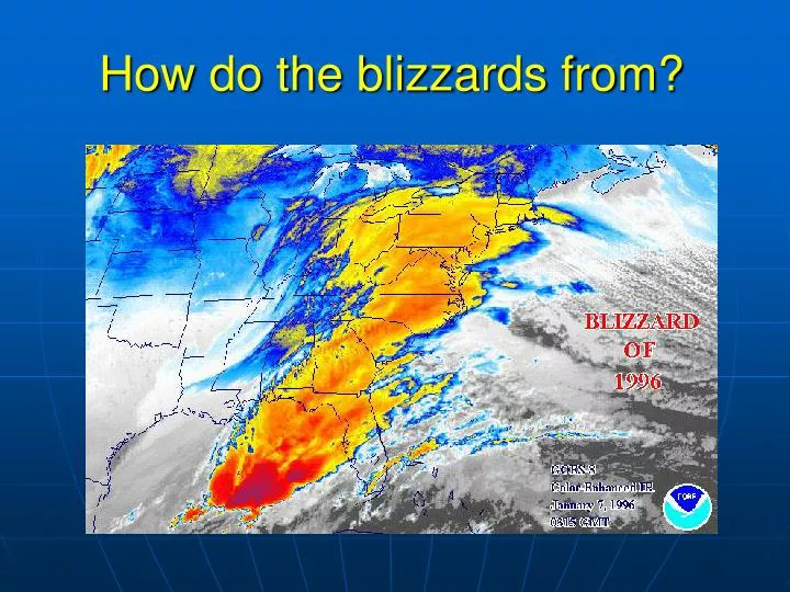
How do the blizzards from?. Review of last lecture. Definition of airmasses. Bergeron classification of air masses (3 letters) Surface weather analysis: Station model, wind speed code, present weather Fronts: 6 types. What is a cold front? Steep, narrow, fast

E N D
Review of last lecture • Definition of airmasses. Bergeron classification of air masses (3 letters) • Surface weather analysis: Station model, wind speed code, present weather • Fronts: 6 types. • What is a cold front? Steep, narrow, fast • What is a warm front? Less steep, wide, slow • What is an occluded front? Two types
Winter Storms and Blizzards (Mid-latitude cyclones) U.S. Annual mean fatalities 57, annual mean loss $329 million
What is a mid-latitude cyclone? • The mid-latitude cyclone is a synoptic scale low pressure system that has cyclonic (counter-clockwise in northern hemisphere) flow that is found in the middle latitudes (30N-55N, 30S-55S). • It has a larger size than a tropical cyclone • bring abrupt changes in wind, temperature, and sky conditions
Jet streams are caused by steep temperature gradients between cold and warm air masses Polar front - marks area of contact, steep pressure gradient polar jet stream Low latitudes subtropical jet stream Stronger in winter, affect daily weather patterns Midlatitude cyclones often form near the fronts and jet streams
Conceptual models • Norwegian cyclone model. Developed by Bjerknes in 1919, this model has formed the basis of our understanding of the life cycle of extratropical cyclones, an amazing achievement given that this conceptual model was developed during a time period of highly limited upper air data. • Conveyer belt model. Developed by Browning (1973) and Carlson (1980), this model emphasizes the sources of the incoming airstreams for an extratropical cyclone.
How does a mid-latitude cyclone form? In mid-latitude there is a boundary between northern cold air and southern warm air In the boundary a initial cyclone can advect warm air northward and cold air southward If the upper level low is to the west of surface low, the cyclone will amplify and precipitation will form. Mature stage. Cold air begins to catch up with warm air (occluded). Cold air cools down the cyclone. Dissipation.
Structure of Mature Cyclones • Well-developed fronts circulating about a deep low pressure center describe a mature cyclone. • The system is capable of creating snow, sleet, freezing rain, and/or hail. Chance of precipitation increases toward the storm center. • Heavy precipitation (thunderstorms, squall lines) stems from cumulus development in association with the highly unstable conditions in the warm sector ahead of the cold front. • Lighter precipitation is associated with stratus clouds of the warm front. • Winds, spiraling counterclockwise toward the low, change accordingly as the system, and its associated fronts, moves over particular regions.
Conveyer belt model Emphasizes the sources of the incoming airstreams
Video: The storm of 2/1/2011 http://www.youtube.com/watch?v=Vnfwr1y016Q
Why do some frontal waves develop into huge cyclonic storms, but others don’t? • Complex challenge to forecasting; • Atmospheric conditions at the surface and aloft affect cyclogenesis. • Key is to look at the upper level winds (longwaves, shortwaves).
Longwave disturbances (Rossby waves) Earth's poles are encircled by 3 to 6 longwaves, or Rosby waves, directing upper level winds around lows at the 500 mb surface. Small disturbances in these waves can trigger storms.
Shortwave Disturbances Shortwave ripples within the Rossby waves move faster, and propagate downwind into the Rossby troughs and cause them to deepen. Barotropic conditions, where isobars and isotherms are parallel, then degenerate into a baroclinic state where the lines cross and cold or warm air is advected downwind.
Regions of cyclogenesis and typical tracks • Gulf of Mexico, east coast • Alberta Clipper from eastern side of Canadian Rockies • Colorado Low from eastern slope of American Rockies • Lee-side lows, lee cyclogenesis
Snow Distribution • Snowfall distribution in North America is related to north-south alignment of mountain ranges and the presence of the Great Lakes.
Lake effect • Lake effect snows develop as the warm lake waters evaporate into cold air. • Topographic features aid downwind snow development.
Anticyclones, heat waves and droughts • Anticyclones are associated with clear skies and calm conditions. • If anticyclones linger over a region, it can lead to heat waves and/or droughts. • Anticyclones are responsible for the Santa Ana wind conditions over the west coast, US.
Climate Change and Midlatitude Cyclones • Midlatitude cyclones are associated with the polar front and polar jet stream. • It’s important to consider if climate change will cause a shift in the average tracks of midlatitude cyclones. • Recent studies have shown that the average tracks for midlatitude cyclones has shifted towards the poles. • The IPCC believes that continued warming and climate change will continue to move the tracks of the midlatitude cyclones towards the poles. This will have serious climate consequences to the Earth.
Summary • The developmental stages and vertical structure of middle latitude cyclones (boundary between northern cold air and southern warm air,upper level low to the west of surface low) • How upper level longwaves and shortwaves may enhance cyclonic development at the surface (upper level low to the west of surface low) • The three regions of cyclogenesis and typical tracks • Lake effect • Anticyclones, heat waves and droughts • Climate change: move the tracks of the midlatitude cyclones towards the poles