Download

1 / 10
100 likes | 108 Views
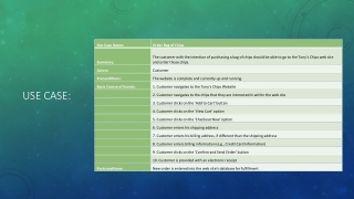
This use case involves users entering a place name to search for, selecting the type of place and state/territory to search in, and displaying the results. Users can access detailed metadata or a full listing of information about the point and place name on a map. The system aims to provide detailed data about the place name, not being dependent on other services being in place.

E N D
2) User selects the type of place (feature type) they are looking for from drop down
3) User selects the state/territory that they would like to search in
Locality 4) Results of search are displayed in a page NB In new system full feature types will be show, not codes
5) User can click through on detailed metadata of custodian or status information
6) Or user can click through on name to get full listing of information about the point and the place name located on a map
Up to this point pretty much exactly the same as the current Place Names system The next slides represent the “where we want to be” use case with jurisdictions serving out more detailed data about the place name. Of course there are potentially a lot more use cases for this stuff but this is what we’re aiming for in this project – it gives GA something to achieve for its internal project while not being dependent on other services being in place
Get Extended Data 7) User can click on “Get Extended Data”
Get Extended Data Status: Assigned 30th May 2003 Local Government Authority: Great Lakes Approx. Parish: Nerong County: Gloucester Description: A locality about 3 km ENE of Conger Hill and about 2 km S by W of Renwicks Sugarloaf. An address locality. Boundaries in Great Lakes Council area Gaz 30 May 03 see map GNB3767. 8) User gets back detailed data on the place name returned from State/Territory/AAD – what is returned will be dependent on the data available from the states and will generally be as complete as possible (don’t want it to overlap with what is already there)