Download
1 / 14
170 likes | 792 Views
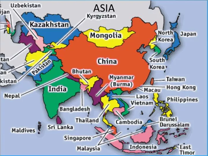
ASIA. Physical Geography. South Asia. Includes the countries of: India, Pakistan, Nepal, Sri Lanka, Bhutan, Bangladesh and Maldives. Landforms. India is a sub-continent Himalaya Mountains—highest mountains in the world Mt. Everest—highest peak in the world located in Nepal (29,000 ft)

E N D
South Asia • Includes the countries of: India, Pakistan, Nepal, Sri Lanka, Bhutan, Bangladesh and Maldives
Landforms • India is a sub-continent • Himalaya Mountains—highest mountains in the world • Mt. Everest—highest peak in the world located in Nepal(29,000 ft) • Khyber Pass—used to be the only crossing into India and Pakistan
Major River Systems • Ganges River—sacred river of Eastern India • Fed by the snowcapped Himalayas • Annual flooding during monsoon season • Empties into the Bay of Bengal • Indus River—flows mainly through Pakistan • Home to the ancient Indian civilization • Empties into the Arabian Gulf
Climate and Vegetation • Tropical and sub-tropical in the East (Indian Rainforest) • Dry in the West • Great Indian Desert • Monsoons—Seasonal winds (wet, dry and cool seasons) • Wet season brings moisture from the sea over land • Dry season blows cool air from the Himalayas
East Asia • Countries include: China, Japan, South Korea, North Korea, Taiwan and Mongolia
Islands and Peninsulas • Japan is a mountainous archipelago (4 main islands) • Mt. Fuji (dormant volcano) • Japan sits along the Ring of Fire and experiences 1000s of earthquakes and tsunamis every year • Taiwan is a former part of China • Korean Peninsula
Landforms • Several mountain ranges are located in China • The Gobi Desert is located in Northern China and Southern Mongolia
Major River Systems • Huang He River (Yellow River) runs through central China • Carries yellow top soil called loess downstream • Irrigates North China Plain • Yangtze River is located in southern China • 3 Gorges Dam
Southeast Asia • Includes the countries of: Philippines, Vietnam, Thailand, Indonesia, Singapore, Malaysia, Myanmar, Laos, Cambodia and Brunei
Landforms • There are several nations in Southeast Asia that are made up of islands: Philippines, Indonesia, Singapore and Malaysia • Malaysia is also part of a peninsula (Malay Peninsula) • The landscape is dominated by mountain ranges with volcanoes • Most of the region experiences a tropical rainforest climate
Water • This area is surrounded by many seas and oceans including: South China Sea, Philippine Sea, Celebes Sea, Banda Sea, Java Sea, Andaman Sea, Indian Ocean, Pacific Ocean, Gulf of Thailand and Gulf of Tonkin
Climate and Vegetation • Most of Southeast Asia is covered with tropical rainforest • Much of the land is dedicated to agriculture