Download
1 / 11
110 likes | 295 Views
IOOS Data Services with the THREDDS Data Server. Rich Signell USGS, Woods Hole IOOS DMAC Workshop Silver Spring Sep 10, 2013. IOOS Recommended Web Services and Data Encodings. Data Type. Web Service. Encoding. In-situ data (buoys, piers, towed sensors).

E N D
IOOS Data Serviceswith the THREDDS Data Server Rich Signell USGS, Woods Hole IOOS DMAC Workshop Silver SpringSep 10, 2013
IOOS Recommended Web Services and Data Encodings Data Type Web Service Encoding In-situ data (buoys, piers, towed sensors) OGC Sensor Observation Service (SOS) XML based on OGC Observations and Measurements (O&M) Gridded data (model outputs, satellite) OPeNDAP with Climate and Forecast Conventions DAP using Climate and Forecast (CF) conventions Images of data OGC Web Map Service (WMS) GeoTIFF, PNG etc.-possibly with standardized styles
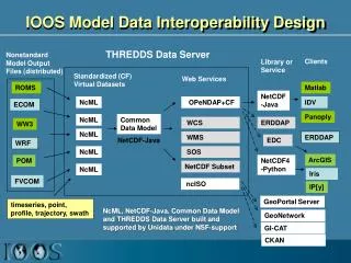
IOOS Model Data Interoperability Design THREDDS Data Server NonstandardModel Output Files (distributed) Clients Library or Service Standardized (CF) Virtual Datasets Web Services ROMS Matlab NetCDF-Java NcML OPeNDAP+CF IDV ECOM Panoply NcML Common Data Model WCS ERDDAP WW3 NcML WMS ERDDAP NetCDF-Java EDC WRF NcML SOS ArcGIS POM NetCDF4-Python NetCDF Subset NcML Iris FVCOM ncISO IP[y] GeoPortal Server timeseries, point, profile, trajectory, swath NcML, NetCDF-Java, Common Data Model and THREDDS Data Server built and supported by Unidata under NSF-support GeoNetwork GI-CAT CKAN
CDM: Scientific Feature Types • Gridded Data • Radial Data • Swath Data • Discrete Sampling Features • Point data • Station data • Profile data • Trajectory (e.g., aircraft track) data
Feature Types • point: a single data point (having no implied coordinate relationship to other points) • timeSeries: a series of data points at the same spatial location with monotonically increasing times • trajectory: a series of data points along a path through space with monotonically increasing times • profile: an ordered set of data points along a vertical line at a fixed horizontal position and fixed time • timeSeriesProfile: a series of profile features at the same horizontal position with monotonically increasing times • trajectoryProfile: a series of profile features located at points ordered along a trajectory
Setting up THREDDS catalogs • Examples of setting up model output • Example setting up time series data • Where to document THREDDS/NcML best practices and examples? • Let’s try github and gis.stackexchange.com