Download
1 / 16
160 likes | 316 Views
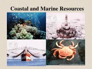
THE COASTAL RESOURCES OF THE NORTHERN RANGE. November 8-10, 2004 John Agard. WHAT COASTAL ENVIRONMENTS ARE IN INCLUDED?. Near-shore terrestrial: e.g. rocky and sandy shores. Intertidal: e.g. mangrove forests, ports and marinas Benthic:e.g. seagrass beds, coral reefs, soft bottom environments

E N D
THE COASTAL RESOURCES OF THE NORTHERN RANGE November 8-10, 2004 John Agard
WHAT COASTAL ENVIRONMENTS ARE IN INCLUDED? • Near-shore terrestrial: e.g. rocky and sandy shores. • Intertidal: e.g. mangrove forests, ports and marinas • Benthic:e.g. seagrass beds, coral reefs, soft bottom environments • Pelagic: e.g. fisheries
MAJOR DRIVERS OF CHANGE WHICH AFFECT COASTAL RESOURCES OF THE NORTHERN RANGE • Urbanization on the coast which targets flat land for ports, houses, industry, hotels, recreation. • Pollution from land based sources especially sewage, litter • More efficient fish harvest technology e.g. long-lining, trawling, gill-netting
SUMMARY OF CONDITION AND TRENDS IN COASTAL ECOSYSTEM SERVICES
Mangrove Forests Size (ha) North Coast Scotland Bay<1 Maracas Bay25 Tyrico Bay1 Las Cuevas3 Yarra River1 Marianne River15 Grand Riviere1
Size (ha) North East Coast Matura River5 Salybia4 NorthWest Coast Bayshore / Diego Martin River <1 Chaguaramas<1 Hart's Cut<1 Cuesa River<1 Mucurapo3 Sealots<1
Mangrove Forests • Northern Range has about 60 ha of mangrove forests remaining and declining • Major driver is changes in coastal land use. • Tradeoffs: water purification, fish nurseries, coastal stability
Beaches • According to IMA the north coast is less susceptible to erosion than other coastal areas, which consist of soft, friable sedimentary material. • The main problem reported is litter deposited by recreational users
Seagrass • Patches of seagrass remaining at William’s Bay, Trinidad and Tobago Yacht Club and Salybia. • Trend: area of seagrass is stable.
Coral Reefs • Small reefs exist at Toco and the five islands. • No recent assessments of condition done.
FISH CATCHES • According to Fisheries Division statistics, fish catches mainly landed at Maracas on the north coast, have increased 8 fold from about 50,000 kg in 1998 to 400,000 kg in 2001 worth about 2 million TT$. • The statistics do not include the significant fish catches which are landed in Venezeula.
PROVISION OF SAFE AND NATURAL HARBOUR AT CHAGUARAMAS • 65 yachts 1990 increased to 2590 yachts by 1997. • US$ 340,00 per month spent by yachties. • 60 million TT$ invested in associated facilities. • 1300 full time and 145 part time jobs created in 1997.
Water Quality • Sporadic studies of water quality indicate declining water quality at popular bathing beaches mainly due to increased sewage contamination. • IMA studies have established a link between bathing in sewage contaminated water and increased incidence of associated gastro-intestinal illnesses.