Download
1 / 23
230 likes | 381 Views
Determining the Granularity and Randomness of Burned Areas from Prescribed and Natural Fires. Robert Kremens 1 , Anthony Bova 2 , Matthew Dickenson 2 , Jason Faulring 1 , Colin Hardy 3 , Anthony Vodacek 1 1 Rochester Institute of Technology 2 USDA Forest Service Northeast Research Station

E N D
Determining the Granularity and Randomness of Burned Areas from Prescribed and Natural Fires Robert Kremens1, Anthony Bova2, Matthew Dickenson2, Jason Faulring1, Colin Hardy3, Anthony Vodacek1 1Rochester Institute of Technology 2USDA Forest Service Northeast Research Station 3USDA Forest Service Rocky Mountain Research Station
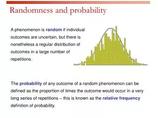
ABSTRACT Forested areas that have burned naturally without interference from man (fire suppression) show a marked variation in the size, shape and location of burned versus unburned areas. In order to achieve the goal of restoring landscapes to pre-suppression conditions, it is necessary to determine if prescribed fire produces similar patterns of variability and randomness as ‘natural’ fires occurring in unsuppressed areas on a landscape scale. Understanding and quantifying the variations in landscapes can be performed using several classification machine vision techniques that have been developed for other purposes. We use a time-resolved multi-band remote sensing technique to observe fires using the WASP airborne imaging platform, which gives us the ability immediately after a fire to determine which areas have not burned (i.e., insignificant thermal flux emitted). We can then measure the variability produced by prescribed fires and compare this to the variability produced by natural fires in unsuppressed areas. We show results for prescribed fires in Ohio. The patterns obtained from natural fires and our subset of prescribed fires are markedly different, and suggest that new ignition methods or lighting patterns may be required to obtain ‘natural’ burning patterns during prescribed fire treatments. We will discuss future plans for experiments over varied forest types in the continental United States. This work was supported by the National Aeronautics and Space Administration under Grant NAG5-10051 and by the USDA Forest Service under Joint Venture Agreement 03-JV-1222048-049 with the Rocky Mountain Research Station.
Objectives • Describe the motivation for this work • Describe the experimental technique, including the airborne and ground based data collection systems • Describe the image analysis methods • Claim success for our method! • Explain what we missed because of a slow fire season
Motivation for this research • We need to know whether the heat and fire effect patterns for prescribedfires are similar to wildfires • Is prescribed fire capable of restoring a natural (pre-suppression) ecology/pattern? • Determining the scale and pattern of unburned and heat-affected areas is laborious using field techniques • Field methods may be spatially inaccurate • Single overhead images are snapshots of an instant in the time history of the fire and do not represent total heat output • Post fire VIS-NIR images do not capture understory fires or lightly affected regions and do not tell fire intensity directly • Time-series infrared images captured over the complete course of the fire can determine the heat release patterns
Secondary goals • Validate airborne flux measurement against ‘known’ fire observables like ‘fuel burn-up’ • Verify usefulness of ground sensors as in-situ calibration devices for airborne data collection • Learn the SNAFUs
We combine overhead and ground based data collection to measure total fire energy output • Aircraft cameras sample ground at the same point as ground sensors • Clocks are synchronized on aircraft and ground (GPS clock) • Deploy several (2-5) of these ground sensors per fire
Collection method and processing chain • Capture a time series of airborne IR images (using WASP imager) • Simultaneously capture ground calibration data and burn plot samples (pre- and post- fire) • Geo- and ortho-rectify images, create mosaics • Mask areas not matching 0-heat boundary conditions • Time integrate images to produce total flux map where L = sensor radiance, Dn = digital data from detector, Dt = time interval between frames, C = calibration derived from ground sensors, f = frame number, n = total number of frames
Collection method and processing chain (2) 6.Calibrate image data using ground sensors (surface-leaving flux may be obtained from sensor-reaching radiance) 7. Analyze fire patterns using established means (e.g. FRAGSTATS) 8. Compare with extensive field sampling of fuel consumption and visual post-burn condition
A little bit about the WASP camera COTS High Performance Position Measurement Measurement Accuracy Position 3 m Roll/Pitch 0.03 deg Heading 0.10 deg • COTS Camera for VNIR • Proven aerial mapping camera • 4k x 4k pixel format • 12 bit quantization • High quality Kodak CCD 1.5 km at nadir • COTS Cameras for SWIR, MWIR, LWIR • Rugged industrial/aerospace equipment • 640 x 512 pixel format • 14 bit quantization • < 0.05K NEDT 6 km swath from 3 km (10kft)
WASP has detected a 15 cm charcoal test fire at 3300m AGL LWIR MWIR SWIR
Typical WASP ortho- and geo- rectified data product (LWIR Tmax = 800C)
WASP II quick facts • Resolution at 1500m AGL – 2m IR, 0.3m VIS • Bands: visible (RGB or color IR) 0.9-1.8mm, 3-5mm, 8-11mm • Frame rate: 0.5 Hz Vis, 30 Hz IR • 14 bit dynamic range ~ 12 ½ bit effective • View Angle, 50o fixed, 110o scanning • Coverage @ 120kts @3100m AGL: 100,000 ac/hr • NEDT: measured less than 0.05 K in MWIR • Absolute geolocation accuracy~10m • Geolocation repeatability: ~1.5m
The ground based IR flux-weather stations used to calibrate the airborne sensor and obtain in-fire weather data for fire behavior calculations The WASP airborne sensor mounted in the aircraft
A little bit about the ground sensors… • In this experiment, the ground sensors allow us to calibrate absolutely and remove the effects of atmospheric absorption • Used for experiments on 6 fires • Measure weather and infrared flux, optionally several other variables • We have measured key factors for IR remote sensing: burn scar cool down rate, surface flux (outward), emissivity • In-fire weather has been measured, showing interesting weather phenomena during flaming front passage
The ground sensors were used to absolutely calibrate the airborne images. .
The Vinton Furnace, OH experiment • 3 ½ hour fire duration, ~25 over flights by WASP sensor • 40 ground truth stations (manually sampled before and after) • 3 WX/fire intensity calibration stations • Two line ignition (upper and lower line), hilly terrain • Maple/oak/hickory forest, open with leaf duff and
Time Resolved Imaging Example • Five image sequence from prescribed fire in Vinton Furnace OH Images centered on a flux-weather station • Line ignition from top and bottom • Fire coalesces on sensor package near center of image • Time resolved flux measured from image and flux-WX station • Time integral shows fire effects Integral Fire Intensity
Fire intensity/severity map from the time integral of a 10 exposure sequence
Discussion • Definite patterns generated by ignition torches/method • Highest heat areas tended to be nearest ignition line • Good agreement was obtained with fuel burn-up and other measures of fire intensity on ground truth • Longest ‘run’ had the most uniform and lowest intensity fires
Sanity check: airborne imaging achieved 100% agreement with ground sampling for unburned regions
Conclusions • It appears that prescribed fire intensity (heat release) is strongly spatially correlated to ignition patterns • Patterns generated by point ignition (lightning) may be different form line ignition, and heat release (effects) may be significantly different • We may not be simulating ‘historical’ fire patterns with prescribed fire using line ignitions • We obtained proof of the utility of time-sequenced images for rapidly obtaining burned/unburned area maps • We have developed reliable in-fire calibration techniques for overhead IR imagery using fire resistant data loggers
Future Directions • Obtain heat pattern from point ignition prescribed fire or freely propagating wildfire • Collect data in many different forest/land cover types • Continue checking ground sensor/airborne method for absolute heat flux measurements
References: • WASP- A high performance, multi-spectral airborne imager for wildland fire detection, R. Kremens, D. McKeown, J. Cockburn, J. Faulring, D. Morse, H. Rhody, M. Richardson, presented at the 2nd International Wildland Fire Ecology and Fire Management Congress, Orlando, Fl, November 2003 • Autonomous field-deployable wildland fire sensors, R. Kremens, J. Faulring, A. Gallagher, A. Seema, A. Vodacek, Int. J. of Wildland Fire, 12, 237-244 (2003) • Measurement of the time-temperature and emissivity history of the burn scar for remote sensing applications, R. Kremens, J. Faulring, C. Hardy, presented at the 2nd International Wildland Fire Ecology and Fire Management Congress, Orlando, Fl, November 2003 Contact Information Robert Kremens Rochester Institute of Technology 54 Lomb Memorial Drive Rochester NY 14623 585.475.7286 kremens@cis.rit.edu