Download
1 / 22
240 likes | 433 Views
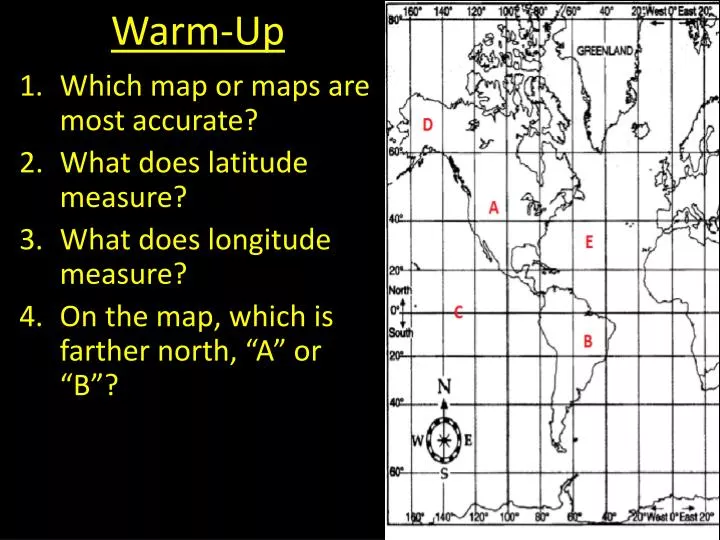
Warm-Up. Which map or maps are most accurate? What does latitude measure? What does longitude measure ? On the map, which is farther north, “A” or “B”?. What is TOPOGRAPHY?. Topography is the physical and natural features of a land

E N D
Warm-Up • Which map or maps are most accurate? • What does latitude measure? • What does longitude measure? • On the map, which is farther north, “A” or “B”?
What is TOPOGRAPHY? • Topographyis the physical and natural features of a land • A topographic map shows the different elevation over land including natural features (such as elevation) and man made features (such as schools)
Contour Lines • Contour linesare imaginary lines that represent a certain height or elevation. They connect points of the same elevation. • Contour lines will never cross orintersect another elevation • Each contour line only represents one elevation
Contour Lines and Elevation • Distance between contour lines: • Far apart = gentleslopes (rolling hills) • Close together = steepslope (cliffs or steep mountains)
Contour Interval • Contour intervalis the difference in elevation between any two points • Shows the change in height
Contour Lines and Elevation • Imagine a picture of a mountain and then imagine there were lines drawn around it every 20 ft. • What would the mountain with the lines look like if you stood on the side of it? • What would the mountain with the lines look like if you were looking down on it from an airplane?
Contour Lines and Elevation depression contours: a contour line with hachures (dashed lines) to indicate DECREASING elevation.
But first a little history… • Angel Island is a small island in San Francisco Bay • It was an Army base for much of the 19th and early 20th centuries • Known as the “Ellis Island of the West,” the immigration station for foreigners, mostly Asians, seeking to live in the United States • Currently a California State Park and popular hiking destination for locals and tourists
Practice • Work with your partner or individually to complete your Topographic Maps practice problems
Real Map Questions • Which map do you have? (Hint: look in the top right, it will say _______ Quadrangle) • What are two observations you can make about your map? (What are two things you see?) • What is the highest elevation you see? • Are the contour lines close or far apart?
Map Quiz. . . Good Luck P.S. You can use your notes on the quiz
Map Quiz • What degree latitude is the equator on? • Starting at “North” and going clockwise (to the right) what are the other directions? • Which map or maps are most accurate
Map Quiz 4. Name 2 ways maps can be helpful. 5. What are 3 things you might/ should find on a map? 6. What do topographic maps show?
Map Quiz 7. Is “A” north or south of the Equator? 8. Is “E” to the east or west of “D”? 9. What are the coordinates of “B”?
Map Quiz 10. What is the highest elevation on this topographic map, and which hill is taller?
Bonus Steps: Draw a map of Independence You get more points for more detail, and to get full credit make sure you include everything a map needs
BB= 50 ft.= 50ft. Map 1: Contour Interval= 10 ft.Map1: Contour interval = 10 ft. C =C= 60 ft60ft. Exit Ticket 1. What kind of information can be gathered from a topographic map? 2. On a topographic map, what does the contour line represent? #3-5 Use the map below: 3. According to the diagram, what is the approximate difference in elevation between point A and point B? 4. What is topographic point 1 actually displaying, based on the elevation levels? 5. According to the diagram, what is the highest point of elevation on the map?