Download
1 / 28
280 likes | 286 Views
Learn about weather and wind, including what causes wind, how wind forms, the impact of uneven heating and Earth's rotation, global wind belts, circulation cells, calm regions, and the role of wind in travel.

E N D
What is Weather? • Weather is the condition of Earth’s atmosphere at a particular time and place. What is Wind? • Wind is air moving across the surface of the Earth. It can move horizontally or parallel to the ground. Bill Nye- Wind
What causes wind? • Uneven heating of the Earths surface causes air pressure to differ from place to place. • This difference in pressure sets air in motion. Air moves from places of higher air pressure to areas of lower air pressure. This is wind!
How Wind Forms • Sunlight strongly heats an area of the ground. The ground heats the air. The warm air rises, and an area of low pressure forms. • Sunlight heats an area of ground less strongly. The cooler, dense air sinks slowly, and an area of high pressure forms. • Air moves as wind across the surface, from higher towards lower pressure.
Why does the Sun heat the Earth unevenly? • Since the Earth is round, the suns energy does not evenly reach and heat the Earth. • Sunlight is concentrated near the equator because it strikes it directly. • Sunlight is more spread out near the poles because it strikes at a lower angle.
The Earth is heated unevenly, so what? • Uneven heating between the equator and the poles causes global winds. • Since the Earth is round, the sun’s energy doesn’t evenly reach and heat the Earth. • Sunlight is concentrated near the equator because it strikes it directly. Warm air rises, producing low pressure.
The Earth is heated unevenly, so what? • Sunlight is more spread out near the poles because it strikes at a lower angle. • Because less sunlight reaches here, the air is cooler and denser. • The sinking dense air produces high pressure that sets global winds in motion.
How does Earth’s rotation effect wind? • If Earth didn’t rotate, global winds would flow directly from the poles to the equators. • But Earth’s rotation changes the direction of the wind. This is called the Coriolis Effect. • Global winds curve as Earth turns beneath them. • Winds in the Northern Hemisphere curve to the right. • Winds in the Southern Hemisphere curve to the left. • The Coriolis Effect is only noticeable for winds traveling long distances.
Coriolis Effect http://www.youtube.com/watch?v=7TjOy56-x8Q
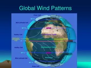
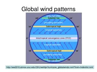
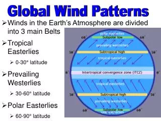
What are Global Winds? • The distances winds travel varies. • Some winds die out quickly and travel short distances. • The winds that travel thousands of miles and are able to last for weeks are called Global Winds. • The Coriolis Effect prevents the winds from flowing directly from the poles to the equator, causing them to move in three routes, called global wind belts. http://www.youtube.com/watch?v=jLiDZOqFqD8
Circulation Cells • A giant loop of moving air. • Includes a wind belt and the calm regions that border it. http://www.youtube.com/watch?v=6lqWE74ve5U
Wind Belts • Dense air sinks in high pressure areas and it flows out to areas of low pressure. • This pattern produces three global wind belts in each hemisphere. • Because of the Coriolis Effect, winds curve toward the east or west. Some global wind belts are named for the direction from which they blow.
Wind Belts • Trade Winds- • Blow from the east • Move from the horse latitudes toward equator • Strong and steady but die as they reach equator • Westerlies • Blow from the west • Move from the horse latitudes toward the poles • Bring storms across much of US • Easterlies • Blow from the east • Move from polar regions toward mid-latitudes • Stormy weather often occurs when cold air of easterlies meets warm air of westerlies
Calm Regions • Earth’s rotation and uneven heating of its surface cause a pattern of wind belts separated by calm regions. • Each calm region is a zone of either high or low pressure. • Winds are light and they often change direction. • Doldrums- low pressure zone near equator. • Warm air rises to top of troposphere • Air spreads out towards poles • Rising, moist air produces clouds and heavy rains • Heavy evaporation from warm ocean water fuels tropical storms • Horse latitudes- high pressure zones 300N and 300S of equator • Warm air traveling from equator cools and sinks here • Weather tends to be clear and dry
Model of the Earth with all wind belts, convection cells, and calm regions.
Wind and Travel • Sailors have sought out and relied on global wind belts for centuries, using the trade winds to move from Europe to N America, and the westerlies to return home. • Air travel time can be lengthened or shortened by jet streams.
Not all winds travel along Earth’s surface! • Jet Streams are long-distance winds that travel in the upper troposphere. • They travel long distances from west to east. • They travel at 124 miles per hour! Yep, that’s fast. • Form due to uneven heating of Earths surface, like global winds. • Flow in a wavy pattern around the Earth. • Each Hemisphere has two. • Affect air travel times. Usually flow 6-9 miles above Earth’s surface- airplane travel times can be lengthened or shortened by jet streams.
Types of Jet Streams • Polar Jet Streams- flow closer to the poles. • Pull cold air toward Equator and warm air up toward poles. • Strong storms form along its loop. • Have strong influence on N America’s weather • Subtropical jet streams- flow closer to equator. http://www.youtube.com/watch?v=CgMWwx7Cll4
The Gulf Stream • Warm Atlantic Ocean current traveling north • Influences climate of N America’s east coast and Europe’s west coast. • The warm Gulf Stream waters from FL combine with the cold winds from the north. This brings dense fog and immense heat transfer causing intense storms.
The Gulf Stream http://www.youtube.com/watch?v=m-zO8L66uyg
Local Winds • Change daily within a regular pattern and blow within small areas. • Sea breezes and land breezes occur near shorelines. • Sea breezes- During the day, land heats up faster than water. Air over the land rises and denser ocean air (high pressure) moves toward the area of low pressure. • Land breezes- During the night, land cools faster than water. Warm air rises over the ocean and cooler air flows in, producing a land breeze.
SEA BREEZE • LAND BREEZE http://www.youtube.com/watch?v=ZQV72Yzmjyc
Valley/Mountain Breezes • Mountain slopes heat up and cool faster than the valleys below them. • During the day, valley breezes flow up mountains- mountain breezes • During the night, mountain breezes flow down into valleys- valley breezes
http://www.youtube.com/watch?v=MNJ9A3x4rAY Monsoons • Winds that change direction with the seasons. • Caused by different heating and cooling rates of land and sea. • Winter monsoons occur in areas where land becomes much cooler than the sea. High pressure builds over the land and cool, dry winds blow out to the sea. • Summer monsoons occur when land becomes warmer than the sea. Moist wind blows from the sea over the land, bringing heavy rains. • Most extreme monsoons occur in S and SE Asia. Farmers depend on this rain to grow their crops!