Download
1 / 37
380 likes | 573 Views
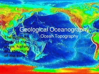
Geological Oceanography. Mapping the Oceans. Cartography – the science of making maps Dry land forms are mapped using topography . Underwater landforms are maps using bathymetry . Continental Drift. Sir Francis Bacon (1600s)and Leonardo DaVinci (1500s )

E N D
Mapping the Oceans • Cartography – the science of making maps • Dry land forms are mapped using topography. • Underwater landforms are maps using bathymetry.
Continental Drift • Sir Francis Bacon (1600s)and Leonardo DaVinci(1500s) • Noticed that the continents seemed to fit together like a puzzle • Alfred Wegener backed up idea with evidence: • Coal deposits and other geological formations across oceans matched • Fossils of a land reptile across oceans also matched • Fossilized tropical plants in Antarctica
Modern Theory of Plate Tectonics: • Crust is broken up into lithospheric plates that move on top of the mantle. • The plates move because of convection currents in the mantle.
Evidence for plate tectonics found on the sea floor. • 1. Orderly pattern of oceanic ridges and volcanoes suggesting the Earth’s crust is divided into sections. • 2. Sediment samples – the layers were thin or absent at the oceanic ridges, and thicker away from the oceanic ridges. This suggests newer crust at the ridges.
Pacific Ring of Fire • Zone along the edge of the Pacific Ocean that has many volcanoes and earthquakes. • This horseshoe-shaped belt stretches about 25,000 miles.
Evidence for plate tectonics • 3. Radiometric datingwas used to determine the age of rocks. Scientists have found seafloor rock to be significantly younger than rock in the center of the continents. • 4. Magnetometer data-This instrument measures the polar orientation of magnetism of minerals. A symmetrical pattern exists in the magnetic alignment in seafloor rock. This pattern radiates outward from the point of seafloor spreading.
Characteristics of the crust affect the influence of tectonic forces.
Oceanic vs. Continental Crust • Oceanic Crust • Denser, thinner and younger than continental crust • Oceanic crust lies lower on the mantle because of increased density. • Continental Crust • Lighter, thicker and older than oceanic crust • Continental crust rises higher above mantle because of lesser density.
Continental Margins • These are the areas of the edges of the continental crust that are under water • 2 subdivisions: Continental Shelf and Slope
Continental Shelf • Shallow extension of the continent • Can be narrow, quickly becoming steep • Or can be broad, gently sloping downward • They look much like the continent from which they extend: hills and depressions • The sediment on the shelf is eroded dirt and debris from the dry land above it • Sediment is rich in minerals, oil and gas
Continental Slope • The transition between the shelf and the deep-ocean floor • The shelf break marks the transition • Very steep • Continental rise is past the slope • It is oceanic crust covered with sediment from the land
Submarine Canyons • These canyons cut into the continental shelf and slope, ending in a deep-sea fan • Sometimes they extend from the mouth of a river that drains sediment and fast flowing water out to sea • Created by erosion like canyons on land • Sometimes they are created by earthquakes that cause an “avalanche” of sediments
Geologic features on continents and the seafloor are created by tectonic activity at the boundaries between plates.
3 Types of Tectonic Plate Boundaries • At a spreading or divergent boundary, two plates are moving apart. As this happens, the crust pulls apart and forms valleys. Magma flows up through the rift valleys creating new crust and widening the seafloor. • At a colliding or convergent boundary, two plates push together. • Movements along these destroy or recycle crust. • At a transform boundary or fault, two plates slide past each other.
Divergent Boundary • Mid-ocean ridges and rift valleys mark divergent boundaries. • Cause seafloor spreading • Volcanoes along oceanic ridges • Only one island: Iceland
Formed by divergent boundaries: Oceanic Ridges • A chain of mountains formed during seafloor spreading. • Composed of “new” basaltic rock with no sediment • If they extend above the water, they are called islands
Formed by divergent boundaries: Seamounts and Guyots • Seamounts are volcanoes that are below ocean surface • Guyots are flat-topped seamounts that once went above the ocean surface • flattened by waves and erosion
Convergent boundaries Oceanic-Oceanic Causes underwater volcanoes and island formation. Continental-Continental collide and “push together” forming mountain chains Example: Himalayas
Convergent boundaries Continental-Oceanic The oceanic plate is subducted underneath the continental plate As plate moves down into mantle it melts Increased magma is forced up through surface forming land volcanoes Example: Mount St. Helens
Formed by convergent boundaries: Trenches and Island Arcs • Trenches are deep pits in the ocean where the converging plate is subducted • Recall the cold ocean crust is sinking into the upper mantle of the continental plate • V-shaped due to spherical shape of Earth • Parallel to the side of the trench, the molten rock from the subducted plate is coming back up through volcanoes called an island arc. • Example is Caribbean islands
Snack tectonics • Divergent Boundaries: Push fruit roll-ups apart • Oceanic-Oceanic: Mid-Atlantic Ridge • Continental-Continental: Great Rift Valley, Africa
Snack Tectonics • Continental-Oceanic convergent: Colliding Graham cracker and fruit roll up • Andes Mountains, Mt. St Helens, Caribbean Islands
Snack Tectonics • Continental-Continental Convergent: Push 2 wet graham crackers together. • Alps, Himalayas, Rockies
Snack Tectonics • Transform boundaries: rub 2 dry graham crackers side by side