Download

1 / 15
160 likes | 164 Views
This workshop discusses the use of Total Precipitable Water (TPW) algorithms to estimate the amount of liquid water in the atmosphere for short-range forecasting. It explores two different approaches for TPW estimation, one for accurate surface temperature and another for uncertain surface temperature. The workshop also discusses the limitations and potential improvements in TPW estimation.

E N D
PGE06 TPWTotal Precipitable Water NWC SAF First Joint Training Workshop 14-16 June 2004 Madrid, Spain P. Fernández, J.M. Vindel
Total Precipitable Water goal • Total Precipitable Water (TPW) is the amount of liquid water, in mm, if all the atmospheric water vapour in the column were condensed. • High values of TPW in clear air often become antecedent conditions prior to the development of heavy precipitation and flash floods. • When high TPW values areas present a lifting mechanism and warm advection in low levels, heavy precipitation often occurs. • These data can provide to forecasters an important tool for very short range forecasting. • Within the SAF NWC context, the main goal is to provide TPW data in clear air pixel by pixel in image format for Nowcasting purposes.
Total Precipitable Water algorithms • The algorithms assume the lower and mid troposphere as a thick layer at temperature Tair overlying a surface with skin temperature Tsfc. • The brightness temperature T for a window IR channel observed at Zenith angle • is a combination of Tsfc and Tair weighted by the channel transmittance • which has a contribution from the carbon dioxide absorption and water vapour absorption • T = Tsfc * + Tair * ( 1 - ) (1) • Assuming the transmittance difference proportional to the water vapour content: = EXP [ - ( + * PW ) ] * sec (2) • And approximating the transmittance, assuming low carbon dioxide absorption: = 1 - * PW * sec (3) -
Total Precipitable Water algorithms Two different approaches for the estimation of the TPW can be derived: When the Surface Temperature can be accurately obtained (over SEA), by subtracting IR10.8 and IR12.0 channels brightness temperature in Equation (1) we have: T10.8 - T12.0 = ( Tsfc - Tair ) * By applying Equation (3), and assuming Tair the SEVIRI channel IR13.4 brightness temperature and Tsfc a SST obtained from a Split Window algorithm, the TPW algorithm becomes the Split-Window Difference Algorithm called SD algorithm: TPW = B + A * [ (T10.8 - T12.0) / (SST – T13.4) ] * cos (4) -
Total Precipitable Water algorithms 2. When the Surface Temperature accuracy cannot be assured, using Equations (1) and (2) applied to the IR10.8 and IR12.0 channels and eliminating Tsfc, the difference in brightness temperature is related to the differential absorption projected along the Zenith angle: ( T10.8 - Tair) / ( T12.0 - Tair ) = EXP [ ( + * PW ) * sec ] Assuming Tair the SEVIRI channel IR13.4 brightness temperature, the resulting algorithm for TPW over LAND called Logarithm Ratio or LR Algorithm is: TPW = B + A * LN [ (T10.8 – T13.4) / ( T12.0 – T13.4) ] * cos (5) -
Total Precipitable Water algorithms Coefficients have been obtained with real SEVIRI data from October, November and December 2003 using Radio Soundings for LAND and ECMWF data for SEA • Land Algorithm: TPW (mm)= B + A * LN [ (T10.8 – T13.4) / ( T12.0 – T13.4) ] * cos With coefficients: • Sea Algorithm: TPW (mm)= B + A * [ (T10.8 - T12.0) / (SST – T13.4) ] * cos With coefficients:
Total Precipitable Water inputs and output INPUTS: • SEVIRI data at full IR spatial resolution: T10.8 m, T12.0 m & T13.4 m • Auxiliary data: CMa, TPW (from previous slot for QC) • Ancillary data: Land/Sea atlas, Sun Zenith Angle & Satellite Zenith Angle OUTPUT: • The output is an image in HDF-5 format with TPW values in mm in clear areas and enhanced IR10.8 in cloudy areas.
TPW calibration changes impact:30th March 2004 13:45 14:00
TPW calibration changes impact: 13th May 2004 07:30 07:45 08:00
Calibration changes impact in TPW over SEA: IR10.8 22%average 60% average The variation is less than 10% over LAND
TPW examples and limitations 27th May 2004 • Sea values are mainly lower than actual • Night land values lower than actual • Higher values than actual in cloud edges 00:00 12:00
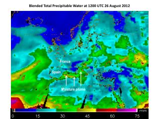
TPW examples and limitations 7th June 2004 • Very low values when dust contamination • LAND/SEA gap due to lower values over sea • Relatively high TPW values prior to convection • ECMWF TPW features mainly agrees with TPW SEVIRI data 12:00 18:00
Conclusions • The PGE06 TPW has to be re-calibrated using a full year data • Coefficients variability over LAND has to be monitored in function of • the sun zenith angle • The use of WV SEVIRI channels has to be studied • The improvement over SEA includes an improvement of the SST algorithm • (O&SI SAF) • Taking in account the current limitations, the TPW relative values obtained • can be useful in situations prior to convection