Download
1 / 28
280 likes | 286 Views
This presentation discusses the master plan for the Pittsford waterfront development, focusing on the history and context of the site, as well as potential recreational and residential uses. The goal is to create a proactive plan that coordinates enhanced use of the waterfront, new recreational opportunities, and a residential neighborhood, while maintaining the site's natural assets and historic character.

E N D
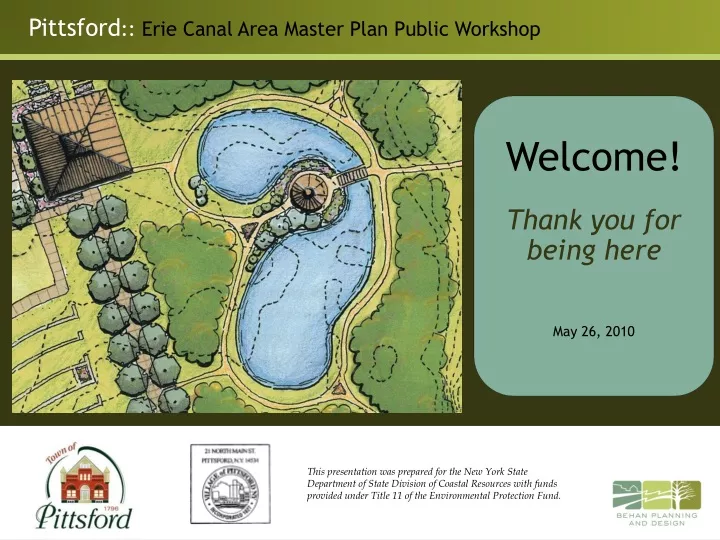
Welcome! Thank you forbeing here May 26, 2010 This presentation was prepared for the New York State Department of State Division of Coastal Resources with funds provided under Title 11 of the Environmental Protection Fund.
Tonight’s Agenda • History and Context of the Site • Brief Review of Last Workshop • Master Plan for the Site • Group Discussion • Adjourn
Property was originally zoned for Commercial / Light Industrial Village portion was zoned Light Industrial
There have been many ideas for this site: • Town Comprehensive Plan of 1995 • Town and Village Waterfront Revitalization Plan • Village Comprehensive Plan • Town community facilities committee • Town acquired property • Town (with village) secured grant funding for land acquisition and (this) planning process Concept from 2001 Comprehensive Plan
Site Context • Near the center of everything • Next to the Erie Canal • Next to Monroe Avenue • Near Main Street • At the convergence ofthe Erie Canal Trailand the Auburn Trail • < ¼ mile to 4-cornersand Schoen Place • Over 2,000 homeswithin 15 min. walk
Site Context Natural resource inventory: • site has been heavily disturbed • no significant ecological features • except wetland in NW corner Town Village Village Town
Site History Agricultural use~ 50 years ago
Site History Development of “frog ponds” by Ward’s Scientific seen in 1966 Ward’s is still around – in neighboring Henrietta
Site History By 1980 fields starting to convert to scrub land, evidence of filling and other disturbance
Site History By mid 1990’s site looks very similar to existing conditions.
Site History Existing conditions
Guiding Principles • Planning and design shall be compatible with the village’s historic character and scale. • Design the project to expand the public’s use, enjoyment, and appreciation of Pittsford’s scenic Erie Canal corridor. • Incorporate pedestrian and bicycle connections linking the site to existing trails, sidewalks, and neighborhoods. • Provide a blend of recreational and residential uses and natural resource protection.
Draft Vision Statement Take advantage of the Erie Canal setting and existing natural assets by developing a proactive plan that coordinates enhanced use of the waterfront, new recreational opportunities, and a residential neighborhood. Design improvements to be in harmony with the surrounding context, including the village, town center, and the Erie Canal.
Site Opportunity Summary Ecological Area Residential Area Park Area
Some notes from the December Workshop • Desire to maintain natural setting of the site • Must be balanced with long-planned development of the site • Maintain “ribbon of green” along canal edge • Passive recreation – not active recreation • Interest in an arboretum • Possible location for a community center • Residential development should be small-scale, well designed and tie into the rest of the Village • Grove Street neighborhood should be carefully considered as part of plan • Potential traffic concerns • Importance of plan with both short- and long-term goals
With the thoughts from the December workshop in mind, a plan was created…
Maintain a green “buffer” and wildlife corridor along the Auburn Trail
Maintain a core natural area within the site – include trails, overlooks and signs.
Provide gathering spaces – an amphitheatre, arboretum, pavilions, pond, etc.
New residential development with strong link to canal and rest of the Village – include streetscape improvements on Grove St. Note: no vehicular connection from Grove to Monroe
Dock and kayak ramp Zooming in on the “parkland” Event Pavilion New Pond with Gazebo Treelined walkway Amphitheatre TrailNetwork
Later into the future… Community Recreation Center
Sometimes these projects take a while to come to fruition Frank Lloyd Wright’s 1959 Rendering of Monona Terrace Used with permission of the Frank Lloyd Wright Foundation, Scottsdale, AZ Nearly 40 years pass….. Monona Terrace Community and Convention Center, Completed 1997
Thank you for listening – now time for discussion