Download
1 / 27
270 likes | 272 Views
This introduction provides an overview of surveying methods, including factors that influence the choice of method and the instruments used. It also discusses the importance of accuracy and referencing in surveying.

E N D
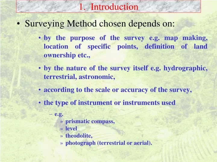
1. Introduction • Surveying Method chosen depends on: • by the purpose of the survey e.g. map making, location of specific points, definition of land ownership etc., • by the nature of the survey itself e.g. hydrographic, terrestrial, astronomic, • according to the scale or accuracy of the survey, • the type of instrument or instruments used • e.g. • prismatic compass, • level • theodolite, • photograph (terrestrial or aerial).
1. Introduction • Other factors: • Curvature of earth over 5 km, vertical angle difference will approach 2.5 minutes which can readily be detected even with most basic theodolite. • Errors collimation errors in instruments need to be calibrated otherwise “rivers could flow uphill” • Surveying involves • transfer of levels between two points • measurement of angles and lengths. • requires solution of triangular shapes using basic trigonometry • (or by graphical means). • If distances are large: planar geometry no longer applies.
1. Introduction • Geodetic surveys allow for curvature of Earth • 1:2500 scale maps actually vary in scale • On extreme east and west coasts, scale is approximately 1:2501 • Reference is taken along 2 oW where scale is 1:2499 • Along Greenwich Meridian and 4oW scale is 1:2500 • Surveying Instruments can be very accurate • Instruments in ENV are capable of accuracies of 1 part in 20000 with ease if used correctly. • Maps in UK are based on cartesian co-ordinates • North is represented by a bearing of 000. • East a bearing of 090, • South-west a bearing of 225 etc. • Referencing: True North: Grid North: Magnetic North • .
2. Basic Surveying Methods N O where is the length of the line, and is the bearing where Eo is Easting and No is Northing of the reference station. Difference in the Easting (E) is given by:- • Point location - radial line and distance method.. Northing difference (N)is given by:- True co-ordinates of the second point:- Easting = Northing = This method can ONLY be used if there is an INBUILT reference direction in the instrument - e.g. magnetic north
2. Basic Surveying Methods N R O • Point location - radial line and distance method.. • No inbuilt reference Two horizontal angles areALWAYS needed i.e. a reading to R (a reference object) as well as object of interest • Applies to most instruments: • Total Stations • Theodolites • Levels etc
2. Basic Surveying Methods A B N C B C A B C A B C D A Internal Triangle of Errors • Point location - Resection External Triangle of Errors Coordinates of A and B are known Point C found from bearings at A and B or bearings from C to A and B Methods to distribute errors are needed P
2. Basic Surveying Methods a a a b b b A1 A1 A1 c c d c A2 e • Open Traverse • Errors accumulate • Point location - Traverse Methods • Closed Traverse • Errors can be distributed • Closed Loop Traverse • Errors can be distributed
2. Basic Surveying Methods 2 1 d2 d1 A B D1 D2 • Point location - Offset Methods Useful for mapping features Not suitable where accuracy is required
2. Basic Surveying Methods • Height Measurement • Level Ground • Base Accessible • Level Ground • Base Not Accessible
2. Basic Surveying Methods ds H H • Sloping Ground • Base Accessible • Observations to same height above ground • Height Measurement • Sloping Ground • Base Accessible • Observations to different height above ground
2. Basic Surveying Methods H2 H1 • Sloping Ground • Base Accessible • Base and Top above and below observer • Height Measurement
3. Planning a Survey • Careful Planning is needed • A single missed reading will make whole survey of no value • Need to provide checks • Abstract raw data in field • Repeat readings if necessary before leaving site. • Remember an extra set of readings may take 15 minutes - but to remobilise and set up again may take many hours • schedule breaks effectively.
3.2 Basic Requirements • A clear statement of purpose of survey is needed • e.g. • mapping vegetation boundaries; estimating river bank plan shape or erosion rates; • determining flow characteristics in rivers; • establishing fixed reference stations for future use; • locating the point at which a particular set of measurements have been taken; • measurement of the profile of a slope; • assessment of regions liable to flooding. • scale of the map required (if relevant). . The purpose of the survey will dictate the scale and accuracy required and ultimately the methods to be used.
3.2 Basic Requirements • Secondary Planning Requirements include:- • what equipment is actually available • what time is available • what man-power is available • what access and transport are available. • over what distance will the surveying party be spread during the surveying? • Will it be necessary to return to the same site at a later date to take repeat measurements, and if so when (within a few days, or several weeks or months later?). • How will contact between members of the surveying team be maintained at distance?
3.2 Basic Requirements • Mapping vegetation boundaries: • accuracy ~ 1:1000 (1 m is represented by 1 mm), • Suitable surveying methods: • compass and tape traverses, • chain and offset mapping, • point resection using a prismatic compass. • height variations, Abney levels will often be adequate. • Alternative methods, if the equipment is available, • use of a surveyor's level and tachymetery, • use of electro-magnetic distance measurement.
3.2 Basic Requirements • Water Slope Measurement • Difference in water surface elevation in a river is small, • Measurement requires accurate measurement of height differences over distances which are usually between 10m and 500m apart. • A good surveying level for which thecollimation error is knownis required. • Otherwise river may appear to flow uphill!!
3.2 Basic Requirements • Fixed Control Points • Measurements will be needed to the nearest millimetre (centimetre) even if associated mapping detail is not required at this level of accuracy. • Sometimes, such as in the vegetation survey, simple methods can be used including prismatic compasses to establish stations, • Control stations will be located more accurately using a theodolite and associated equipment.
3.2 Basic Requirements ~10 - 20 m • Surveying River Banks • Methods • Radial Line Techniques using tachymetry for general plan shape of meanders (general profile ~5m). • More accurate methods involving the establishment of short permanent base lines on the bank parallel to the long stream direction of the river are needed for erosion studies. • accurate profiles of bank are determined using metre rule offsets from this reference line to the edge of the river bank. • Decisions needed • what constitutes the edge of the channel?
3.2 Basic Requirements • Size of Survey Party:- • what equipment is to be used for accuracy • access for vehicles • e.g. • a theodolite requires a tripod and targets • may also require targets mounted on tripods • could require a minimum of three tripods and ancillary equipment. • Often makes sense to establish control stations separate from detailed purpose of survey • Communication • Radios • Flags? • Markers: Permanent: Temporary????
3.3 Booking of Data • in waterproof notebooks • should be logical • should always be done in the field • if necessary it can be transcribed BUT the ORIGINAL BOOKING MUST ALWAYS be accessible. • Cross checking should be booked in field • Critical Information which should always be present • Purpose of Survey: (River Bank Mapping at Maes Mawr) • Date: Time: Weather: • Specific Location • Sketch of Area • Booker’s Name: • Observer’s Name
3.5 Treatment of Errors • Systematic Errors • collimation errors in instrucments • magnetic errors affecting all readings at a particular location • Systematic errors (unless large) can be compensated - will always be present and calibration is important. • Random Errors • observer variations in reading a scale 148.1 148.2 148.0 148.1 148.1 148.1 148.2 147.9 148.1 148.2 • Mean is 148.1 - standard deviation is 0.09
3.5 Treatment of Errors • Snedecor’s Rule Where R is range of readings
3.5 Treatment of Errors • Random Errors 148.1 148.2 148.0 148.1 148.1 148.1 148.2 147.9 149.3 148.2 • Mean is 148.22 - should this value be used? • Exclude 149.3 and mean is 148.10 • standard deviation is 0.10 • value of 149.3 is 12 standard deviations from mean and should be excluded. • Gross Errors should always be discarded
3.6 Provision of Checks • Going to repeat a survey is time consuming • Always provide a check • pace out a distance • sight on three positions rather than basic two • if measuring three stations - take readings at all three stations - sum of angles should be 180o • For Level transfers • e.g. elevation profile of longstream of river • trace river from start to finish • transfer level back along back - differences should be same • if errors are unacceptable (e.g. 20 mm per 1 km) then repeat until consistency is achieved 148.1 148.2 148.0 148.1 148.1 148.1 148.2 147.9 149.3 148.2 • Mean is 148.22 - should this value be used? • Exclude 149.3 and mean is 148.10 • standard deviation is 0.10 • value of 149.3 is 12 standard deviations from mean and should be excluded. • Gross Errors should always be discarded
3.7 An example of Bad Planning RO A B C D E Lady Bower Reservoir • ENV students doing their third year project in 1992 in Derbyshire • needed to map meanders • decided to use radial line method and tachymetry using level • measured A to RO • measured radial lines at A • moved to B • measured B to A • measured radial lines at B • moved to C • etc Despite careful planning points B, C, D and E could not be located!
3.7 An example of Bad Planning RO A B C What should have been done? Before leaving Derbyshire, map should have been plotted. Before moving from A to B measure A to B When at B measure from B to A