Download
1 / 29
290 likes | 402 Views
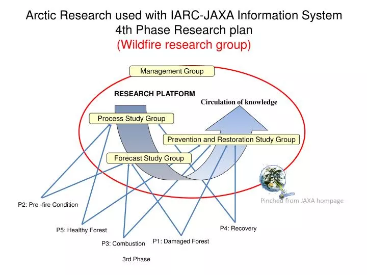
Management Group. RESEARCH PLATFORM. Circulation of knowledge. Process Study Group. Prevention and Restoration Study Group. Forecast Study Group. Arctic Research used with IARC-JAXA Information System 4th Phase Research plan (Wildfire research group). Pinched from JAXA hompage.

E N D
Management Group RESEARCH PLATFORM Circulation of knowledge Process Study Group Prevention and Restoration Study Group Forecast Study Group Arctic Research used with IARC-JAXA Information System4th Phase Research plan (Wildfire research group) Pinched from JAXA hompage • P2: Pre -fire Condition • P4: Recovery • P5: Healthy Forest P1: Damaged Forest • P3: Combustion 3rd Phase
Final Target on the 4th Generation Improving and summarizing the findings obtained during 1st and 3rd phases The results gotten by IARC-JAXA project should be published by papers and dissertations Contribute IPCC 5th, 6th AR, ICARP3 by IASC, and others via operational use by satellite and field data
Prevention and Restoration Study Group(P2) Koichiro HARADA Miyagi University
topics Our group is constructed to develop the past (and future) findings to apply the prevention and restoration of tundra and taiga. There are three applications planned. • Conservation and restoration of vegetation after severe wildfire • Producing hazard map of suspended sediment caused by thawing of permafrost after wildfire • Offering of wild fire spread forecast information
Conservation and restoration of vegetation after severe wildfire From the past studies conducted in tundra and taiga in Alaska, These are to clarify: • Relationships between successional direction and fire severity • Relationships between environmental factors and the spontaneous succession • Restoration of P. mariana forest through facilitating Sphagnumrecovery • Validation of restoration success on regional scale, by the comparison with satellite data.
We have done Summer 2006 Seed trap Germination (2006-2010) Environment Burned severity [Canopy, ground] Light (Canopy openness, Albedo) Topography / Permafrost /Moisture / Nutrients (Litter) Large-scale environmental changes remote sensing Seed immigration Seedling Emergence Survival Growth Monitoring Litter Spring Summer 2005 Spring Summer 2006 Spring Summer 2007 Biomass / Cone Summer 2008 Summer 2009 Summer 2010 Picea mariana vs deciduous trees Unburned vs Burned
What we should do (future plan) (2011-2014) • Objectives: • To detect revegetation patterns in the early stages of succession along fire severity gradient • Seed immigration and emergence were determined soon after the wildfire (confirmed by monitoring for 6 years) • Next step, we have to confirm survival and growth! • Restoration (and conservation) of ecosystems by introducing Sphagnum propagules • The restoration technique should be validated over a wide area, by using remote sensing data Additional plan Supporting the other project(s) Do you need vegetation surveys? Baby fire
Research Plan • Location Poker Flat , Seward Peninsula (Alaska) • Expected Results Conservation and restoration of Sphagnum vegetation have been controversial in boreal regions. We provide the new insights on the restoration of P. mariana forest through the introduction of Sphagnum forest floor.
Offering of wild fire spread forecast information (1) Wild fire detectionwith MODIS data analysis (2) Weather prediction simulation, (3) Wild fire expansion simulation (4) Showing the results of wild fire expansion simulation through internet IJIS (2) (3) (4) (1)
Producing hazard map of suspended sediment caused by thawing of permafrost after wildfire • To estimate an amount of soil flowed into the river or lake, which is caused by the retrogressive thaw slump after wildfire, • To clarify an impact of thaw slump to the surrounding environment.
Research Plan • 2011-2012: To build the wild fire expansion simulation in semi-real time
Selawik River suspended sediment transportation AVNIR-2 July 22, 2007
RGTS near Toolik Lake 2006 2010
Observation plan • Field observations will be conducted to measure the amount of discharged sediments from the thermokarst, and to measure the sediment transported by the river system. Traditional triangular survey will hired to estimate the volume of discharged sediments at the thermokarst site. The observation will be held in Toolik Lake, Alaska.
Research Plan • Location Toolik Lake and more…. (Alaska) • Expected Results An estimation of amount of flowing soil will be developed by using the satellite data, a hazard map can be created, and information about a disaster will be released.
Satellite data • AVNIR-2, PALSAR and PRISM, ALOS, for hazard mapping • MODIS for forecast information
(P3) Forecast Study Group Forecast Study of wild fire occurrence and environmental change caused by wildfire Hiroshi HAYASAKA Graduate School of Engineering, Hokkaido University Kita-ku, Sapporo, Japan, hhaya@eng.hokudai.ac.jp 2009 Minto Fire: Photo by Frank V. Cole
Members Group leader: Hiroshi HAYASAKA (Hokkaido Univ.) Forest, tundra, and peat fire, Hotspot, Weather • Koichiro HARADA (Miyagi Univ.) Permafrost • Yuki SAWADA(Fukuyama City Univ.)Permafrost • Kenji YOSHIKAWA (UAF)Permafrost • Cathy CAHILL (UAF) Smoke, Hotspot detection • Keiji KIMURA (Hokkaido Univ.)Fire Modeling ※ Collaboration Researchers in IARC (satellite, weather…) , GINA, & AFS (Alaska fire service)
Background Alaskan Fire History by Size North Slope, Sep. 29, 2007 Tundra Fire 1,039km2 Severe Lightning & Drought Throughout Summer 9 Large Fires (>1,000 km2) Severe Lightning & Drought Year Severe Lightning but Wet Year Minto Fire, Aug.5, 2009 Photo by Frank V. Cole
Purposes Use of satellite imagery and ground-truth measurements to enhance and improve models for determining location of fires, fire behavior (expansion, burn severity, etc.) and fire impacts on local and regional climate and global change. (1) Forecast for wild fire occurrence (2) Prediction of fire occurrence in tundra (3) Prediction of variation of active layer in permafrost (4) Determination of satellite thresholds for detectable wild fire smoke (5)Verification of wild fire occurrence model, smoke flow model, and satellite detection algorithm
1 & 2. Forecast for wild fire occurrence Hiroshi HAYASAKA (Hokkaido Univ.) 1-1. Prediction of wild (tundra) fires = forecast of lightning occurrence Forecast: Daily→ Weekly→ Monthly→ Seasonally Ordinary Cell Thunderstrom A1. Check weather and fuel conditions: ~12 am (Temp., Rainfall, weather maps….) A2. Check Lightning Forecast Index:~12 am LFI(N) = 0.7*Te850, (N-1) - LIFT (N) (N=day number) Vapor flow & Lightning Thunderclouds A3. Check satellite images: ~12 am MODIS, GEOS…. IR3 (6.5〜7.0μm) Thundercloud, vapor flow,…. ≅73% IR3 (6.5〜7.0μm) B. Prepare lightning or fire occurrence: 13~ pm Surface & Underground Fire
3. Prediction of variation of active layer in permafrost Methods: • Analysis: using data sets of thaw depth and ground temperature after forest and tundra fires. • Simulation: to show a variation of thaw depth in each fire severity, and predict a future thaw depth Y. SAWADA, K. HARADA, K.YOSHIKAWA
Yuki SAWADA (Fukuyama City Univ.) Thermal resistance of the remaining organic layer determine the thickness of active layer Active layer thickness and index of the thermal resistance of organic layer (ξ; Yoshikawa et al., 2003) . Temperature changes of active layer in Poker Flat. “High disturbance” site has large amplitude of temperature changes.
Mapping of thermal condition of permafrost after wildfire using field and satellite data Koichiro HARADA (Miyagi Univ.) • Surface roughness from field observations • Entropy from ALOS PALSAR PLR data rough: 18.7 burned smooth: 8.9 unburned Fig. Surface roughness measured in Kougarock site. Fig. Entropy image form ALOS PALSAR PLR data.
4. Determination of satellite thresholds for detectable wildfire smokeWildfire Aerosol, Satellite, and Model Integration Purpose: 1) To obtain high-quality ground and airborne measurements of aerosol size distributions and compositions for satellite smoke retrieval and smoke emission model input and validation 2) To obtain infrared and synthetic aperture radar (SAR) imagery of fire perimeters and behavior for validation of satellite fire perimeter determinations and model spread predictions Cathy CAHILL (UAF) Gregory W. Walker Figure courtesy of the Geographic Information Network of Alaska
Published Papers 1. Recent Anomalous Lightning Occurrence in Alaska – the Case of June 2005-, Murad Ahmed Farukh, Hiroshi Hayasaka, Keiji Kimura, Journal of Disaster Research, 6-3, 321-330, 2011. 2.Characterization of Lightning Occurrence in Alaska Using Various Weather Indices for Lightning Forecasting, Murad Ahmed Farukh, Hiroshi Hayasaka and Keiji Kimura, Journal of Disaster Research, Vol.6-3,343-355, 2011. Under reviewing: ??.Active Forest Fire Occurrences in Severe Lightning Years in Alaska, Murad Ahmed Farukh, Hiroshi Hayasaka, Journal of Natural Disaster Science, Vol.??-??,??-??, 201?.