Download
1 / 1
10 likes | 69 Views

E N D
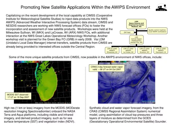
Capitalizing on the recent development of the local capability at CIMSS (Cooperative Institute for Meteorological Satellite Studies) to inject data products into the NWS AWIPS (Advanced Weather Interactive Processing System) data stream, CIMSS and NESDIS researchers are working with NWS forecast offices (FOs) to foster the incorporation and assessment of new satellite products. Workshops were held at the Milwaukee-Sullivan, WI (MKX) and LaCrosse, WI (ARX) NWS FOs, with additional interaction at the NWS Great Lakes Operational Meteorology Workshop. Another workshop visit is planned for the Green Bay FO (GRB) in early 2008. Via LDM (Unidata’s Local Data Manager) internet transfers, satellite products from CIMSS are already being provided to interested offices outside the Central Region. Promoting New Satellite Applications Within the AWIPS Environment Some of the more unique satellite products from CIMSS, now possible in the AWIPS environment of NWS offices, include: CRAS 2-day forecast water vapor valid – 06 UT on 04 Oct 2007 MODIS SST observed - 17 UT on 19 Sep 2007 High res (1 km or less) imagery from the MODIS (MODerate resolution Imaging Spectroradiomter) onboard the NASA Terra and Aqua platforms, including visible and infrared imagery, and derived product imagery, such as for sea surface temperature (SST) and vegetation index (NDVI). Synthetic cloud and water vapor forecast imagery, from the CRAS (CIMSS Regional Assimilation System) numerical model, using assimilation of cloud top pressures and three layers of moisture as determined from the GOES (Geostationary Operational Environmental Satellite) Sounder.