Download
1 / 11
130 likes | 542 Views
Map Scales. CGC1D. Introduction to Map Scales. A map scale represents the relationship between distance on the map and distance in the real world. Map scales are used to calculate: The distance between two points The size or area of a geographic feature, such as a Province, City or Lake.

E N D
Map Scales CGC1D
Introduction to Map Scales • A mapscale represents the relationship between distance on the map and distance in the real world. • Map scales are used to calculate: • The distance between two points • The size or area of a geographic feature, such as a Province, City or Lake
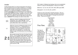
Types of Map Scales • Direct Statement Scale uses words to describe what a distance on a map represents in the real world • For Example 1 cm = 10 kilometers • To determine the distance on a map with a direct statement scale, measure the distance between the two places. Calculate the distance based on the scale. • For example, if you measured it to be 3cm between the two places, you would calculate it like so: • 1 cm = 10 km • (3 x 1) cm = (3 x 10) km • 3 cm = 30 km • Therefore, the actual distance between the two locations is 30 km.
Types of Map Scales • Linear Scale is like a special kind of ruler that is divided into units of distance • With this type of map scale, you would need to use the linear line as a reference to determine how many kilometers one cm would represent in real life.
Move the mark from step three to 0 on the line scale and measure the remaining distance Make a mark on your paper at the right end of the scale Calculate the total distance between Kingston and Cornwall by adding together the two distances you measured. The distance between Kingston and Cornwall is 180 km.
Types of Map Scales • Representative Fraction Scale is a ratio where one unit on a map represents a specific number of the same unit in the real world • 1:50 000 • For this example, 1 cm on the map represents 50 000 cm in the real world or 0.5km) Represents the distance on the map Represents the distance on the Earth’s surface
Scale Conversions 1 km = 1000m 1 m = 100 cm 1 km = (1000 x 100) cm = 100 000 cm
Converting an R.F. Scale to a Direct Statement Scale To convert an R.F. scale to a direct statement scale, divide the denominator by 100,000, to change into kilometers. Use the following process: 1 cm = 50 000 cm 1 cm = (50 000 ÷ 100 000) km 1 cm = 0.5 km or 1 cm to 500 m
Converting a Direct Statement Scale to R.F. Scale To convert from a direct statement scale back to an R.F. scale, multiply the number of kilometres by 100 000 1 cm = 2.5 km 1 cm = (2.5 x 100 000) cm 1 cm = 250 000 cm or 1: 250 000
Examples • Convert the representative fraction to a direct statement 1: 250 000 Convert the direct statement scale to an R.F. scale 1 cm to 5 km
Practice Map Scale • From your textbook: • Page 47 • Questions 1 to 10, 13