Download
1 / 11
110 likes | 274 Views
Lecture 16: GIS Database Creation and Maintenance (IV). Topics. 5. Metadata 6. Summary of Database Creation 7. Data Standards 8. NSDI. Readings on the topics. Chapter 11 in the text, pp.245-250 http://www.fgdc.gov/metadata/metadata.html (Metadata). Other readings.

E N D
Lecture 16: GIS Database Creation and Maintenance (IV) Topics 5. Metadata 6. Summary of Database Creation 7. Data Standards 8. NSDI Readings on the topics Chapter 11 in the text, pp.245-250 http://www.fgdc.gov/metadata/metadata.html (Metadata) Other readings http://mcmcweb.er.usgs.gov/sdts/ (SDTS) http://www.fgdc.gov/(FGDC and NSDI) http://water.usgs.gov/nsdi(Example of clearing house)
Outlines 5. Metadata: (Guest Lecture) What ??? (conceptual) • … the label on your Spam. • … the scrawls on your cubicle walls • …your little black book. • … ‘data about data’ , the map legend & collar • … qualifying information giving the content, condition, usefulness, accessibility and other characteristics of a discrete grouping of features with associated attributes. • Context information without which something is less discernible and less usable / useful…
Metadata: What (in GIS context) What ??? (institutional) • … contract spec.’s • … in-house methods, data dictionary • … source data (with its metadata) • … data context: project/application spec.’s • … standards & standard procedures • … agency policies and contact information
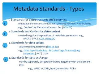
The Content Standard for Digital (CSDGM) Geospatial Metadata What ??? (practical) • … standard-compliant formatted metadata • … developed/improved/updated over time • … applicable to all spatial data collections • … extensible through profiles and standards evolution • … mandatory at some levels of government • Go see some: http://sco.wisc.edu/wisclinc/
FGDC Standard: 7 Main Sections + 3 Minor Sections 1 Identification Information 2 Data Quality Information 3 Spatial Data Information 4 Spatial Reference Information 5 Entity & Attribute Information 6 Data Distribution Information 7 Metadata Reference Info. 8 Citation Information 9 Time period Information 10 Contact Information
Mandatory Elements (The Major Sections Figure) • Citation • Description (Abstract and Purpose) • Time Period of Content (Time Period and Currentness Reference) • Status (Progress and Maintenance) • Spatial Domain • Keywords • Access Constraints • Use Constraints • Metadata Date • Metadata Contact • Metadata Standard Name • Metadata Standard Version
6. Summary of Database Creation 6.1 Database Creation Guidelines: 1) Define the scope of the database 2) Determine data model (spatial and aspatial) to use 3) Identify data sources and collect source data 4) Perform data conversion (digitise or import) 5) Perform coordinate transformation 6) Edit data 7) Verify data (a) If spatial data are complete; (b) If spatial data are in the right location; (c) If spatial data are linked to the proper attribute data; (d) If attribute data are complete and update 8) Create metadata
6.2 Building a raster database (The Raster Database Building Diagram) 6.3 Building a vector database (The Vector Database Building Diagram) 7. Data Exchange and Data Standards: 7.1 Forms of data exchanges: 7.1.1 Direct translation (Direct Translation Diagram) Factorial increase of programs with a linear increase of systems 7.1.2 Neutral exchange format (Neutral Format Diagram) Agreement on a common format (data standard)
7.2 Transfer Standards (Data Standards) 7.2.1 Spatial Data Transfer Standard (SDTS) (a subcommittee of ANSI, American National Standard Institute) (http://memeweb.er.usgs.gov/sdts) 7.2.2 Neutral Transfer Format (U,K,): 8. National Spatial Data Infrastructure (NSDI): 8.1 NSDI: Consists of policies, standards, procedures for organizations to cooperatively produce and share geographic data Federal Geographic Data Committee (FGDC) (http://www.fgdc.org) 8.2 Geospatial Data Clearing Houses: Pathways developed by individual organizations to facilitate the search for geographic data USGS clearing house: (http://water.usgs.gov/nsdi)
Questions: 1. Why do we need metadata? What are the basic aspects that metadata must cover? Who should create and maintain metadata? 2. Describe the procedures involved in creating a raster database from various sources? How is that different from the construction of a vector database? 3. Who is FGDC? What is its main task? 4. Why do we need data standards?