Download
1 / 11
110 likes | 116 Views
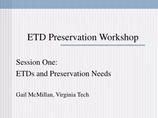
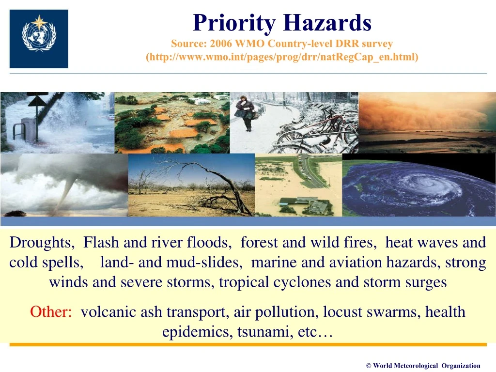
Priority Hazards Source: 2006 WMO Country-level DRR survey (http://www.wmo.int/pages/prog/drr/natRegCap_en.html).

E N D
Priority Hazards Source: 2006 WMO Country-level DRR survey (http://www.wmo.int/pages/prog/drr/natRegCap_en.html) Droughts, Flash and river floods, forest and wild fires, heat waves and cold spells, land- and mud-slides, marine and aviation hazards, strong winds and severe storms, tropical cyclones and storm surges Other: volcanic ash transport, air pollution, locust swarms, health epidemics, tsunami, etc…
About the WorkshopAgenda – Session 2 • Chair: Angelika Wirtz 1) Diversity of disaster risk assessment and analysis stakeholders and their needs (local, national, regional, global, sectoral, etc) to support a diverse range of DRR related decisions. 2) Definitions of hazards and related cascading hazards from risk assessment and analysis perspectives versus meteorological, hydrological and climate perspectives. 3) Importance of hazard definition, data, metadata, analysis and mapping for collection of loss and damage data, risk assessment and risk analysis. 4) Needs and requirements of stakeholders that carry out damage and loss analysis, damage and loss database development, risk assessment and risk analysis for hazard data, metadata, hazard analysis (historical versus forward looking). 5) Challenges with quality, availability, accessibility of hazard information at national, regional and global levels for risk assessment and risk analysis.
Issues discussed (1) • From Damage and Loss databases to probabilistic risk assessment and modeling • Highly diverse needs for risk information for decision-making: • Intra- and Inter-Sectoral risks, spatial and temporal resolutions of decision-making (local, sub national, national, regional and global) • Definitions of hazards from Risk/decision-making versus technical perspectives (sources, etc) • Impacts (loss and damage parameters, scales, quality, etc) • Institutional Issues for risk information • Capacities for development of risk information highly varied • Mandates of institutions (public, private, NGO, academic) (gaps and overlaps) • Authoritative versus research • Decision-based versus technical interest • Multiple stakeholder (supplier and users of risk info) • Partnerships and agreements among diverse stakeholder
Issues discussed (2) • Technical Issues for Met, hydro and climate community • Hazard definitions (based on risk/decision-making needs) (source and cascading hazards) (duration, severity, frequency, location) (multi-hazard and mutually exclusive) • Availability, accessibility, quality and format of hazard data and metadata (temporal and spacial resolutions) • Changing patterns of hazards (forecasting and modeling) • Institutional capacities and operational aspects • Hazard Observing networks (insitu and space) • Data management systems • Communication systems • Forecasting and modeling • Human resource at NMHS to be able to work at the cross roads of hazard and risk • Cooperation with other technical agencies un sharing data and information • Cooperation with risk assessment/modelling(engineering community
Needs and Requirements on Hazard related issues (Historical loss and damage data) Hazard Event characterization (definitions) – in terms of magnitude, duration, location, temporal and spatial variability Hierarchy of Hazards – primary large-scale and related secondary and tertiary localized hazard event identification Indexing of hazards – assignment of a standardized, unique identifying number for each event (i.e. GLIDE) Geo-referencing - Attribution of losses • In real time • Hazard event historical databases, metadata Cooperation with other technical operational agencies (met, ocean, hydro, geolog) with mandate monitors, detect, collects data and maintains the databases and metadata
Probabilistic Risk assessment and modeling • Complex and specialized but becoming more popular • Highly dependent on the nature of the decision for which the models are being designed • Parameters, temporal and spatial resolutions, consistency of resolution of hazard, exposure modeling and related vulnerability curves • Emerging through private and/or public sectors initiatives (FEMA, New Zealand, Risk Modelling Companies in (re)insurance, CCRIF, etc) • Open source tools are becoming available – CAPRA (World Bank GFDRR) • Integrated supply chain of risk information: e.g., Willis Research Network • Historical hazard data and metadata, as well as nowcasting, weather and climate forecasting tools
Probabilistic Risk Assessment and Modelling? • Probabilistic risk assessment provides information on “what”, “how likely” and “how much” • Consequences calculated by aggregating losses from different events • Hazard and risk expressed in terms of occurrence rates or exceeding rates • The uncertainty in the estimation of hazard and vulnerability is captured • Possibility to compare and aggregate losses from different hazards – multi-hazard risk
Probabilistic Risk assessment and modeling Hazard Data and metadata Nowcast, Forecasts Loss exceedance Economic Human Damage Exposed assets Vulnerability
Probabilistic risk assessment data-related issues Hazard module (Historical hazard Data and metadata): • Assumption of “mutual exclusivity” of the events, need for calculating correlations of events • Definition of the physical quantity describing the hazard intensity according to the vulnerability curves • Hazard defined with its spatial variability • Resolution of the hazard model compatible with the required resolution of the risk calculation Nowcasting, forecasting (short-term weather to climate timescales)
Probabilistic risk assessment Hazard data and metadata issues Hazard - input • Assess the quality of the input to the hazard model (and its propagation to the output )-> uncertainty analysis • Completeness and accuracy of temporal series e.g. rainfall, discharges, catalogues (e.g. earthquake and cyclones) • Filling the gaps and homogenization? • Specific characteristics measured differently between datasets (e.g. weir types for discharges, or sampling intervals or time windows etc) • Resolution and availability of topographic and bathymetric data • Accuracy of land use and land cover maps, importantly affecting different hazards (especially flood and wind) (GIS based information)
User-Driven Expert Advisory Groups (EAG) to guide WMO DRR Guidelines and Capacity development projects