Download
1 / 18
180 likes | 189 Views
Can online map-based applications improve citizen participation?. Renate Steinmann, Salzburg Research Thomas Blaschke, Z_GIS, University of Salzburg Alenka Krek, Salzburg Research. Presentation structure. Background Introduction Differences between GIS and PP GIS

E N D
Can online map-based applications improve citizen participation? Renate Steinmann, Salzburg Research Thomas Blaschke, Z_GIS, University of Salzburg Alenka Krek, Salzburg Research Salzburg Research Forschungsgesellschaft m.b.H. | Jakob-Haringer Str. 5/III, 5020 Salzburg, Austria T +43.662.2288-200 | F +43.662.2288-281 | renate.steinmann@salzburgresearch.at | www.salzburgresearch.at
Presentation structure • Background • Introduction • Differences between GIS and PP GIS • Selected online PP GIS applications • Interactivity of PP GIS applications • GIS functionalities • First results • Conclusions • Outlook
Background Sun Center of Excellence for map-based online public participation - http://map3.salzburgresearch.at/ • Cooperation between Salzburg Research Forschungsgesellschaft mbH, Sun Microsystems and Z_GIS, University of Salzburg • Conduct research in map-based online public participation • Accessibility • Visualization • Interactivity • Social aspects • Develop a prototype application
Introduction • Utilization of Geographic Information Systems (GIS) for public participatory processes • Novel way for the presentation of spatial issues to the general public • Improve the interaction and communication between citizens and decision makers • Aim of Public Participatory Geographic Information Systems (PP GIS) • Enlarge the level of citizens’ involvement in decision-making • Improve access to relevant tools, data and information • Augmentation of traditional methods of participation
Research Questions • When does an online GIS application become a public participatory GIS application? • What are the necessary conditions for that? • Which GIS functionalities are needed for an online PP GIS application?
Difference between GIS and PP GIS • Geographical Information System (GIS) • Public Participatory Geographic Information System (PP GIS) • GIS for the support of public participation • Inclusion of participatory tools • Many different existing definitions “PP GIS is a research field that focuses on the use of GIS by the general public with the aim to involve citizens in spatial planning processes”. (Haklay and Tobon, 2003)
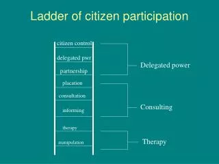
Interactivity of PP GIS applications • Interactivity refers to the user’s interaction with the technology E-participation ladder
GIS functionalities • Topological overlay • Organization in different layers • Information retrieval • Relation of graphic data to attribute data • Query • Retrieval of data according to specified terms • Data selection • Selection of special objects • Zoom and pan • Enlargement or shrinking of map extents in in applications • Distance measure • Measurement of distances between two locations
Information delivery I-MAP Delaware -http://bassriver.state.nj.us/imap_delbasin/
Online discussion Orange County Interactive Mapping -http://www.ci.orlando.fl.us/public_works/esd/gis/interactive_mapping.htm
Map-based discussion Landscape Plan Königslutter am Elm – http://thuja.land.uni-hannover.de/entera/mapserv.phtml
Conclusions • Only few operational applications exist • Lots of theoretical literature on the topic PP GIS • Rising question: Why are just a few PP GIS applications implemented? • Applications vary strongly concerning GIS functionalities and complexity • Further development should be based on the principles of intelligent user interfaces and decision making support systems
Outlook • Development of a prototype PP GIS application in cooperation with the city of Salzburg • Concept definition phase • Definition of user requirements – UML formal method • Usability aspects, usability tests • Analysis of novel visualisation techniques • Test the Prototype application • Focus on sociological issues
Contact: Thank you for your attention! Mag. Renate Steinmann Salzburg Research FG Jakob-Haringer Straße 5/III A - 5020 Salzburg renate.steinmann@salzburgresearch.at +43 (0) 662 2288 281 http://www.salzburgresearch.at/