Download
1 / 1

E N D
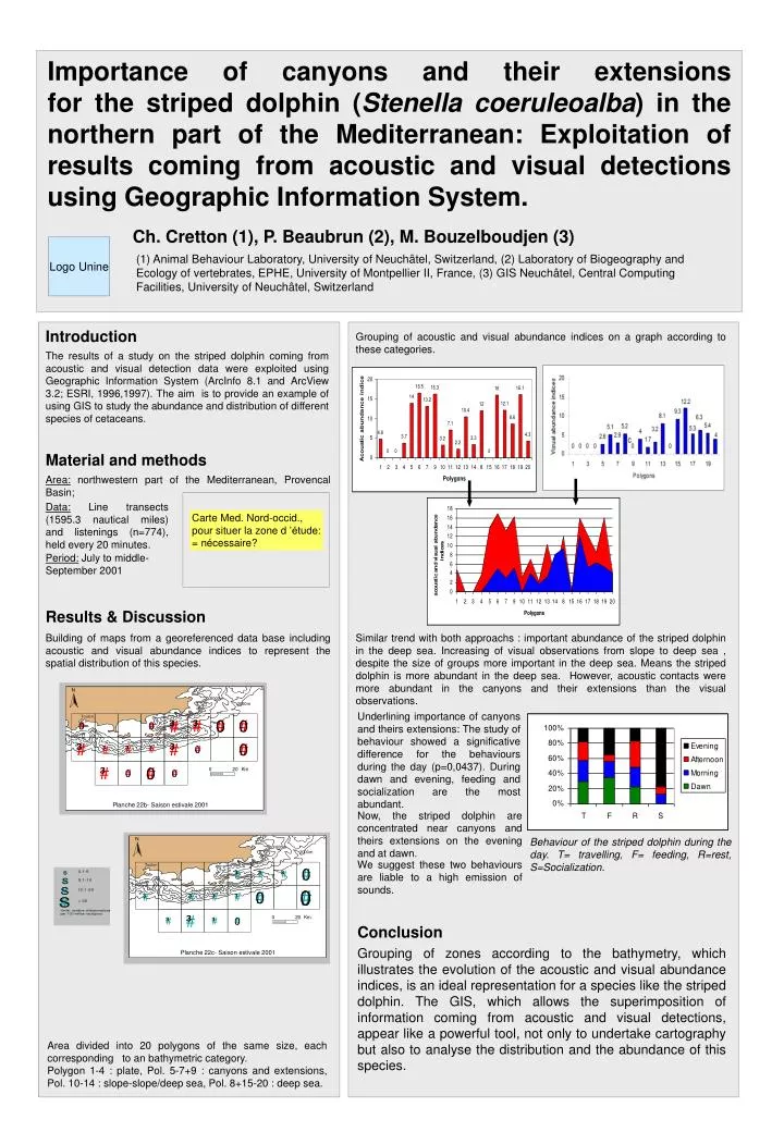
Importance of canyons and their extensions for the striped dolphin (Stenella coeruleoalba) in the northern part of the Mediterranean: Exploitation of results coming from acoustic and visual detections using Geographic Information System. Ch. Cretton (1), P. Beaubrun (2), M. Bouzelboudjen (3) Logo Unine (1) Animal Behaviour Laboratory, University of Neuchâtel, Switzerland, (2) Laboratory of Biogeography and Ecology of vertebrates, EPHE, University of Montpellier II, France, (3) GIS Neuchâtel, Central Computing Facilities, University of Neuchâtel, Switzerland Introduction Grouping of acoustic and visual abundance indices on a graph according to these categories. The results of a study on the striped dolphin coming from acoustic and visual detection data were exploited using Geographic Information System (ArcInfo 8.1 and ArcView 3.2; ESRI, 1996,1997). The aim is to provide an example of using GIS to study the abundance and distribution of different species of cetaceans. Material and methods Area: northwestern part of the Mediterranean, Provencal Basin; Data: Line transects (1595.3 nautical miles) and listenings (n=774), held every 20 minutes. Carte Med. Nord-occid., pour situer la zone d ’étude: = nécessaire? Period: July to middle-September 2001 Results & Discussion Building of maps from a georeferenced data base including acoustic and visual abundance indices to represent the spatial distribution of this species. • Similar trend with both approachs : important abundance of the striped dolphin in the deep sea. Increasing of visual observations from slope to deep sea , despite the size of groups more important in the deep sea. Means the striped dolphin is more abundant in the deep sea. However, acoustic contacts were more abundant in the canyons and their extensions than the visual observations. Underlining importance of canyons and theirs extensions: The study of behaviour showed a significative difference for the behaviours during the day (p=0,0437). During dawn and evening, feeding and socialization are the most abundant. Now, the striped dolphin are concentrated near canyons and theirs extensions on the evening and at dawn. Behaviour of the striped dolphin during the day. T= travelling, F= feeding, R=rest, S=Socialization. We suggest these two behaviours are liable to a high emission of sounds. Conclusion Grouping of zones according to the bathymetry, which illustrates the evolution of the acoustic and visual abundance indices, is an ideal representation for a species like the striped dolphin. The GIS, which allows the superimposition of information coming from acoustic and visual detections, appear like a powerful tool, not only to undertake cartography but also to analyse the distribution and the abundance of this species. Area divided into 20 polygons of the same size, each corresponding to an bathymetric category. Polygon 1-4 : plate, Pol. 5-7+9 : canyons and extensions, Pol. 10-14 : slope-slope/deep sea, Pol. 8+15-20 : deep sea.