Download
1 / 1
10 likes | 135 Views
The Manual Cloud Filtering of GOES-satellite data through combined use of satellite and ground measurements. Purpose of the Study

E N D
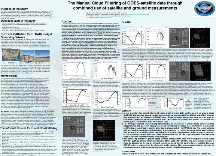
The Manual Cloud Filtering of GOES-satellite data through combined use of satellite and ground measurements • Purpose of the Study • This study is intended to develop an accurate cloud filtering procedure for evaluating the Infrared split window channelsbased Land Surface Temperature (LST) retrievals from Geostationary Satellites over contiguous United States of America. At present the tools developed in the study are manually employed to accomplish accurate cloud filtering. The eventual goal is to develop an automated threshold based cloud filtering scheme for land surface parameter retrievals using space based IR radiometer data. • Data sets used in the study • Ground based Surface Radiation Network (SURFRAD) data of solar irradiance. • Ground based SURFRAD downwelling broadband (3 to 50 microns) thermal sky irradiance. • Ground based SURFAD LST. • GOES Ch4, Ch5, & Ch2 Brightness Temperature data. • GOES Ch1 (visible channel centered around 0.65 microns) reflectance data. M.K. Rama Varma Raja2, Yunyue Yu1, Dan Tarpley1, Hui Xu2, K. Y. Vinnikov3 1NOAA/NESDIS Center for Satellite Applications and Research, email: yunyue.yu@noaa.gov, dan.tarpley@noaa.gov 2 I. M. Systems,Group, Inc. email: rama.mundakkara@noaa.gov, hui.xu@noaa.gov 3 K. Y. Vinnikov, email: kostya@atmos.umd.edu Abstract The Advanced Baseline Imager (ABI) instrument onboard the GOES-R series satellites, which is expected to be launched in the year 2014, has considerable potential for providing accurate retrievals of Land Surface Temperature (LST). At NOAA/NESDIS/STAR, Yu et al. (2008) have developed and refined a number of independent unique split window LST retrieval algorithms applicable for the ABI sensor. These algorithms are being evaluated through radiative transfer model simulations as well as through ground-truth data. For the ground-truth evaluation, the LST algorithms have been applied to one year of GOES-8 and GOES-10 measurements in the year 2001, and then compared with coincident LST estimates from Surface Radiation Network (SURFRAD) irradiance measurements. This paper describes a manual cloud filtering method which we developed for the SUFRAD-GOES data comparison purpose. The manual cloud filtering technique is applied to the spatially closest GOES pixel to the SURFRAD site, to determine if the pixel is cloudy or clear, in order to filter out the cloud-contaminated LST retrievals. This way of pixel cloud filtering employs visual determination of cloudiness based on visible channel 1 reflectance image, IR channel 4 brightness temperature image, daily time series curves of solar irradiance provided by the SURFRAD pyranometer, the broadband sky irradiance provided by the SURFRAD PIR instrument and a number of channel differences. While the solar irradiance curve provides much help during the day time, the down-welling sky irradiance curve is shown to be the most useful tool along with the channel 4 brightness temperature images in cloudiness determination irrespective of whether it is day or night. The combined use of GOES data in five different channels and the paired SURFRAD data of solar irradiance and down-welling sky radiance ensured high quality cloud filtered data during both day and night timings. The details of the manual cloud filtering criteria are discussed. The challenges in effective cloud filtering of GOES-data and how the combined use of GOES and SURFRAD data can be successfully utilized to address them in the context of this study are demonstrated with examples. A future generalized automated cloud detection scheme for satellite based multi-band passive radiometer data is discussed. Results: (a) (b) (d) (c) SURFace RADiation (SURFRAD) Budget Observing Network Figure1 given below shows the location of the SURFRAD sites across United States. The latest addition is at Sioux Falls (SD) in 2003. At each of the observational sites in the network a variety of ground based instruments are routinely providing various radiance measurements. In addition to the radiance measuring instruments there are co-located meteorological instruments for providing surface meteorological observations to complement the radiance data. Also there are cloud tracking cameras to provide information on the sky conditions. Figure. 5 (a,b,c,&d): The time series curve for SURFRAD down-welling infra-red irradiance, time series of SURFRAD solar irradiance, GOES East Channel 4 brightness Temperature image for the hour 21:15 GMT, GOES channel 1 reflectance for the same hour, respectively on September 29, 2001 for Goodwin Creek site. The time series curves show consistently the cloudiness on this day between the period of nearly 17 GMT to 22 GMT. However, the derived parameters from GOES channels such as standard deviation of brightness temperature, various channel differences, (GOES-SURFRAD) LST differences, etc. do not show clearly the presence of cloudiness at the site during this period. The channel 1 reflectance value is low and looks normal, but the pattern is cloudy. If one relies exclusively on satellite channel derived parameters to detect cloudiness in this case, possibly this could be erroneously classified as clear. However the use of ground based SURFRAD data helped to correctly detect the presence of cloudiness over the site. This example demonstrates the value of ground based data sets from routine observational network such as SURFRAD, CRN, GEWEX, etc. in efficient cloud filtering of satellite IR data for Land Surface applications. (b) (d) (a) (c) Figure 1. SURFRAD sites Figure 2a. SURFRAD suite Figure 2b. PIR tower The temporal resolution of the SURFRAD data is 3-minutes. The SURFRAD down-looking Precision Infrared Radiometer (PIR) measures the up-welling radiation in the spectral range from 3 microns to 50 microns (Augustine et al., 2000; 2005). LST is estimated from this up-welling irradiance measurements. Similarly the up-looking PIR measures the down-welling sky irradiance in the same spectral range. The photograph of PIRs from Pennsylvania State University site is shown in Figures 2 a & b. Methodology The spatially closest GOES pixel is chosen for cloud filtering. The spatially closest pixel is identified as the one with minimum resultant distance to SURFRAD site. Once the closest pixel is identified the corresponding GOES imager brightness temperature data from Channel 2 (Ch2), Channel 3 (Ch3), Channel 4 (Ch4), and Channel 5 (Ch5) are used to form the channel differences such as Ch4-Ch5, Ch4-Ch2 and Ch4-Ch3. In addition to the channel differences, the standard deviation of Ch4 brightness temperature for a 3 by 3 array with the spatially closest pixel as the center is computed. These estimated GOES channel differences and standard deviation are used in conjunction with ground based SURFRAD data to determine if the spatially closest pixel is cloudy or clear. The SURFRAD data sets used are the daily time series of down-welling solar irradiance measured by the up-looking SURFRAD pyranometer and down-welling broad-band sky irradiance measured by the up-looking Precision Infrared Radiometer with a band width from 3 microns to 50 microns. In addition to these, the daily LST values derived from the upwelling irradiance measured at the SURFRAD sites are also used in the determination of cloudy versus clear conditions. The temporally closest SURFRAD observation to the GOES observation time is picked-up for forming the coincident GOES-SURFRAD pair. The SURFRAD land surface temperature used in the cloud filtering corresponds to this temporally closest observation. For day time clear sky conditions the corresponding time series curve of SURFRAD down-welling solar irradiance should appear as a smooth parabolic curve without any distortion (see Figure 3a). If there is any distortion, then it is generally an indication of presence of cloudiness for the corresponding times (see Figure 3b). Figure. 3a. The time series of the solar irradiance on February 3, 2001, measured by the SURFRAD pyranometer at Goodwin Creek Site. Note that the solar irradiance varies smoothly as a function of time. This is typical behavior of solar irradiance on a clear day. Figure. 3b. The time series of the solar irradiance on February 4, 2001, measured by the SURFRAD pyranometer at Goodwin Creek Site. The solar irradiance curve is highly distorted in this case indicating the presence of cloudiness over the site. Figure. 6 (a,b,c,&d): The time series curve for SURFRAD down-welling infra-red irradiance, time series of SURFRAD solar irradiance, GOES East Channel 4 brightness Temperature image for the hour 17:02 GMT, GOES channel 1 reflectance for the same hour, respectively on April 29, 2001 for Bondville site. The time series curves show consistently the clear-sky condition most of the hours on this day. Accordingly the derived standard deviation of GOES channel 4 brightness temperature is significantly smaller. However (GOES-SURFRAD) LST differences are relatively larger for a number of GOES-hourly retrievals on this day including 17:02 GMT making it a suspicious retrieval with cloud contamination. The surface temperature estimate from SURFRAD and top-of-the atmosphere brightness temperature has larger difference (usually for most of the clear conditions it is 5K or less) which reduces further the confidence in retrieval. However the SURFRAD time series curves shown here confirm that the observations are made under clear-conditions as solar irradiance curve and down-welling irradiance curve do not show any impact of cloudiness. Thus the reason for observed large difference in LST is not related to cloud contamination, but related to the representativeness of the SURFRAD LST for its surroundings. This example demonstrates the value of ground based data sets from routine observational network such as SURFRAD, CRN, GEWEX, etc. in avoiding false detection of cloudiness and ensure efficient cloud detection of satellite IR data for Land Surface applications. Figure 7a. Figure 7 (a & b): Time series curves of SURFRAD solar irradiance and sky irradiance on May 9, 2001, for Desert Rock site. Comparison of these two curves demonstrates the usefulness of sky irradiance measurements in detecting thin sub-visible clouds. Broadband sky irradiance shows kinks usually indication of cloudiness Solar irradiance does not show any cloud effect Figure 4a: Typical time series curve of down-welling sky irradiance in the 3 microns to 50 microns band on a clear day (October 18, 2001) at Goodwin Creek (black curve). Note that the sky irradiance pattern is relatively smooth varying in this case. Corresponding sky temperature time series also is shown (red curve). Figure 7b. Figure 4b: Time series curve of down-welling sky irradiance (black) in the 3 microns to 50 microns band on February 3, 2001, at Goodwin Creek. Note that the sky irradiance pattern shows enhancing kinks at different times of the day, which is generally an indication of the presence of cloudiness over the site.. The time series curve of solar irradiance is useful in determining cloudy or clear sky conditions during day time only. The time series of down-welling sky irradiance in the 3 microns to 50 microns band can be effectively used to determine the clear or cloudy conditions, irrespective of day or night. Ideally under clear sky conditions the daily down-welling infrared sky irradiance should appear as a smoothly varying curve as a function of time without any significant distortions or kinks (see Figure 4a). For most of the cloudy conditions, the sky irradiance measured at the SURFRAD site appeared to have enhancing kinks because of the fact that cloud is warmer than the sky radiation presumably coming from space or upper atmosphere (see Figure 4b). The distortions in the daily time series curves of down-welling solar irradiance and down-welling sky irradiance corresponding to the hour of GOES observation under analysis are visually diagnosed and used to determine if the spatially closest GOES pixel is cloudy or cloud less. Figures 4 (c and d) are hourly GOES Channel 4 and Channel 1 images respectively showing a clear case on October 18, 2001 at Goodwin Creek site. • SUMMARY • A new procedure for manual filtering of clouds which employs both satellite as well as ground-based SURFRAD data sets has been developed and applied over one year (2001) of GOES-8 and GOES10 imager data matched with six different SURFRAD sites. These manually filtered data sets are then used to evaluate LST algorithm performance (see Yu et al. 2008, Poster P1.9) and also for studies on seasonal and diurnal cycles (see Vinnikov et al. 2008, Poster 1.56). • The developed manual cloud filtering demonstrates the usefulness of ground-based solar irradiance measurements and the down-welling broadband sky thermal irradiance measurements in identification and filtering of cloudiness in satellite pixel data in close proximity to SURFRAD site. The solar irradiance data are found to be mainly useful during day time in detection of clouds. But down-welling sky irradiance data are found to be useful for both day and night. In addition down-welling irradiance helps in detection of thin sub-visible clouds. Also it has been demonstrated that the use of ground-based SURFRAD data helps in potential false identification of cloudy pixels. • With increasing number of ground-based radiation measurement sites over Contiguous United States (CONUS) such as Climate Reference Network (CRN), SURFRAD, GEWEX, and other similar network, it might be possible to develop an efficient operational cloud filtering scheme for any satellite data over CONUS region or regions over the globe with similar network. Thus ground-based radiation data can be complementary to multi-band satellite radiometer data for cloud filtering purpose. • FUTURE WORK • To consolidate the manual cloud filtering tool into an automated cloud filtering algorithm for satellite data. The Informal Criteria for visual cloud filtering • The difference between the top of the atmosphere channel 4 brightness temperature from GOES satellite for the spatially closest pixel and the land surface temperature derived from SURFRAD measurements should be generally 5 K or less for clear sky conditions. • The standard deviation of the 3 by 3 pixel array GOES channel 4 brightness temperature should no exceed 1.5 K. • The absolute difference between GOES channel 4 and channel 2 brightness temperatures should not exceed 5 K. • The absolute difference between GOES channel 4 and channel 5 brightness temperatures should not exceed 1 K. • The time series curves of solar irradiance should be smoothly varying without distortions. • The time series curves of down-welling infrared irradiance also should be smoothly varying in time without any significant enhancement. • The average reflectance for the spatially closest GOES-pixel should be generally less than 40% except for snow conditions which can be mostly identified from sequence of hourly GOES images. Snow is more static than clouds. • Finally the 0.5 degree by 0.5 degree around the SURFRAD site must be visually clear of clouds to form coincident pairs of cloud-free SURFRAD and GOES data. Figure 4c: Image of GOES Channel 4 BT, corresponding to16:02 GMT on October 18, 2001 at Goodwin Creek. The orange cross mark at the center shows the SURFRAD site. The parameters on the image correspond to spatially closest GOES pixel and are: Ts (SURFRAD LST), Tb4 (GOES Ch4 BT),Dif (Ts-Tb4), SD (stdev of Tb4), GST (GOES retrieved LST), Df (Ts-GST), Dis(resultant distance in km), T5 (Channel 5 BT), Df (Tb4-T5), AT (atmospheric temperature), Df (Ts-AT), Df (GST-Tb4), C42 (Tb4-Channel 2 BT), C43 (Tb4-Channel 3 BT). Figure 4d: Image of GOES Channel 1 reflectance Corresponding to 16:02 GMT on October 18, 2001 at Goodwin Creek. The parameter ‘R’ printed is the reflectance which corresponds to the spatially closest pixel to SURFRAD site. This case represents a clear-pixel case.