Download
1 / 39
410 likes | 555 Views
Lunch-time seminar 2007. Synergy of radar, lidar and radiometer for observing ice clouds. Julien Delanoë & Robin Hogan University of Reading, UK. Outline. Lunch-time seminar 2007. Why are clouds interesting ? Means for observing ice clouds

E N D
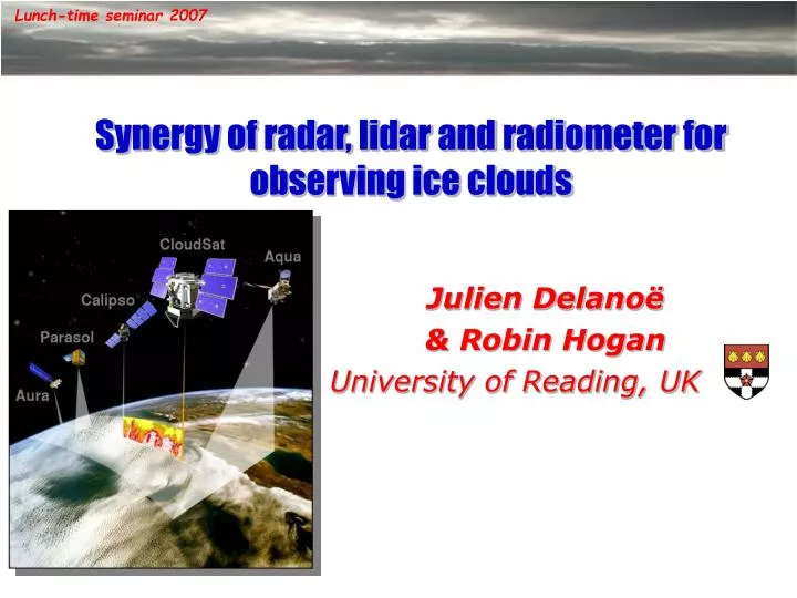
Lunch-time seminar 2007 Synergy of radar, lidar and radiometer for observing ice clouds Julien Delanoë & Robin Hogan University of Reading, UK .
Outline Lunch-time seminar 2007 • Why are clouds interesting ? • Means for observing ice clouds • Synergy radar, lidar, radiometers and variational method • Ground based example • Retrievals from space
Motivation Clouds and feedback Feedback (W.m-2.K-1) (Bony et al. 2006) Clouds All Lunch-time seminar 2007 • Clouds and global warming : Large uncertainties: climate models predict 2 to 6°C in average over the next 100 years (IPCC 2001): clouds are a part of these uncertainties • Clouds strongly influence the earth’s radiative budget: Opposing effects on climate : warming (green-house effect) / cooling (albedo) Ice clouds : what is the sign of the net radiative forcing ? Depends on the clouds properties and how clouds are distributed =>Improve clouds representation in models (cloud fraction/ clouds properties) We have to improve our knowledge on clouds to better characterize the cloud feedback.
Means for studying clouds What are the means available for studying clouds ? Lunch-time seminar 2007
Means for studying clouds Lunch-time seminar 2007 Which means for studying clouds ? 1. Eyes ! Not that easy to evaluate the Ice Water Content !
Means for studying clouds OAP-2D2 Lunch-time seminar 2007 2. Airborne in-situ measurements Captors are located on a air craft, sample the cloud… • Dimensional distribution of ice particles, concentration of ice particles as a function of their size. • Shape of the particle • Ice water content Examples of captor : • Main advantage, access to the fine description of the particle distribution. • However the in situ aircraft measurements, although very useful, are too spatially restricted
Means for studying clouds Lunch-time seminar 2007 3. Remote sensing, 2 approaches : Active and passive • Active : cloud radar, cloud lidar Cloud radar 35GHz or 94GHz Electromagnetic waves are emitted by the radar, a part is back-scattered by cloud particles and collected by the radar dish Measurements : reflectivity (Z in dBZ), and if Doppler available Doppler velocity (Vd in m.s-1) It is very sensitive to the size of the particles
Means for studying clouds Lunch-time seminar 2007 Cloud lidar 532nm or 1064nm Electromagnetic waves (laser) are emitted by the lidar, a part is back-scattered by cloud particles and collected by the lidar telescope Measurements : attenuated backscatter (b in m-1 sr-1), and if Doppler available Doppler velocity (Vd in m.s-1) It is very sensitive to the concentration of the particles Multiple scattering can be large if the telescope field of view is wide
Means for studying clouds Particles become too big and the lidar is strongly attenuated Reflectivity radar [dBZ] Radar and lidar, both can detect the cloud => synergy Particles very small only lidar Attenuated backscatter lidar [m-1 sr-1] http://www.cem.msu.edu/~reusch/VirtualText/Spectrpy/UV-Vis/spectrum.htm Cloud Lidars Cloud radars Ground-base radar/lidar 1st April 2003 Palaiseau France (Frontal ice cloud) Lunch-time seminar 2007 But why radar and lidar together ? Radar sensitive to big particles & Lidar sensitive to the particle concentration
Means for studying clouds Wavelength depends on the application : (example MODIS, for clouds) Visible IR Lunch-time seminar 2007 b. Passive remote sensor : radiometers radiometer : device used to measure the radiant flux or power in electromagnetic radiation without emission from the instrument. The measurement is integrated in the opposite of radar and lidar. It is very useful for radiativestudy of our atmosphere. The clouds on February 14, 2007, parted above the United Kingdom Bands Used: 1, 4, 3 Credit: Jeff SchmaltzMODIS Land Rapid Response Team,NASA GSFC MODIS, Calipso and SEVIRI each have 3 thermalinfrared channels in atmospheric window region Radiance depends on vertical distribution of microphysical properties Single channel: information on extinction near cloud top Pair of channels: ice particle size information near cloud top
Which platform for radar, lidar radiometers and what for ?Ground based, airborne, satellites ? Lunch-time seminar 2007
Means for studying clouds CloudNet data 09/09/06 Chilbolton Lunch-time seminar 2007 1. Ground based ARM CloudNET Radar, lidar, radiometers + … continuous observation -CloudNET: Europe, 3 sites at the beginning: Cabauw / Chilbolton / Palaiseau -ARM(Atmospheric Radiation Measurement): World wide, several sites Ideally designed for local climatology and statistical validations of climate/forecast models and satellites.
Means for studying clouds Example of measurements Lidar Leandre (532 nm) Radar Rasta (94GHz) Precipitation Lunch-time seminar 2007 2. Airborne Radar-Lidar Example RALI (RAdar LIdar) Intensive observations periods Ideally designed for detailed study case of clouds processes. Demonstrator spatial, it can be use to validate Satellite measurement (flying under the trace of the Satellite, CloudSat/CALIPSO during AMMA sept 2006)
Means for studying clouds Lunch-time seminar 2007 3. Satellites ! A-Train CloudSat: Cloud profiler radar 94GHz CALIPSO: Cloud profiler lidar 532, 1064nm + Infra Red Imager AQUA: radiometers MODIS, AIRS, CERES, AMSR-E http://www-calipso.larc.nasa.gov/about/constellation.html The CloudSat radar and the Calipso lidar were launched on 28th April 2006 They join Aqua, hosting the MODIS, CERES, AIRS and AMSU radiometers An opportunity to tackle questions concerning role of clouds in climate Need to combine all these observations to get an optimum estimate of global cloud properties
Technical part: Radar, lidar, radiometers method Lunch-time seminar 2007
What for? Lunch-time seminar 2007 An algorithm to combine radar, lidar, radiometers • Introduction • Why combine radar, lidar and radiometers? • Radar ZD6, lidar b’D2 so the combination provides particle size • Radiances ensure that the retrieved profiles can be used for radiative transfer studies • Single channel: information on extinction near cloud top • Pair of channels: ice particle size information near cloud top • Some limitations of existing radar/lidar ice retrieval schemes (Donovan et al. 2000, Tinel et al. 2005, Mitrescu et al. 2005) • Only work in regions of cloud detected by both radar and lidar • Noise in measurements results in noise in the retrieved variables • The common multiple scattering model is too slow (Eloranta’s code) • Other clouds in the profile are not included, e.g. liquid water clouds • Difficult to make use of other measurements, e.g. passive radiances • A “unified” variational scheme can solve all of these problems
Variational approach Forward Model: Convert first guess in observations Predicted observations Compare predicted observations and measurements, with an a-priori and measurement errors as a constraint Clever mathematics Iterative process Lunch-time seminar 2007 Variational scheme : brief description We know the observations (instrument’s measurements) and we would like to know cloud properties : visible extinction, Ice water content, effective radius… Observations: whatever you want observation vector y First guess of clouds parameters, state vector x Direct Model, you don’t have to inverse the measurements
Ice visible extinction coefficient profile Attenuated lidar backscatter profile Ice normalized number conc. profile Radar reflectivity factor profile (on different grid) Extinction/backscatter ratio for ice Liquid water path and number conc. for each liquid layer Visible optical depth Infrared radiance Radiance difference Aerosol visible extinction coefficient profile Lunch-time seminar 2007 Formulation of variational scheme 2. Formulation • Observation vector • State vector • Elements may be missing
Forward model a Z Lunch-time seminar 2007 3. Forward model We need a model to simulate observations from state vector To do that we use lookup tables and radar, lidar, radiative forward models. What kind of Lookup tables? for example we need a relationship between a and Z Unfortunately : this relationship is really scattered … So what can we do ?
Forward model N(D) Lunch-time seminar 2007 The dimensional particle size distribution N(D) :PSD To simulate instrument measurements we need to know the particle concentration by unit of volume. If we know how are distributed ice particles in a sample volume, from the characteristic of one particle you can compute the characteristic of a volume => We can estimate the radar reflectivity for example : Radar Reflectivity [mm6.m-3] sbsc(D)backscatter coefficient (Mie,1908) Visible extinction [m-1] A(D) cross-section projected area N(D) is a key parameter !
N(D)=N0* F(D/D*) N0*: intercept parameter if exponential shape Z=f(a,N0*) N(D) N(D)/N0* a/N0* a Z D/D* Z/N0* Lunch-time seminar 2007 Dimensional particle size distribution N(D) Very variable ! Different for each cloud • We use the normalization concept of particle size distribution (Delanoë et al./Field et al. 2005): N(D)=N0*F(D/D*) where N0* is the normalization parameter and F the intrinsic shape (can be represented by a mathematical function) N(D) Scaled in Size by D* and in concentration by N0* Same for deriving re, IWC etc …
Radar forward model and a priori Example of relationship between N0*, a and T => Lunch-time seminar 2007 • A priori and first guess • First guess of a : constant value • N0* is computed from an a priori relationship between N0*, a and the temperature (derived from in situ measurements) • Radar forward model and lookup tables • We fix the mass-area-diameter relationships • Mie theory (95-GHz) for computing backscatter coefficient • The forward model predict Z from the extinction and N0* via : Z=f(a/N0*) • Effective radius via re=f(a/N0*) • Ice water content : IWC =f(a/N0*)
Lidar forward model Narrow field-of-view: forward scattered photons escape Wide field-of-view: forward scattered photons may be returned Lunch-time seminar 2007 • Lidar Multiple scattering Degree of multiple scattering increases with field-of-view angle New method (Hogan 2006) faster than Eloranta’s code usually used Attenuated backscatter profile : • From a profile and S (ratio a/b) and the Multiple scattering model (Hogan 2006) ba=f(a, Multiple Scattering contribution, S) With be=(1/S)a and Increases the backscatter signal
radiance forward model Lunch-time seminar 2007 • Radiances Radiance model uses the 2-stream source function method (Toon et al. (1989)) • Efficient yet sufficiently accurate method that includes scattering • Ice single-scatter properties from Anthony Baran’s aggregate model • Correlated-k-distribution for gaseous absorption (from David Donovan and Seiji Kato) • Radiative properties, asymetry factor, single-scatter albedo etc … as a function of a/NO* from lookup tables
applicability Lunch-time seminar 2007 Summary
Applications, examples of retrievals- ground based- Satellite Lunch-time seminar 2007
Ground based application Lunch-time seminar 2007
Ground based applications Lunch-time seminar 2007 This kind of method is applied to ground based measurements, where radiometric measurements come from Meteo-Sat Second Generation, severi radiometer Campaign AMMA : ARM « Mobile Facility » Niamey Altitude:223 m Latitude:13.47 degree north Longitude:2.17 degree east Sample case : 22nd July 2006 • radar • lidar • Radiometer (msg), IR 8.7, 10.8, 12µm
Example from the AMF in Niamey Lunch-time seminar 2007 Observed Radar Reflectivity 95-GHz Attenuated lidar backscatter return 523-nm Radar reflectivity Forward model Attenuated lidar backscatter Forward model Z radar b lidar
Results Radar+lidar only Large error where only one instrument detects the cloud Lunch-time seminar 2007 Retrievals in regions where radar or lidar detects the cloud Retrieved visible extinction coefficient Retrieved effective radius Retrieval error in ln(extinction)
Results Radar, lidar, SEVERI radiances Cloud-top error is greatly reduced Retrieval error in ln(extinction) Lunch-time seminar 2007 TOA radiances increase the optical depth and decrease particle size near cloud top Retrieved visible extinction coefficient Retrieved effective radius
Lunch-time seminar 2007 Satellite application : A-TRAINCloudSat-CALIPSO-AQUA
Examples of measurements [1] Precipitation: Lidar too attenuated No signal from the lidar Cloudtop: Radar not sensitive enough to “see” the cloudtop Molecular signal 2006172010247_00782_1h13_1h24 Radar Reflectivity from CloudSat Attenuated lidar backscatter from CALIPSO
Examples of measurements [2] Super cooled water: Strong signal from lidar, weak (or nothing) from radar 2006286023036_02443_2h46_2h57 Radar Reflectivity from CloudSat Attenuated lidar backscatter from CALIPSO
Retrieval from space ! Lunch-time seminar 2007 Oct 13th 2006 between 3h52 and 3h58 UTC AVHRR Radar Reflectivity from CloudSat Height [km] 3h52 3h55 3h58 Attenuated lidar backscatter from CALIPSO Height [km]
Forward model Molecular signal Lunch-time seminar 2007 Observed Radar Reflectivity 95-GHz Attenuated lidar backscatter return 523-nm Radar reflectivity Forward model Attenuated lidar backscatter Forward model
Preliminary results Retrieved visible extinction coefficient Height [km] Retrieved effective radius Height [km] Retrieved concentration number Height [km] Retrieved error in ln(extinction) Height [km] Lunch-time seminar 2007 RADAR+LIDAR October 13th 2006 Granule 2006286023036_02443 between 3h52 and 3h58 UTC Error very small in the common area
Supercooled water layers Lunch-time seminar 2007 Preliminary results Retrieved radiances vs MODIS radiances Radiances not used as constraints, only to check the validity of the retrieved profile, it will be implemented very soon Cloud optically thin, simulated radiances noisy Radar Reflectivity from CloudSat Height [km] Attenuated lidar backscatter from CALIPSO Height [km] Radiances W sr-1 m-2 Forward model MODIS 8.4 – 8.7 micron 10.78 – 11.25 micron 11.77 – 12.27 micron
Conclusions and ongoing work Lunch-time seminar 2007 • Conclusion • New variational scheme, combining radar, lidar, radiometer and/or any other relevant measurement in order to retrieve cloud properties profiles • Can be applied to ground based or satellite data • Ongoing work: • Retrieve properties of liquid-water layers, drizzle and aerosol • Make it easy to use radiances as a constraint (satellite data), supercooled water etc … • Incorporate microwave radiances for deep precipitating clouds • Apply to A-train data and validate using in-situ underflights • Develop cloud climatology and use to evaluate forecast/climate models • Quantify radiative errors in representation of different sorts of cloud