Download
1 / 46
1.29k likes | 2.82k Views
EARTHQUAKE. Sarada Mandal Associate Professor in Geography Teacher-in-Charge PRABHU JAGATBANDHU COLLEGE Andul , Howrah. EARTHQUAKE. Definition of Earthquake.

E N D
EARTHQUAKE SaradaMandal Associate Professor in Geography Teacher-in-Charge PRABHU JAGATBANDHU COLLEGE Andul, Howrah
Definition of Earthquake • An earthquake is the sudden, sometimes violent movement of the earth's surface from the release of energy in the earth's crust. Earthquakes occur when energy stored within the Earth, usually in the form of strain in rocks, suddenly releases. This energy is transmitted to the surface of the Earth by earthquake waves. The study of earthquakes and the waves they create is called seismology (from the Greek seismos, “to shake”). Scientists who study earthquakes are called seismologists.
FOCUS AND EPICENTRE • The point within the Earth along the rupturing geological fault where an earthquake originates is called the focus, or hypocenter. • The point on the Earth’s surface directly above the focus is called the epicenter. • Earthquake waves begin to radiate out from the focus and subsequently form along the fault rupture. If the focus is near the surface—between 0 and 70 km (0 and 40 mi) deep—shallow-focus earthquakes are produced. • If it is intermediate or deep below the crust—between 70 and 700 km (40 and 400 mi) deep—a deep-focus earthquake will be produced. • Shallow-focus earthquakes tend to be larger, and therefore more damaging, earthquakes. This is because they are closer to the surface where the rocks are stronger and build up more strain.
Earthquake waves • There are four kinds of wave produced by an earthquake. Two move over the surface, causing damage, and two pass through the Earth itself: body waves. • By studying body waves, scientists have worked out what the Earth is like inside: • Body waves tell us a great deal about what we cannot see inside the planet. • - P-waves: Primary waves are longitudinal waves that push and pull the earth. They are the fastest body wave, averaging speeds of about 6 km/s and so arrive first. • - S-waves: Secondary waves are transverse waves, which make the earth shake from side to side. Slower than P waves, they average about 4 km/s and so arrive second. • Both S and P waves travel throughout the body of the earth, and can be picked up by seismometers - machines that record earthquakes - anywhere in the world. • However, it turns out that S waves cannot travel through the core, and only P waves are recorded in some places:
Causes of Earthquake • Plate tectonics • Elastic Rebound theory – Propounded by Harry Fielding Reid in 1911 • Occurrence of Fault • Volcanism • Actions of Man
PLATE TECTONICS • Most Earthquakes are caused by Plate Tectonics. The earth's crust consists of a number of sections or plates that float on the molten rock of the mantle. These plates move on convection currents caused by heat rising from the center of the earth. The hot magma rises and spreads out on the surface, creating new crust. The crust spreads out forming a new plate until it meets another plate. One of the plates will be pushed down into the interior of the earth and reabsorbed into the mantle. Plates can also be compressed to push up mountains when they collide or move sideways along transform faults.
FAULTS • Most earthquakes are caused by the sudden slip along geologic faults. The faults slip because of movement of the Earth’s tectonic plates. This concept is called the elastic rebound theory. The rocky tectonic plates move very slowly, floating on top of a weaker rocky layer. As the plates collide with each other or slide past each other, pressure builds up within the rocky crust. Earthquakes occur when pressure within the crust increases slowly over hundreds of years and finally exceeds the strength of the rocks. Earthquakes also occur when human activities, such as the filling of reservoirs, increase stress in the Earth’s crust.
Elastic Rebound Theory • In 1911 American seismologist Harry Fielding Reid studied the effects of the April 1906 California earthquake. He proposed the elastic rebound theory to explain the generation of certain earthquakes that scientists now know occur in tectonic areas, usually near plate boundaries. This theory states that during an earthquake, the rocks under strain suddenly break, creating a fracture along a fault. When a fault slips, movement in the crustal rock causes vibrations. The slip changes the local strain out into the surrounding rock. The change in strain leads to aftershocks (smaller earthquakes that occur after the initial earthquake), which are produced by further slips of the main fault or adjacent faults in the strained region. The slip begins at the focus and travels along the plane of the fault, radiating waves out along the rupture surface. On each side of the fault, the rock shifts in opposite directions. The fault rupture travels in irregular steps along the fault; these sudden stops and starts of the moving rupture give rise to the vibrations that propagate as seismic waves. After the earthquake, strain begins to build again until it is greater than the forces holding the rocks together, then the fault snaps again and causes another earthquake.
Human Activities • Fault rupture is not the only cause of earthquakes; human activities can also be the direct or indirect cause of significant earthquakes. Injecting fluid into deep wells for waste disposal, filling reservoirs with water, and firing underground nuclear test blasts can, in limited circumstances, lead to earthquakes. These activities increase the strain within the rock near the location of the activity so that rock slips and slides along pre-existing faults more easily. While earthquakes caused by human activities may be harmful, they can also provide useful information. Prior to the Nuclear Test Ban treaty, scientists were able to analyze the travel and arrival times of P waves from known earthquakes caused by underground nuclear test blasts. Scientists used this information to study earthquake waves and determine the interior structure of the Earth.
Volcanic Earthquakes • Volcanic earthquakes occur near active volcanoes but have the same fault slip mechanism as tectonic earthquakes. Volcanic earthquakes are caused by the upward movement of magma under the volcano, which strains the rock locally and leads to an earthquake. As the fluid magma rises to the surface of the volcano, it moves and fractures rock masses and causes continuous tremors that can last up to several hours or days. Volcanic earthquakes occur in areas that are associated with volcanic eruptions, such as in the Cascade Mountain Range of the Pacific Northwest, Japan, Iceland, and at isolated hot spots such as Hawaii.
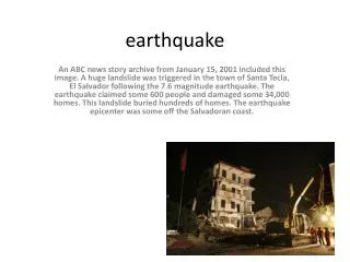
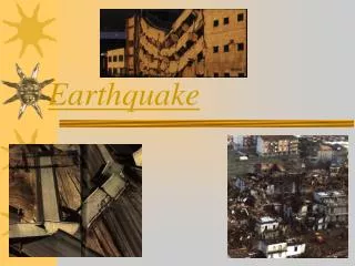
Results of Earthquake • Landslide • Soil liquefaction • Fire • Tsunami waves and flooding • Diseases
Seismograph • A seismometer records the vibrations from earthquakes. Mechanical versions work by way of a large mass, freely suspended. • In the example on the right, a rotating drum records a red line on a sheet of paper. If the earth moves (in this case from left to right) the whole machine will vibrate too. • However, the large mass tends to stay still, so the drum shakes beneath the pen, recording a squiggle. • The confiner prevents the mass from bouncing around all over the place. • Incidentally, a seismograph is the graph that a seismometer draws
Magnitude of Earthquake FIGURE 1 - CHARLES RICHTER STUDYING A SEISMOGRAM
Magnitude of Earthquake • One of Dr. Charles F. Richter's most valuable contributions was to recognize that the seismic waves radiated by all earthquakes can provide good estimates of their magnitudes. . He collected the recordings of seismic waves from a large number of earthquakes, and developed a calibrated system of measuring them for magnitude. • Richter showed that, the larger the intrinsic energy of the earthquake, the larger the amplitude of ground motion at a given distance. He calibrated his scale of magnitudes using measured maximum amplitudes of shear waves on seismometers particularly sensitive to shear waves with periods of about one second. The records had to be obtained from a specific kind of instrument, called a Wood-Anderson seismograph. Although his work was originally calibrated only for these specific seismometers, and only for earthquakes in southern California, seismologists have developed scale factors to extend Richter's magnitude scale to many other types of measurements on all types of seismometers, all over the world. In fact, magnitude estimates have been made for thousands of Moon-quakes and for two quakes on Mars.
Richter Magnitude of Earthquake • The equation for Richter Magnitude is: ML = logA(mm) + (Distance correction factor)Here A is the amplitude, in millimeters, measured directly from the photographic paper record of the Wood-Anderson seismometer, a special type of instrument. The distance factor comes from a table that can be found in Richter's (1958) book Elementary Seismology. In the 'Richter scale'. An increase of one unit represents a thirty-fold increase in energy, so an earthquake like the one that ruined Kobe in Japan in 1995 (magnitude nearly 7) was about 900 times as powerful as the earthquake felt in England and Wales in 1990 (magnitude about 5).
Disadvantage of Richter scale • Over-dependence on instrumental reading • No scope for physiographic and tectonic parameters
Seismic Moment • Seismologists have more recently developed a standard magnitude scale that is completely independent of the type of instrument. It is called the moment magnitude, and it comes from the seismic moment. • To get an idea of the seismic moment, we go back to the elementary physics concept of torque. A torque is a force that changes the angular momentum of a system. It is defined as the force times the distance from the center of rotation. Earthquakes are caused by internal torques, from the interactions of different blocks of the earth on opposite sides of faults. After some rather complicated mathematics, it can be shown that the moment of an earthquake is simply expressed by:
Seismic Moment The formula above, for the moment of an earthquake, is fundamental to seismologists' understanding of how dangerous faults of a certain size can be. Next let's take the energy we found for the Double Spring Flat earthquake and estimate its magnitude:
Seismic Energy Both the magnitude and the seismic moment are related to the amount of energy that is radiated by an earthquake. Richter, working with Dr. Beno Gutenberg, early on developed a relationship between magnitude and energy. Their relationship is: • logES = 11.8 + 1.5M giving the energy ES in ergs from the magnitude M. Note that ES is not the total ``intrinsic'' energy of the earthquake, transferred from sources such as gravitational energy or to sinks such as heat energy. It is only the amount radiated from the earthquake as seismic waves, which ought to be a small fraction of the total energy transfered during the earthquake process. More recently, Dr. Hiroo Kanamori came up with a relationship between seismic moment and seismic wave energy. It gives: Energy = (Moment)/20,000
Earthquake Intensity GIUSEPPE MERCALLI
Evolution of the Mercalli scale The Mercalli scale originated with the widely used simple ten-degree Rossi-Forel scale, which was revised by Italian volcanologist Giuseppe Mercalli in 1883 and 1902. The terms Mercalli intensity scale or Mercalli scale should not be used unless one really means the original ten-degree scale of 1902. In 1902 the ten-degree Mercalli scale was expanded to twelve degrees by Italian physicist Adolfo Cancani. It was later completely re-written by German geophysicist August Heinrich Sieberg and became known as the Mercalli-Cancani-Sieberg (MCS) scale. The Mercalli-Cancani-Sieberg scale was later modified and published in English by Harry O. Wood and Frank Neumann in 1931 as the Mercalli-Wood-Neuman (MWN) scale. It was later improved by Charles Richter, the father of the Richter magnitude scale. The scale is known today as the Modified Mercalli Scale and commonly abbreviated MM.
Modified Mercalli The lower degrees of the MM scale generally deal with the manner in which the earthquake is felt by people. The higher numbers of the scale are based on observed structural damage. The table below is a rough guide to the degrees of the Modified Mercalli Scale. The colors and descriptive names shown here differ from those used on certain shake maps in other articles.
Modified Mercalli • Instrumental Not felt except by a very few under especially favorable conditions • Feeble Felt only by a few persons at rest, especially on upper floors of buildings. Delicately suspended objects may swing. • Slight Felt quite noticeably by persons indoors, especially on the upper floors of buildings. Many do not recognize it as an earthquake. Standing motor cars may rock slightly. Vibration similar to the passing of a truck. Duration estimated.
Modified Mercalli iv. Moderate Felt indoors by many, outdoors by few during the day. At night, some awakened. Dishes, windows, doors disturbed; walls make cracking sound. Sensation like heavy truck striking building. Standing motor cars rocked noticeably. Dishes and windows rattle alarmingly. V. Rather Strong Felt by nearly everyone; many awakened. Some dishes and windows broken. Unstable objects overturned. Clocks may stop. VI. Strong Felt by all; many frightened and run outdoors, walk unsteadily. Windows, dishes, glassware broken; books off shelves; some heavy furniture moved or overturned; a few instances of fallen plaster. Damage slight.
Modified Mercalli VII. Very Strong Difficult to stand; furniture broken; damage negligible in building of good design and construction; slight to moderate in well-built ordinary structures; considerable damage in poorly built or badly designed structures; some chimneys broken. Noticed by persons driving motor cars VIII. Destructive Damage slight in specially designed structures; considerable in ordinary substantial buildings with partial collapse. Damage great in poorly built structures. Fall of chimneys, factory stacks, columns, monuments, walls. Heavy furniture moved. IX. Ruinous General panic; damage considerable in specially designed structures, well designed frame structures thrown out of plumb. Damage great in substantial buildings, with partial collapse. Buildings shifted off foundations
Modified Mercalli X. Disastrous Some well built wooden structures destroyed; most masonry and frame structures destroyed with foundation. Rails bent. XI. Very Disastrous Few, if any masonry structures remain standing. Bridges destroyed. Rails bent greatly. XII. Catastrophic Total damage - Almost everything is destroyed. Lines of sight and level distorted. Objects thrown into the air. The ground moves in waves or ripples. Large amounts of rock may move.
EXAMPLES OF OTHER INTENSITY-SCALE • MSK-64(Medvedev-Sponheur-Karnik scale) • MSK-81 • EMS (European Macro-seismic) Scale
Disadvantages of intensity scale • Depth of focus • Under-lying structures • Nature of buildings • Perception of the affected people
Mapping of Earthquake • Mapping for several earthquakes e.g. superimposition of Plate Margins and locations of the epicenters of 100 major earthquakes all over the World Or showing the locations, magnitudes, depth and time for several earthquakes by different symbols Or loss estimation for several earthquakes.
Mapping of Earthquake • Mapping for a single earthquake • Mapping by drawing isoseismal lines, identification of intensity zones and epicenters • Mapping by showing loss and damage for different intensity zones
Mapping of Earthquake • Mapping by showing level of earthquake-proneness of different regions of a country (e.g. India)
Mapping by showing level of earthquake-proneness of different regions of a country (e.g. India) • Collect the data for the locations and magnitudes of earthquakes in Andaman and Nicobar islands for the time period of last 100 years • Divide the area by grids of latitude and longitude ( say by 10 minutes ) • Identify the highest magnitude as the representative value for a particular year ( say1910 )
Mapping by showing level of earthquake-proneness of different regions of a country (e.g. India) • Identify the representative values for each year in the total time period • Calculate the number of representative values in each grid • Consider two types of variables in each grid : a) the number of years b) the number of highest magnitudes of earthquakes
Mapping by showing level of earthquake-proneness of different regions of a country (e.g. India) • Do time series analysis of those variables for each grid by Least Square Method Σy=Na + b Σ x Σxy = aΣ x + bΣ x2 b=M1=maximum observed magnitude on regression relation Draw isopleth lines by these b values
Mapping by showing level of earthquake-proneness of different regions of a country (e.g. India) • Calculate a/b values for each grid • a/b= M2 = Mmax = Expected upper magnitude level of earthquakes • Draw isopleth lines by these values and identify the zones