Download
1 / 19
200 likes | 358 Views
AUTOMATED HYDROLOGY AND HYDRAULICS. John Liou FEMA Region VIII. Automated H&H Requirements. Existing, advanced Geographic Information System (GIS) Recent aerial surveys in digital format Good digital land use information Fairly clear watershed boundaries Major restudy needs.

E N D
AUTOMATED HYDROLOGY AND HYDRAULICS John Liou FEMA Region VIII
Automated H&H Requirements • Existing, advanced Geographic Information System (GIS) • Recent aerial surveys in digital format • Good digital land use information • Fairly clear watershed boundaries • Major restudy needs
Advantages of Automated H&H • Economies of scale realized with large drainage basins • Enhanced ability to perform “what-if” scenarios • Easily integrates with GIS forhouse-by-house flood zone warnings, targeted buyouts, or other plans
Advantages of Automated H&H (Continued) • More readily integrates with FEMA digital mapping standards • May ultimately lead to real-time forecasting
Disadvantages of Automated H&H • Quality of topographic input data and land use data • Integration of field-surveyed cross sections with DEM data • Time required for pre-processing and mapping • Layer control • Expense
Automated Hydrology • GIS allows for automatic determination of watershed characteristics needed in modeling • Land and channel slopes, surface flow connectivity, and watershed boundaries can be determined from DEM, DTM, or TIN data • Land use or soil characteristics can be determined from other GIS-based data
Input data: DEMs, SoilsStreams Land use Hydrologic Modeling Hydraulic Modeling Input data: Cross sections“n” values Floodplain Mapping Overview of Automated H&H
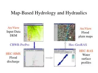
Frequently Used Automated Hydrology Programs • HEC Pre-Pro, University of TX (HEC-HMS) • BASINS, Environmental Protection Agency (HSPF) • GIS Hydro, University of MD (TR-20, USGS Regr.) • WMS, Brigham Young University (TR-20, HEC-HMS, HEC-1, TR-55, Rational Method, USGS Regr.) • MMS, USGS (PRMS)
Automated H&H Watershed Modeling System (WMS) picture courtesy of BOSS International.Used by permission.
Available Automated H&H Packages • Watershed Modeling System (WMS) • River Modeling System (RMS) • RiverCAD • Arc-SWMM • MIKE11 GIS • HEC GeoHMS • GIS Weasel
Available Automated H&H Packages • Watershed Information System (WISE) • Surface Water Modeling System (SMS) • HydroCAD • PC SWMM • RiverTools • BASINS • HEC-RAS/12D
Online Information on Automated H&H • FEMA Flood Hazard Mapping Web Site • http://www.fema.gov/mit/tsd/mm_ahh1.htm • BOSS International WMS Web Site • http://www.bossintl.com/html/wms_overview.html • BOSS International RMS Web Site • http://www.bossintl.com/html/rms_overview.html Note: This does not constitute an endorsement of any specific product by FEMA.
Automated Floodplain Mapping • Applies automated H&H model results • Automates floodplain delineations • Provides for rapid map updating • Georeferences floodplain boundaries and model parameters