Download
1 / 9
90 likes | 208 Views
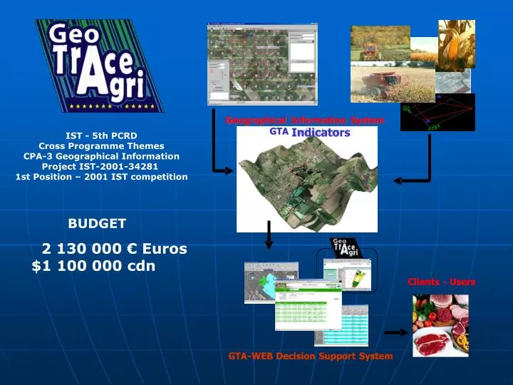
Geographical. Information. System. Geographical. Geographical. Information. Information. System. System. GTA. GTA. Indicators. Indicators. GTA. GTA. Indicators. Indicators. IST - 5th PCRD Cross Programme Themes CPA-3 Geographical Information Project IST-2001-34281

E N D
Geographical Information System Geographical Geographical Information Information System System GTA GTA Indicators Indicators GTA GTA Indicators Indicators IST - 5th PCRD Cross Programme Themes CPA-3 Geographical Information Project IST-2001-34281 1st Position – 2001 IST competition BUDGET 2 130 000 € Euros $1 100 000 cdn Clients Clients - - Users Users GTA GTA - - WEB WEB Decision Decision Support Support System System
Partners AgroMarchés Int. (France) Agrar Online (Germany) Agrinova (UK) Webcattle (Netherlands) Dynaco (Quebec) Innotag (Quebec) NSERC (Canada) CCI Gers (co-ordinator France) Laval University (Quebec) CIRAD (France) CRA Gembloux (Belgium) FUL (Belgium) MRST (Quebec)
Standardisation Labellisation • Délocalisation «sodas» produit déraciné banalisé • Geolocalisation «champagne» produit enraciné identifié Développement local DURABLE du territoire Développement global de marchés
Les 3 enjeux et les 3 objectifs de la géotraçabilité Créer de la valeur ajoutée autour du produit Associer les coordonnées géographiques (x,y…) à toutes informations pertinentes de traçabilité Le consommateur est d’accord pour payer plus cher un produit dont l’origine est garantie Enjeu 1: Qualité et sûreté alimentaire Enjeu 2 : Développement durable GéoTracer pour Qui reposent sur des échanges basés sur des informations géographiques indiscutables et compréhensibles par tous les acteurs de la chaîne Faire la preuve de l’origine géographique du produit et des étapes de sa transformation Enjeu 3 : Mondialisation des échanges Développer de bonnes pratiques professionnelles entre les acteurs de la chaîne Crédibiliser la communication
Les 3 enjeux et les 3 objectifs de la géotraçabilité Créer de la valeur ajoutée autour du produit L’identification en temps réel grâce à une plate forme informatique qui rassemble les données géotracées permet de reconstituer la vie du produit Développement économique et social des zones rurales et protection de l’environnement Enjeu 1: Qualité et sûreté alimentaire Enjeu 2 : Développement durable GéoTracer pour GéoTracer pour L’information géolocalisée est un repère unique pour chaque acteur de la chaîne, elle permet de différencier (segmenter) le produit sur un marché toujours plus grand Enjeu 3 : Mondialisation des échanges Développer de bonnes pratiques professionnelles entre les acteurs de la chaîne Crédibiliser la communication
Delocalisation «Coca Cola » Non-heritage Product Geolocalisation «champagne» Heritage Product Standardized Certification Sustainable Development of the Territory Market Development
Geotraceability: 3 stakes and 3 objectives Generate Product Add value Associate geographical coordinate (X, Y) to all pertinent traceability information Customer agree to pay more for high quality and certificated product stake 1: Quality and Food Security stake 2 : Sustainable Development GeoTrace for Based on incontestable and understandable geographical information exchange within all of the agro-food sectors and actors Proof the geographical origin of the product and is transformation Stake 3 : Globalisation Development of good professional practices between all the actors Reinforce communication and information exchange
Geotraceability: 3 stakes and 3 objectives Generate Product Add value Real time life product identification supported by georeferenced data Economical , social and environmental development of rural region stake 1: Quality and Food Security stake 2 : Sustainable Development GeoTrace for Geographical information is the only reference for agro-food products improvement on the market by all of the actors stake 3 : Globalisation Good professional practices development between all the actors Reinforce Communication
Michel DEBORD Project Manager co-ordinator Michel.Debord@wanadoo.fr Tel 33(0)5 6261 6244 Fax 33(0)5 6261 6263