Download
1 / 1
10 likes | 103 Views
Location, Platform, Instrument. The Air-Sea Interaction Tower (ASIT) is located about 3 km offshore in 15.6 m of water. The SeaPRISM is deployed on ASIT at the Martha's Vineyard Coastal Observatory (latitude=41.3; longitude=70.57).

E N D
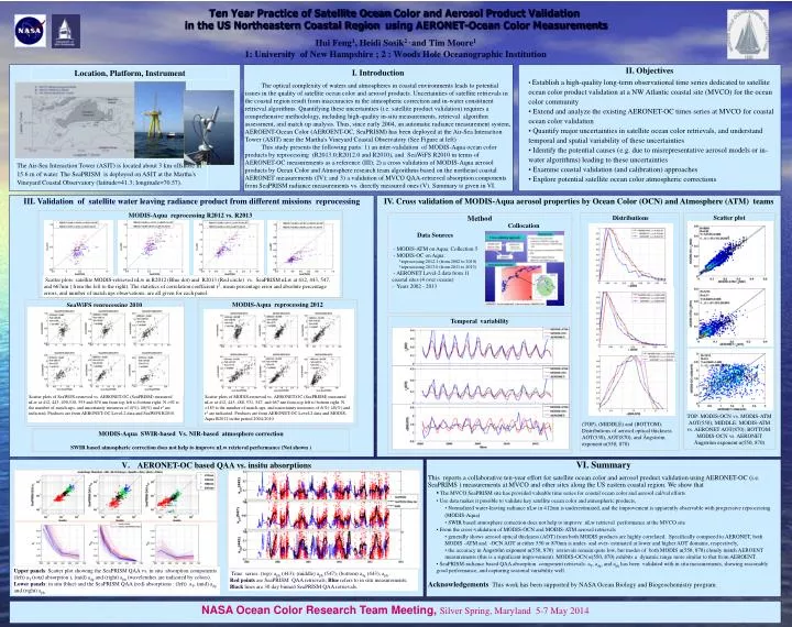
Location, Platform, Instrument The Air-Sea Interaction Tower (ASIT) is located about 3 km offshore in 15.6 m of water. The SeaPRISM is deployed on ASIT at the Martha's Vineyard Coastal Observatory (latitude=41.3; longitude=70.57). Ten Year Practice of Satellite Ocean Color and Aerosol Product Validation in the US Northeastern Coastal Region using AERONET-Ocean Color MeasurementsHui Feng1, Heidi Sosik2 , and Tim Moore1 1: University of New Hampshire; 2 : Woods Hole Oceanographic Institution I. Introduction The optical complexity of waters and atmospheres in coastal environments leads to potential issues in the quality of satellite ocean color and aerosol products. Uncertainties of satellite retrievals in the coastal region result from inaccuracies in the atmospheric correction and in-water constituent retrieval algorithms. Quantifying these uncertainties (i.e. satellite product validation) requires a comprehensive methodology, including high-quality in-situ measurements, retrieval algorithm assessment, and match up analysis. Thus, since early 2004, an automatic radiance measurement system, AEROENT-Ocean Color (AEROENT-OC, SeaPRISM) has been deployed at the Air-Sea Interaction Tower (ASIT) near the Martha's Vineyard Coastal Observatory (See Figure at left) This study presents the following parts: 1) an inter-validation of MODIS-Aqua ocean color products by reprocessing (R2013.0;R2012.0 and R2010), and SeaWiFS R2010 in terms of AERONET-OC measurements as a reference (III); 2) a cross validation of MODIS-Aqua aerosol products by Ocean Color and Atmosphere research team algorithms based on the northeast coastal AERONET measurements (IV); and 3) a validation of MVCO QAA-retrieved absorption components from SeaPRISM radiance measurements vs. directly measured ones (V). Summary is given in VI. • II. Objectives • Establish a high-quality long-term observational time series dedicated to satellite ocean color product validation at a NW Atlantic coastal site (MVCO) for the ocean color community • Extend and analyze the existing AERONET-OC times series at MVCO for coastal ocean color validation • Quantify major uncertainties in satellite ocean color retrievals, and understand temporal and spatial variability of these uncertainties • Identify the potential causes (e.g. due to misrepresentative aerosol models or in-water algorithms) leading to these uncertainties • Examine coastal validation (and calibration) approaches • Explore potential satellite ocean color atmospheric corrections III. Validation of satellite water leaving radiance product from different missions reprocessing IV. Cross validation of MODIS-Aqua aerosol properties by Ocean Color (OCN) and Atmosphere (ATM) teams MODIS-Aqua reprocessing R2012 vs. R2013 Scatter plot s TOP: MODIS-OCN vs. MODIS-ATM AOT(550); MIDDLE: MODIS-ATM vs. AERONET AOT(870); BOTTOM: MODIS-OCN vs. AERONET Ångström exponent α(550, 870) Method Distributions (TOP), (MIDDLE) and (BOTTOM): Distributions of aerosol optical thickness AOT(550), AOT(870), and Ångström exponent α(550, 870) Collocation Data Sources - MODIS-ATM on Aqua: Collection 5 - MODIS-OC on Aqua: *reprocessing 2012.1 (from 2002 to 2010) *reprocessing 2013.0 (from 2011 to 2013) - AERONET Level-2 data from 11 coastal sites (4 over oceans) - Years 2002 - 2013 Scatter plots: satellite MODIS-retrieved nLw in R2012 (Blue dot) and R2013 (Red circle) vs. SeaPRISM nLw at 412, 443, 547, and 667nm ( from the left to the right). The statistics of correlation coefficient r2, mean percentage error and absolute percentage errors, and number of match ups observations, are all given for each panel. MODIS-Aqua reprocessing 2012 SeaWiFS reprocessing 2010 Temporal variability Scatter plots of SeaWiFS-retrieved vs.AERONET-OC (SeaPRISM) measured nLw at 412, 443, 490,510, 555 and 670 nm from top left to bottom right. N =92 is the number of match-ups, and uncertainty measures of δ(%), |δ|(%) and r2 are indicated. Products are from AERONET-OC Level-2 data and SeaWiFS R2010. Scatter plots of MODIS-retrieved vs.AERONET-OC (SeaPRISM) measured nLw at 412, 443, 488, 531, 547, and 667 nm from top left to bottom right. N =185 is the number of match-ups, and uncertainty measures of δ(%), |δ|(%) and r2 are indicated. Products are from AERONET-OC Level-2 data and MODIS-Aqua R2012 in the period 2004-2010. MODIS-Aqua SWIR-based Vs. NIR-based atmosphere correction SWIR based atmospheric correction does not help to improve nLw retrieval performance (Not shown ) • AERONET-OC based QAA vs. insitu absorptions • VI. Summary • This reports a collaborative ten-year effort for satellite ocean color and aerosol product validation using AERONET-OC (i.e. SeaPRIMS ) measurements at MVCO and other sites along the US eastern coastal region. We show that • The MVCO SeaPRISM site has provided valuable time series for coastal ocean color and aerosol cal/val efforts • Use data makes it possible to validate key satellite ocean color and atmospheric products, • Normalized water-leaving radiance nLw in 412nm is underestimated, and the improvement is apparently observable with progressive reprocessing (MODIS-Aqua) • SWIR based atmosphere correction does not help to improve nLw retrieval performance at the MVCO site • From the cross-validation of MODIS-OCN and MODIS-ATM aerosol retrievals • generally shows aerosol optical thickness (AOT) from both MODIS products are highly correlated. Specifically compared to AERONET, both MODIS -ATM and -OCN AOT at either 550 or 870nm is under- and over- estimated at lower and higher AOT domains, respectively, • the accuracy in Ångström exponent α(550, 870) retrievals remain quite low, but modes of both MODIS α(550, 870) closely match AEROENT measurements (this is a significant improvement). MODIS-OCN α(550, 870) exhibits a dynamic range more similar to that from AEROENT. • SeaPRISM-radiance based QAA absorption component retrievals: aT, adg, and aph has been validated with in situ measurements, showing reasonably good performance, and capturing seasonal variability well. • Acknowledgements This work has been supported by NASA Ocean Biology and Biogeochemistry program. Upper panels: Scatter plot showing the SeaPRISM QAA vs. in situ absorption components (left) aT (total absorption ), (mid) adg and (right) aph (wavelenthes are indicated by colors). Lower panels: in situ (blue) and the SeaPRISM QAA (red) absorptions : (left) aT, (mid) adg and (right) aph Time series: (top): aph (443); (middle) aph (547); (bottom) adg (443); aph . Red points are SeaPRISM QAA retrievals; Blue refers to in situ measurements; Black lines are 30 day binned SeaPRISM QAA retrievals. NASA Ocean Color Research Team Meeting, Silver Spring, Maryland 5-7 May 2014