Download
1 / 51

E N D
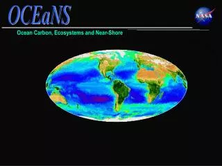
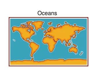
Earth: Water World 70 % of Earth’s surface is covered with water. If all the water on Earth is evenly spread then the depth of the water layer would be about 3.7 km! Luckily the topography of Earth is more complicated and 98% of water are stored in basins, making possible the land mass. “How inappropriate to call this planet Earth, when clearly it is Ocean.” – Arthur C. Clarke –
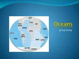
The Arctic Ocean is about 7 percent of the size of the Pacific. The Pacific Ocean is the largest and has the greatest depth. The Indian Ocean, largely a southern hemisphere body, is slightly smaller than the Atlantic. The Atlantic Ocean is about half the size of the Pacific and not quite as deep. The Southern Ocean lies below 60 degrees south. Five Main Ocean Basins
The Pacific Ocean The Pacific Ocean is the largest of the world's five oceans Area: 155.6 million square km; that is, 28 % of the global surface – larger than the total land area of the world Terrain: The ocean floor in the eastern Pacific is dominated by the East Pacific Rise, while the western Pacific is dissected by deep trenches, including the Mariana Trench, which is the world's deepest place Deepest point: Challenger Deep in the Mariana Trench –11,022 m.
Southern Ocean The Southern Ocean, a body of water between 60 degrees south latitude and Antarctica, is the fourth largest of the world's five oceans Area: 20.3 million sq km Terrain: The Southern Ocean is deep – 4,000-5,000 m over most of its extent with only limited areas of shallow water. It holds the world's largest ocean current – the Antarctic Circumpolar Current (21,000 km in length), transporting 130 million cubic metres of water per second, which is 100 times the flow of all the world's rivers Deepest point: 7,235 m at the southern end of the South Sandwich Trench.
Atlantic ocean The Atlantic Ocean is the second largest of the world's five oceans Area: 76.8 million square km Terrain: The ocean floor is dominated by the Mid-Atlantic Ridge, a rugged north-south underwater mountain range stretching down the entire Atlantic basin Deepest point: Milwaukee Deep in the Puerto Rico Trench – 8,605 m.
Arctic Ocean The Arctic Ocean is the smallest of the world's five oceans Area: 14.1 million square km Terrain: The ocean floor is about 50 per cent continental shelf (the highest percentage of any ocean) with the remainder a central basin interrupted by three submarine ridges (Alpha Cordillera, Nansen Cordillera and Lomonosov Ridge) Deepest point: Fram Basin – 4,665 m.
Indian Ocean The Indian Ocean is the third largest of the world's five oceans Area: 68.6 million square km Terrain: The ocean floor is dominated by the Mid-Indian Ocean Ridge and subdivided by the Southeast Indian Ocean Ridge, the Southwest Indian Ocean Ridge and Ninety-east Ridge Deepest point: Java Trench – 7,258 m.
Oldest sedimentary rocks found in Greenland suggest that the early seas were formed about 3,800 million years ago. It is held that ice laden comets and water vapour trapped inside the nascent Earth condensed and resulted into oceans. Origin of Oceans
Salinity Salinity is the total amount of solid material dissolved in water, usually expressed as parts per thousands. Most of the salt in seawater is sodium chloride, common table salt. Chemical weathering of rocks on the continents is the main source of elements found in seawater. Elements from Earth’s interior also seep into seawater.
Salinity Varies Very high Very low Low Very low Low
Natural Processes that Affect Salinity Makes the seawater more saline and more dense. Adds fresh water and makes the sea water less saline and less dense.
Ocean Temperature The average temperature of the oceans is 17ºC. The ocean’s surface water temperature varies with the amount of solar radiation received, which is primarily a function of latitude. The tem is between -2 to 32 !
Temperature Variation with Depth The top 3 m of the ocean hold as much heat as our entire atmosphere.Temperature of the ocean drops suddenly as you go deeper. The layer between the deep water and surface layer is called ‘thermocline’. Temperatures at hydrothermal vents can be as high as 100°C. Most of the seawater at the deep is at freezing temperature of -4°C. The thermocline is the layer of ocean water between about 300 metres and 1,000 metres where there is a rapid change of temperature with depth.
Ocean current is the mass of ocean water that flows from one place to another. Surface currents are movements of water that flow horizontally in the upper part of the ocean’s surface. Surface Current Surface currents develop from friction between the ocean and the wind that blows across its surface. One “rule of thumb” holds that wind blowing for 12 hrs at 100 cm per sec will produce a 2 cm per sec current (about 2% of the wind speed).
Benjamin Franklin was the Deputy Postmaster General of the American colonies and was told of complaints that westward mail from Europe to America took weeks longer than the east-bound ships from America. He being not just a diplomat but also a keen scientist investigated the phenomena. One of the most famous and massive ocean currents, the Gulf Stream, was thus ‘accidentally’ discovered. Mystery of Atlantic Ships
Gulf Stream On examination of the ships’ records with the help of Capt. Timothy Folger he found that it was indeed true that onward journey from Europe took two weeks longer than the return journey.Compiling the drift data from various ships that sailed the Atlantic he was able to accumulate information on the ocean currents off the US East Coast. Thus he identified the ‘Gulf Steam’, which he called a ‘river in the ocean’ and depicted it in a map prepared in In the 1769.
Surface Currents Currents are like rivers in the oceans. They can carry enormous amounts of water. For example, the Antarctic Circumpolar Current can transport 100 million cubic metres of seawater per second! Some currents containing mud travel at speeds of 4 m/sec. They are known to have transported blocks weigh-ing as much as 9,000 kg! Water currents transport heat, sediment particles, dissolved oxygen and nutrient elements from one place to another. The Somali Current, off Africa's eastern coast, is unusual because it reverses direction twice a year. From May to September it runs north; from November to March it runs south.
Gyres are huge circular-moving current systems that dominate the surfaces of the oceans. TheCoriolis Effect is the deflection of currents away from their original course as a result of Earth’s rotation. Gyres
Mechanism of Surface Current Winds driven by uneven solar heating and Earth spin drives ocean currents. Due to surface winds water moves in different directions.
Gyres Surface winds, Sun’s heat, Coriolis Effect and gravity circulates the ocean surface clockwise in Northern hemisphere and anti-clockwise in Southern hemisphere. Wind-driven currents occur in the uppermost 100 m or less. There is another current that flows in the deep. Density differences causes by salinity and temperature produce very slow flows in deeper waters. Four interconnected currents result in a gyre.
and then emerge as up-swelling south of India and Pacific. Cold and salty water would rush to deepocean….. Once at surface, the water is heated up and travels west again. and combine with cold water off Antarctica….. moves east, channelled by deep sea trenches and mid ocean ridges Deep Water Currents- Ocean conveyor belt Densitycurrents are vertical currents of ocean water that result from density differences among water masses. An increase in seawater density can be caused by a decrease in temperature or an increase in salinity.
Ocean Conveyor Belt The deep ocean conveyor belt transports nutrients and heat across the globe. As can be seen in the map, Europe is about 10 degrees hotter than the rest of the places in the same latitude due to the heat transported by the ocean’s conveyor belt .
Breaking waves occur as a wave moves onto shore. As the waves touch the bottom, wave speed decreases. The decrease in wave speed results in a decrease in wavelength and an increase in wave height. Waves and Surf Most ocean waves obtain their energy and motion from the wind. The height, length, and period that are eventually achieved by a wave depend on three factors: (1) wind speed, (2) length of time the wind has blown, and (3) fetch – distance wind travelled in open water. Circular orbital motion allows energy to move forward through the water while the individual water particles that transmit the wave move around in a circle.
Tides Gravitational attraction of Sun and Moon causes the ocean water to bulge resulting in tides. Watch the animation
But when Sun and Moon are at angle tides caused are highest low tide and lowest high tide Tides During New and Full Moon phases the Moon, Sun, and Earth are aligned causing a greater gravitational pull on Earth. This results in higher high tides and lower low tides, which are known as Spring Tides.
Oceans as a Source of Water Vapour Makes rain and monsoon possible….
How are Cyclones formed Cool air rushes in to fill the void. Due to rotation of the Earth on its axis, the air is bent inwards and then spirals upwards with great force. The swirling winds rotate faster and faster, forming a huge circle about 2,000 km across. As the cyclone builds up it moves. Warm, moist air sustains it. The strongest winds and heaviest rains are found in the towering clouds. Winds can reach speeds of up to 200 km/h, pumps out about two million tonnes of air per second. At the centre of the storm is a calm, cloudless area called the eye, where there is no rain, and the winds are fairly light. Cyclones develop over warm seas near the Equator. Air heated by the sun rises very swiftly, which creates areas of very low pressure. As the warm air rises, it becomes loaded with moisture which condenses into massive thunderclouds.
Cyclones, Hurricanes…. Due to Earths rotation and Coriolis force cyclones rotate anti clockwise in northern hemisphere and clockwise in southern hemisphere Due to Global warming as the sea surface temperature is increasing, the intensity of cyclones and hurricanes are expected to increase resulting in severe damage Hurricane Katrina (2005) that hit US anti-clockwise swirl Cyclone Larry (2006) that hit Australia with clockwise swirl.
Till recently large part of the world map was just coloured blue – as we had scant knowledge of what is beneath it. Developments in technology made possible to look at the ocean surface. It is said that we know lot more about Moon than what is under the oceans. The entire surface of the Moon has been mapped.
Ocean floor is mapped by using SONAR (an acronym for sound navigation and ranging). It is also referred to as echo sounding. Sonar works by transmitting sound waves toward the ocean bottom. Mapping the Ocean Floor
Today Satellites Help Satellites are able to measure small differences by bouncing microwaves off the ocean surface. Using this new technology, scientists have discovered that the ocean surface is not perfectly flat. Differences in the height of the ocean surface are caused by ocean-floor features.
Deepest point 11,033 m in the Mariana Trench in the western Pacific. Mauna Kea, Hawaii, rises 10,203 m from its base on the ocean floor; only 4,170 m are above sea level. The Great Barrier Reef, measuring about 2,000 km, is the largest living structure on Earth. It can be seen from the Moon. The Antarctic ice sheet that forms and melts over the ocean each year is nearly twice the size of the United States The largest single feature on Earth, the ocean ridges 64,000 km long, weaves its way through all the major oceans. Unravelling the Ocean Floor
The ocean basin floor is the deep-ocean floor between the continental margin and the oceanic ridge. A continental margin is the zone of transition between a continent and the adjacent ocean basin floor. Deep-ocean trenches form at the sites of plate convergence where one moving plate descends beneath another and plunges back into the mantle. Cross-section of a Typical Ocean
Sonar readings based on which ocean floor is mapped in detail Computed Ocean surface features Ocean Floor Features An abyssal plain is a very level area of the deep-ocean floor, usually lying at the foot of the continental rise. A seamount is an isolated volcanic peak that rises at least 1,000 metres above the deep-ocean floor, and a guyot is an eroded, submerged seamount.
Continental Shelf A continental shelf is the gently sloping submerged surface extending from the shoreline. Continental shelves contain important mineral deposits, large reservoirs of oil and natural gas, and huge sand and gravel deposits.
Deep Zone: Sunlight never reaches this zone. Temperatures are just a few degrees above freezing. Constant high-density water. More than 90% of the living space in oceans exists in the deep ocean known as the abyss. Mixed Zone: Shallow (300 to 450 meters) Zone of mixingandSun-warmed zone Transition zone: Between surface layer and deep zone Layers of Ocean Water Oceanographers generally recognise a three-layered structure in most parts of the open ocean
Life In Ocean From microscopic life forms thousands of which can be fitted into millimetre to the largest mammal – blue whale – 33 metres across, are abundant in oceans. Marine life comes in different shapes and sizes. Oceans contain 99% of the living space on the planet. 80 % of life on Earth is found under the ocean surface. Less than 10% of that space has been explored by humans.
Life Form Differs as You go Deep Because of the three- dimensional space available in ocean it is estimated that available living space for marine organism is 250 times greater than for that on land. Yet most of the marine organisms are concentrated near the surface, in the upper 200 m where sunlight penetrates.
The photic zone is the upper part of the ocean into which sunlight penetrates. The pelagic zone is open zone of any depth. Animals in this zone swim or float freely. The benthic zone is the marine-life zone that includes any sea-bottom surface regardless of its distance from shore. The abyssal plain is a subdivision of the benthic zone characterised by extremely high pressures, low temperatures, low oxygen, few nutrients, and no sunlight. Life in Ocean
Adaptation to Ocean Features Life in ocean is specially adapted to the saline condition as well as the massive pressure in the ocean,
Hydrothermal Vents Hydrothermal vents form along mid-ocean ridges. These are zones where mineral-rich water, heated by the hot, newly-formed oceanic crust, escapes through cracks in the oceanic crust into surrounding water. These vents harbour communities of organisms found nowhere else on Earth. Unique organisms found here produce food through chemosynthesis – process using chemical energy to create inorganic nutrients – as distinct from photosynthesis. Giant Tube worms
Indian coast • India's coast is 7,517 km long; of this distance, 5,423 km- mainland 2,094 km Andaman, Nicobar, and Lakshadweep Islands. • 43% of mainland coast is sandy beaches, 11% rocky coast including cliffs, and the rest 46% mudflats or marshy coast. • Among notable coastal features of India are the marshy Rann of Kutch in western India, and the alluvial Sundarbans delta, which India shares with Bangladesh. • India has two archipelagos: the Lakshadweep, coral atolls off India's south-western coast; and the Andaman and Nicobar Islands, a volcanic chain in the Andaman Sea. • About 26% of Indian population live within 100 kms of the coast. • The area of continental shelf is about 372424 km2. The territorial sea extends to 193834 km2 while the claimed exclusive economic zone is 2103415 km2. • 3036 km2 of coastal region is mangrove forest and there are about 1930 km2 of wetland in the coastal region. • Total fish catch during 2000 was about 2773092 metric tons which provided about 5 kg per capita per year.
Oil and natural gas are the main energy products currently being obtained from the ocean floor. Gas hydrates are compact chemical structures made of water and natural gas. Most oceanic gas hydrates are created when bacteria break down organic matter in ocean-floor sediments. Other major resources from the ocean floor include sand and gravel, evaporative salts, and manganese nodules (hard lumps of manganese and other metals like cobalt, copper, and iron) that precipitate around a small object. The offshore sand-and-gravel industry is second in economic value only to the petroleum industry. Ocean’s Bounty The most economically important resource is, of course, salt!
Economic Importance of Oceans More than 90 % of the trade between countries is carried by ships and about half the communications between nations use underwater cables. Fish supply the greatest percentage of the world's protein consumed by humans. Most of the world's major fisheries are being fished at levels above their maximum sustainable yield; some regions are severely overfished.
Oceans Sustain Life Three-quarters of the world's mega-cities are by the sea. By 2010, 80% of people will live within 50 km of the coast. More than 3.5 billion people depend on the ocean for their primary source of food. In 20 years, this number could double to 7 billion.
Oceans Under Threat Over the past decade, an average of 600,000 barrels of oil a year has been accidentally spilled into the oceans from ships. More oil reaches the oceans each year as a result of leaking automobiles and other non-point sources than spills. Eighty per cent of all pollution in seas and oceans comes from land-based activities. Plastic waste kills up to 1 million sea birds, 100,000 sea mammals and countless fish each year. Plastic remains in our ecosystem for years harming thousands of sea creatures everyday. Death and disease caused by polluted coastal waters costs the global economy US$12.8 billion a year. The annual economic impact of hepatitis from tainted seafood alone is US$7.2 billion.
Ocean may die… Change in sea surface pH caused by anthropogenic CO2 between the 1700s to 1990s Due to increase in Carbon dioxide levels in the atmosphere the levels of carbon uptake in sea has increased leading to acidification of ocean. Between 1751 and 1994 surface ocean pH is estimated to have decreased from approximately 8.179 to 8.104 (a change of -0.075). If such trend continues it will cause immense damage to life in ocean