Download
1 / 24
240 likes | 342 Views
USGG2003 & GEOID03. Northeast States Geodetic Conference Daniel R. Roman, Ph.D. Research Geodesist. DISCUSSION OUTLINE. Background on Geodetic Datums/Models USGG2003 – Base Model for GEOID03 GPSBM2003 – Control Data Single Gaussian Matrix Model (GEOID99) Multi-Matrix Model (GEOID03)

E N D
USGG2003&GEOID03 Northeast States Geodetic Conference Daniel R. Roman, Ph.D. Research Geodesist
DISCUSSION OUTLINE • Background on Geodetic Datums/Models • USGG2003 – Base Model for GEOID03 • GPSBM2003 – Control Data • Single Gaussian Matrix Model (GEOID99) • Multi-Matrix Model (GEOID03) • Results from Single Gaussian Model • Results from Multi-Matrix Model • Summary
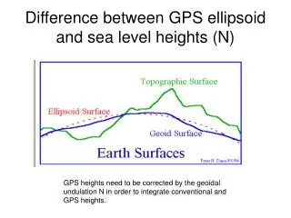
Background • Mean Sea Level (MSL) is the best reference for a height datum • The “geoid” describes the undisturbed equipotential surface of the oceans • Gravity Anomalies can be related to the geoid through a mathematical relationship • The U.S. vertical datum, NAVD 88, is a realization of that equipotential surface
“P” 0 Deflection of Vertical h = H + N Normal to geoid Normal to ellipsoid “P” H h Geopotential Surface “Ellipsoid” “Q” N Geopotential Surface “Geoid” Geopotential Surface Earth’s Surface OCEAN
Ref. FAGA Ref. Und. Res. FAGA Res. Und. Ref. Mdl Obs. FAGA Stokes Geoid Processing Flow Chart(Simplified) Gravimetric Geoid
Least Squares Collocation Using a Multiple (Two) Gaussian Functions
MMLSC Modeled Geoid Height Signal Between GPSBM2003 and USGG2003
Final Fit Between GPSBM2003 and Multi-Matrix Model (GEOID03)
Final Unmodeled Geoid Height Signal Between GPSBM2003 and Single-Matrix Model
Final Unmodeled Geoid Height Signal Between GPSBM2003 and MMLSC Model
Statistics for NE States • State # Points MIN MAX AVE STD • (m) (m) (m) (m) • CT 20 -0.024 0.025 0.000 0.013 • DE 33 -0.054 0.041 0.000 0.024 • MA 40 -0.048 0.042 -0.000 0.020 • MD 400 -0.075 0.071 -0.001 0.020 • ME 66 -0.060 0.092 0.000 0.024 • NH 16 -0.062 0.106 0.005 0.038 • NJ 275 -0.077 0.051 0.000 0.015 • NY 130 -0.052 0.065 -0.000 0.018 • PA 98 -0.090 0.117 0.000 0.024 • RI 22 -0.026 0.083 -0.001 0.023 • VT 327 -0.059 0.086 0.000 0.018 • all NE 1427 -0.090 0.117 -0.000 0.019 • CONUS 14185 -0.205 0.227 -0.000 0.024
GPS Obs. Short/Int. Statewide adjustments (HARNs) CORS National re-adjustment Gravimetric Geoid Faye anomalies DEM resolution and accuracy Remove-and- Restore (EGM96) 1D FFT solution New DEM/gravity Combined data & Fourier solution Error Sources • Leveling (BM) • Long/Int. • Quality of initial gravity • The effect is greatest in the mountains • Propagation • GPS/Leveling
Summary & Outlook • More complex models of the Gaussian function better emulate GPSBM residuals • Further near term improvements will derive from readjusting and improving input data • Long term improvements require revising the entire approach taken to generate the underlying gravimetric geoid