Download
1 / 31
310 likes | 317 Views
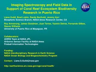
Imaging Spectroscopy and Field Data in Support of Coral Reef Biodiversity and Change Research in Puerto Rico. Liane Guild, Brad Lobitz, Randy Berthold, Jeremy Kerr Biospheric Science Branch, NASA Ames Research Center, CA

E N D
Imaging Spectroscopy and Field Data in Support of Coral Reef Biodiversity and Change Research in Puerto Rico Liane Guild, Brad Lobitz, Randy Berthold, Jeremy Kerr Biospheric Science Branch, NASA Ames Research Center, CA Roy Armstrong, James Goodman, Yasmine Detres, Fernando Gilbes, Stacey Williams University of Puerto Rico at Mayaguez, PR Collaborators: AVIRIS Team at NASA JPL Airborne Science and Technology Lab at NASA Ames Fireball Information Technologies Funding: NASA Interdisciplinary Research in Earth Science NASA Ocean Biology and Biogeochemistry Program Contact: Liane.S.Guild@nasa.gov http://earthscience.arc.nasa.gov/sge/coral-health/
Science Objectives • Use NASA’s 2005 AVIRIS imagery over La Parguera, PR to map coral reef benthic types and variability • Establish permanent reef monitoring transects to track change annually • Use AVIRIS data and field measurements to assess the ecological impact of the 2005 coral bleaching event in Southwestern Puerto Rico • Hurricane Dean in August 2007 • Improve the interpretation of reef habitat variability and biodiversity from imaging spectroscopy (hyperspectral) data • Processing algorithms could be used for future HyspIRI data
Climate Change Threats: Increased Sea Temperatures • Due to sustained high sea temperatures, zooxanthellae (photosynthetic algae of coral) are expelled, leaving the coral “bleached”. • Coral species of interest: Acroporids (elkhorn and staghorn coral) were listed as threatened in 2006 under the US Endangered Species Act (ESA). • This year 7 additional • Caribbean coral reef • species (75 Pacific spp) • are under review for • listing; all found in PR Healthy A. cervicornis Bleached A. palmata Healthy Acropora palmata Mostly dead A. cervicornis
NOAA Coral Reef Watch: SST Degree Heating Weeks Oct. 22, 2005
NASA Airborne Missions of Coral Reefs Using AVIRIS and DCS • AVIRIS (Airborne Visible Infrared Imaging Spectrometer): • Operated by NASA Jet Propulsion Lab • NASA Wallops Twin Otter • 224 contiguous spectral channels (370-2500 nm) • Visible range: 410-700 nm (31 bands) • 10 nm nominal channel bandwidth • High signal to noise ratio • Altitude: ~ 3.5 km (Twin Otter) • AVIRIS spatial resolution: ~ 3 m (Twin Otter), ~16 m (ER-2) • Cirrus and Kodak DCS(Digital Camera System) on low altitude aircraft • Cirrus: Operated by UC Santa Cruz Airborne Sensor Facility at NASA Ames • Kodak: Operated by NASA Ames and Fireball Information Technologies • Spatial resolution: <1 m
NASA Airborne Mission of the 2005 Caribbean Coral Reef Bleaching Event Using AVIRIS and DCS AVIRIS flight lines over La Parguera, PR • December 12-13, 2005 • Twin Otter Platform, Altitude ~3.5 km • Pixel Size ~3 m
Kodak DCS Imagery of San Cristobal, La Parguera 30 cm resolution AVIRIS 3 m resolution ETM+ ~30 m resolution
Field Measurements • Airborne reflectance spectra are composites of reflectance from: • the atmosphere (air molecules, particulates, aerosols); • the sea surface; • the water column (water molecules, phytoplankton, colored dissolved organic matter); and • the bottom (sediments, seagrass, corals). • Atmospheric constituents are measured with sunphotometers. • Water column optical properties are measured with spectrophotometers. • Spectroradiometers are used to measure light reflected from the sea surface, the coral reef bottom types, and within the water column. 1 radiance 2 3 water optics spectrophotometer Spectroradiometer field spectra 4
Field Measurements • Reef benthic type spectra • Photogrids • GPS • Spectra of calibration targets • Aeronet station – AOD atmospheric correction • Water optical profiler • Upwelling radiance, Lu • Downwelling irradiance, Ed • Surface Ed, Es
Coral Reef Ecosystem Benthic Types Coral Rubble Acropora cervicornis Acropora palmata Montastraea annularis Siderastrea siderea Porites spp. Dictyota spp. Thalassia testudinum Gorgonians
Field Spectra and Spectral Resolution • Spectra normalized to unity at 550nm show differences in spectral shape between benthic cover types • Live coral has a broad peak between green and red wavelength • Most features show a chlorophyll absorption feature at 680nm
AVIRIS Dec. 2005 (3 m Resolution) Mosaic of La Parguera, PR
LiDAR Bathymetry and Field Measurement Locations • Airborne data collection 2006 • Bathymetry 50m • 4m spatial resolution
J. Goodman (UPRM) Raw AVIRIS Imagery Image Geometry Explicit pixel by pixel subsurface angles Illumination (solar) View (AVIRIS) 2005 AVIRIS: Preprocessing and Inversion Model Image Preprocessing Correct Stray Light Anomaly Hedley Glint Removal Tafkaa Atmospheric Correction Inversion Output Water Properties Spectral Input Parameters Aquatic Absorption Properties Generic Bottom Reflectance Inversion Model Bathymetry Bottom Albedo (550 nm)
J. Goodman (UPRM) Preprocessed AVIRIS Imagery Inversion Output Water Properties Bathymetry Spectral Input Parameters Aquatic Absorption Properties Generic Bottom Reflectance Image Geometry Explicit pixel by pixel subsurface angles Illumination (solar) View (AVIRIS) 2005 AVIRIS: Unmixing Model Spectral Endmembers Unmixing Output Benthic Composition Forward Model Sand Unmixing Model Coral Algae/ Seagrass
Mixed live/dead branching Mixed live/dead massive coral Solitary colonies, SAV, sand SAV coral mix SAV Sand Breaker 2005 AVIRIS: From Imagery to Information Preprocessed AVIRIS Image Inversion and Unmixing Hydrolight Transformation Unmixing End-Member-Index Classification Preprocessed Spectral Classification Hydrolight Spectral Classification
Acropora cervicornis (staghorn coral) Transects 2004-2007 2005 2004 2006 2007
Acropora cervicornis (staghorn coral) Transects 2008 2008 2009
Reef Bottom Type Biodiversity (Percent Cover) Coral Point Count with Excel Extensions (CPCe)
Reef Bottom Type Biodiversity (Percent Cover) • Coral and gorgonian cover was not significantly different from 2007 to 2009 • Sponge cover has increased • Macroalgae increased in 2008 then decreased in 2009 • Sand cover decreased from 2007 to 2008 and 2009 level • Recovery possibly beginning in benthic communities at some sites • Results are similar to other studies following disturbances in coral reefs • Need at least two more years of monitoring to confirm occurrence of recovery
Summary and Next Steps http://earthscience.arc.nasa.gov/sge/coral-health/ • Generalized spectral categories (coral, sand, and SAV) used as inputs to the models still allowed for detailed output classes (ecological zones) • Use detailed benthic spectral library for unmixing end members • Compare spectral transects with Hydrolight-transformed AVIRIS data • Substantial image preprocessing may have affected the modeling results • Biodiversity analysis, based on percent cover within photogrids acquired in 2007-2009, showed recovery possibly beginning in benthic communities at some sites • Complete photogrid analysis for other patch reefs and relate 2005 transects with AVIRIS classifications • Complete assessment of changes in biodiversity, perhaps related to recovery from 2005 bleaching event and 2007 hurricane • Critical need for hyperspectral data for studies in shallow water • Procedures relevant to HyspIRI
Remote Sensing Challenges: Spatial Resolution Montastraea annularis (pale) following 2005 bleaching
Background • Coral reefs are in peril: • rapidly growing local populations • regional to global atmospheric, oceanographic and climatic changes • increased sea temperatures, rising CO2 and falling pH (ocean acidification) • increased frequencies, intensities and distributions of bleaching, disease and other disturbances • deteriorating biologically and physically • loss of hard corals, increased abundance of algae, replacement of corals by algae, predation and microbial outbreaks • 2 species listed as “threatened” under the US Endangered Species Act (2006) and 83 additional species are proposed for listing (2009) with final determination in 2010
Field Data Collection Cirrus DCS Imagery (< 1m resolution) Buck Island, St. Croix, USVI December 16, 2005 Calibration tarp and boat are visible!
US Coral Reef Task Force: NASA Airborne Mission of the 2005 Caribbean Coral Reef Bleaching Event Using AVIRIS and DCS • Airborne Mission 2005 • Culebra, PR, Dec. 12 • La Parguera, PR, Dec. 12-13 • Buck Island, St. Croix, Dec. 15-16 • St. John, Dec. 19 • Vieques Is., PR, Dec. 20 • Research Objective • Assess the ecological impact of coral bleaching in Puerto Rico and the USVI DCS imagery of Buck Island, USVI, December 2005 This collaborative effort was in support of the US Coral Reef Task Force’s (USCRTF) November 2005 resolution to mobilize and assess coral reef bleaching, coral mortality, coral recovery, and the ecological impact of the September-October 2005 coral bleaching event in Puerto Rico (PR) and the US Virgin Islands (USVI).
Water Column Spectral Attenuation Spectral attenuation coefficients (Kd) can be determined by using Satlantic Hyperpro downwelling irradiance (Ed) profiles. These measurements can be expressed as a function of depth.
J. Goodman (UPRM) 2005 AVIRIS: From Imagery to Information Raw Image Bottom Albedo Benthic Composition Bathymetry
J. Goodman (UPRM) 2005 AVIRIS: From Imagery to Information Sand Algae/ Seagrass Coral AVIRIS Data Field Data + DCS Images Benthic Composition
89 categories • Corals: 52 species • Macroalgae: 13 genera • Gorgonians: 11 genera • Dead coral with algae (4); Zoanthids (2); Coralline algae (1); Sponges (1); Other live (1); Diseased corals (1)