Download
1 / 42
420 likes | 424 Views
Learn about the United States' territorial acquisitions in the southwest during the Mexican-American War, as shown in the Treaty of Guadalupe Hidalgo. Explore the causes and consequences of this war.

E N D
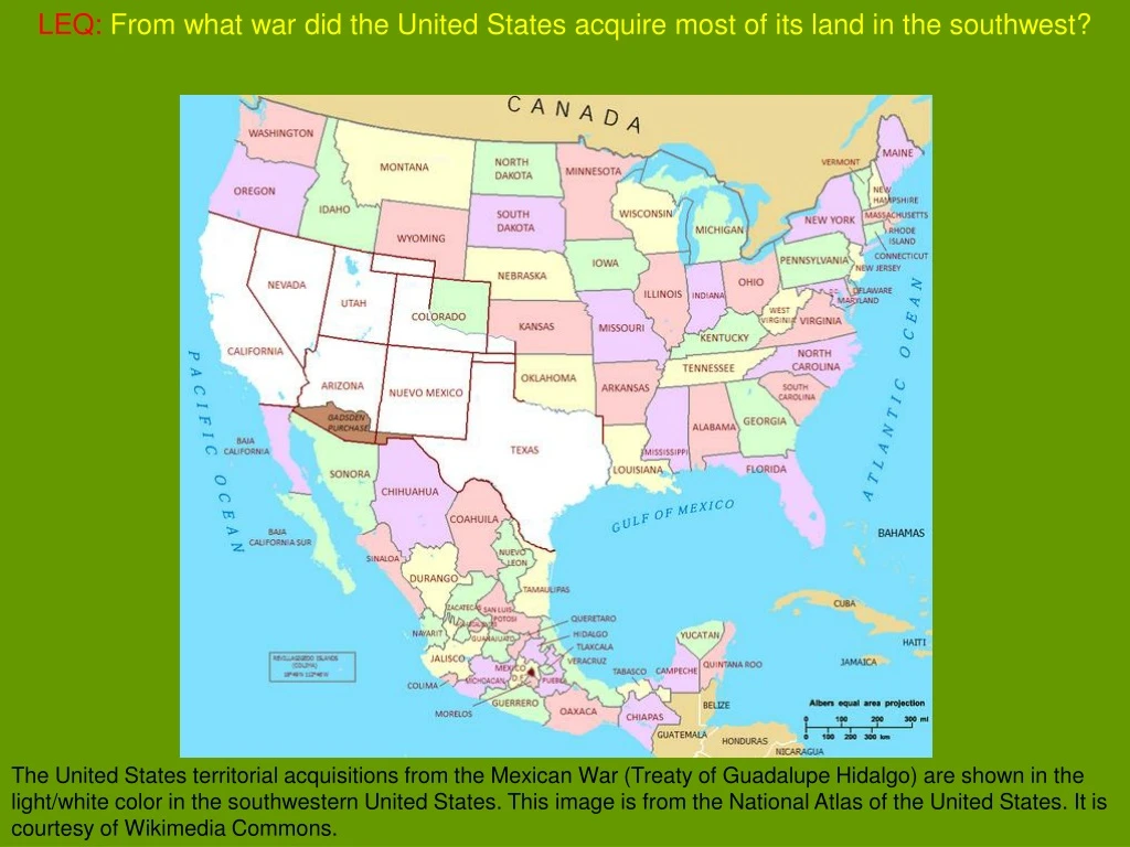
LEQ:From what war did the United States acquire most of its land in the southwest? The United States territorial acquisitions from the Mexican War (Treaty of Guadalupe Hidalgo) are shown in the light/white color in the southwestern United States. This image is from the National Atlas of the United States. It is courtesy of Wikimedia Commons.
LEQ:From what war did the United States acquire most of its land in the southwest?Mexican-American War The United States territorial acquisitions from the Mexican War (Treaty of Guadalupe Hidalgo) are shown in the light/white color in the southwestern United States. This image is from the National Atlas of the United States. It is courtesy of Wikimedia Commons.
The Mexican-American War This painting shows the Battle of Chapultepec during the Mexican-American War. Chapultepec Castle was an important position in the defense of Mexico City. It was also the home of the Mexican Military Academy, which had cadets as young as 13 years old. The American victory at Chapultepec drove the Mexican army back into Mexico City. The original drawing was made by Carl Nebel the lithograph was made by Adolphe Jean-Baptiste Bayot (1810-1866). It was published in 1851 The War Between the United States and Mexico, Illustrated. This image is courtesy of Wikimedia Commons.
LEQ:From what war did the United States acquire most of its land in the southwest? The United States territorial acquisitions from the Mexican War (Treaty of Guadalupe Hidalgo) are shown in the light/white color in the southwestern United States. This image is from the National Atlas of the United States. It is courtesy of Wikimedia Commons.
LEQ:From what war did the United States acquire most of its land in the southwest?Mexican-American War The United States territorial acquisitions from the Mexican War (Treaty of Guadalupe Hidalgo) are shown in the light/white color in the southwestern United States. This image is from the National Atlas of the United States. It is courtesy of Wikimedia Commons.
Because many people in the northern United States opposed entry of another slave state into the Union, Texas continued to exist as an independent country. This map shows the free states in blue and the slave states in gray in 1860. This is courtesy of the National Park Service’s Lincoln Home National Historic Site.
The governments of Mexico and Texas quarreled over borders and territory. The area in green shows the disputed territory between the Republic of Texas and Mexico. This image by Ch1902 is courtesy of Wikimedia Commons.
Many Americans believed that their nation had a Manifest Destiny. This painting shows "Manifest Destiny" (the religious belief that the United States should expand from the Atlantic Ocean to the Pacific Ocean in the name of God). In 1872 artist John Gast painted a popular scene of people moving west that captured the view of Americans at the time. This image is courtesy of Wikimedia Commons.
Those Americans believing in Manifest Destiny thought that their Christian God wanted them to expand across the continent from the Atlantic Ocean to the Pacific Ocean. This image, titled Westward the Course of Empire Takes Its Way was painted by Emanuel Leutze in 1860. This image is courtesy of Wikimedia Commons.
Most white Southerners strongly supported extending their cotton-growing area by annexing Texas. This painting is titled A Cotton Plantation on the Mississippi. This image was created in 1848 by W.A. Walker. It was published by Currier & Ives in 1884. This image is courtesy of the Library of Congress.
Northern abolitionists, however, opposed adding another slave state to the Union. This is the official medallion of the British Anti-Slavery Society. It was created in 1795 by Josiah Wedgwood (1730-1795) as a jasper-ware cameo at his pottery factory. The design for the cameo is attributed to William Hackwood or to Henry Webber, who were both modelers at the Wedgewood factory. This image is courtesy of Wikimedia Commons.
In December, 1845, Texas became the twenty-eighth state to enter the Union; however, some problems still had to be resolved. The Seal of the State of Texas was adopted through the 1845 Texas Constitution, and was based on the seal of the Republic of Texas, which dates from January 25, 1839. The 1845 Texas Constitution states, "There shall be a seal of the State, which shall be kept by the Governor and used by him officially. The seal shall have a star of five points, encircled by olive and live oak branches, and the words 'the State of Texas.'“.This image is courtesy of Wikimedia Commons.
President James K. Polk instructed his minister to Mexico to convince Mexico to accept the Rio Grande as the southern border of Texas. This image is titled Texas and the Territory in Dispute. It was published by William Bagley and Charles Beard in The History of the American People. Sacramento: California State Printing Department, 1920. This image is courtesy of ushistoryimages.com.
The American Minister, John Slidell also offered the Mexicans $5 million for the Rio Grande boundary, and $25 million to purchase California. John Slidell (1793-1871) was a native of New York who moved to Louisiana as a young man. While in Louisiana, this lawyer and businessman became a U.S. Representative and a U.S. Senator. He was sent by President Polk to negotiate the southern boundary of Texas with Mexican officials before the Mexican War, and to offer $30 million for California and Texas. This photograph was taken by Mathew Brady’s National Portrait Gallery circa 1861-1865 and is courtesy of Wikimedia Commons.
Mexican officials thought that the amount of money offered was too low, considered the offer an insult, and refused to even speak with Slidell. This map shows the size of Mexico in 1845. This image is courtesy of Wikimedia Commons.
American soldiers under the command of General Zachary Taylor crossed the Nueces River and set up posts just north of the Rio Grande. This image is titled Captain Walker’s Expedition. This image was published in John Frost’s Pictorial History of Mexico and the Mexican War. Richmond, VA: Harold and Murry, 1848. This image is courtesy of ushistoryimages.com.
Although Texas claimed the Rio Grande as its southern boundary, Mexico considered it to be in Mexican territory. This photograph shows the Rio Grande near San Francisco Creek. This image shows a United States Geological Service survey party in Brewster County, Texas on October 28, 1899. This image is courtesy of the U.S. Geological Survey Photographic Library, and of Wikimedia Commons.
In April, 1846, Mexican soldiers attacked a United States cavalry patrol and killed 11 Americans. This image is titled “Defeat of American Dragoons at the Battle of Resaca De La Palma.” This image is from Edward Ellis’ The History of Our Country: From the Discovery of America to the Present Time. Cincinnati: The Jones Brothers Publishing Company, 1910. This image is courtesy of ushistoryimages.com.
President Polk announced that “Mexico has… shed American blood on American soil.” James Knox Polk (1795-1849) was the 11th President of the United States. He was born in North Carolina, but was a resident of Tennessee at the time of his elevation to the Presidency. This painting by Minor K. Kellogg (1814-1889) was produced in 1846. This image is courtesy of Wikimedia Commons.
Both houses of Congress voted by a large majority to declare war on Mexico. This is a model showing the United States Capitol as completed by Charles Bullfinch in 1829. When Charles Bulfinch was appointed the third Architect of the Capitol in 1818, the Capitol had been under construction for 25 years. His principal contributions to the exterior appearance of the Capitol are the west central building, the copper-covered wooden dome, and the landscaped grounds enclosed by an iron and stone fence. Bulfinch built the east central portico using Thornton's design as modified by Benjamin Latrobe. This is the east front of the Capitol. This image is courtesy of the Architect of the Capitol.
Many abolitionists considered the war a Southern plot to add more slave states to the Union. This is a campaign poster for the Free Soil Party candidates Martin Van Buren and Charles Francis Adams in the Presidential Election of 1848. It was created by the Nathaniel Currier firm. This image is courtesy of the Library of Congress and Wikimedia Commons.
Most American newspapers, though, rallied behind President Polk. Among other articles in this newspaper, General Zachary Taylor’s victory at the Battle of Buena Vista is covered in this issue. This image is courtesy of mynotera.com.
LEQ:From what war did the United States acquire most of its land in the southwest? The United States territorial acquisitions from the Mexican War (Treaty of Guadalupe Hidalgo) are shown in the light/white color in the southwestern United States. This image is from the National Atlas of the United States. It is courtesy of Wikimedia Commons.
LEQ:From what war did the United States acquire most of its land in the southwest?Mexican-American War The United States territorial acquisitions from the Mexican War (Treaty of Guadalupe Hidalgo) are shown in the light/white color in the southwestern United States. This image is from the National Atlas of the United States. It is courtesy of Wikimedia Commons.
United States General Zachary Taylor and his army crossed the Rio Grande into Mexico. This painting shows United States soldiers commanded by Zachary Taylor marching on Monterrey, Mexico during the Mexican War. The original drawing was made by Carl Nebel the lithograph was made by Adolphe Jean-Baptiste Bayot (1810-1866). It was published in 1851 The War Between the United States and Mexico, Illustrated. This image is courtesy of Wikimedia Commons.
The Mexican President, Santa Anna, personally led an army against Taylor. Zachary Taylor (1784-1850) was the twelfth President of the United States. His victories during the Mexican war helped elect him to the office of President. He was the second President to die in office. This painting was created by James Reid Lambdin in 1848. This image is courtesy of Wikimedia Commons.
Zachary Taylor’s army defeated Santa Anna at the Battle of Buena Vista. The Battle of Buena Vista (February 23, 1847), saw the United States Army use artillery to repulse the much larger Mexican army. Buena Vista is located in northern Mexico. The original drawing was made by Carl Nebel the lithograph was made by Adolphe Jean-Baptiste Bayot (1810-1866). It was published in 1851 The War Between the United States and Mexico, Illustrated. This image is courtesy of Wikimedia Commons.
Another American General, Winfield Scott, landed troops on the Gulf Coast near Veracruz. The Battle of Veracruz was a 20-day siege of the key Mexican beachhead seaport of Veracruz. it began with the first large-scale amphibious assault conducted by United States military forces, and ended with the surrender and occupation of the city. U.S. forces then marched inland to Mexico City. The original drawing was made by Carl Nebel the lithograph was made by Adolphe Jean-Baptiste Bayot (1810-1866). It was published in 1851 The War Between the United States and Mexico, Illustrated. This image is courtesy of Wikimedia Commons.
Winfield Scott’s army marched to the west, and, after Mexicans made a heroic last stand, Scott took over Mexico City. This painting is titled General Scott’s Entrance Into Mexico City. Scott is entering the Plaza de la Constitucion. The Metropolitan Cathedral is in the background. The original drawing was made by Carl Nebel the lithograph was made by Adolphe Jean-Baptiste Bayot (1810-1866). It was published in 1851 in The War Between the United States and Mexico, Illustrated. This image is courtesy of Wikimedia Commons.
In California, American army Captain John C. Fremont urged Americans there to revolt against their Mexican rulers. John Charles Fremont (1813-1890) was a military officer, and explorer, and the first candidate of the Republican Party for the office of President of the United States. He was nicknamed “The Pathfinder.” This painting was created circa 1852 by William Smith Jewett (1812-1873). This image is courtesy of Wikimedia Commons.
The American rebels raised a handmade flag and announced the creation of the independent Bear Flag Republic. The first flag was raised at Sonoma Plaza in Sonoma, California on June 14, 1846. It was designed by William L. Todd, a first cousin of Mary Todd Lincoln. This photograph, taken in 1890, is of the original Bear Flag. The flag was destroyed by fire in the aftermath of the 1906 San Francisco earthquake. This image is courtesy of Wikimedia Commons.
Mexicans in California eventually surrendered, and the United States took possession of the territory. John Sutter opened his fort to Americans during the California rebellion. Sutter’s Fort is located near Sacramento, California. This image by George Victor (1810-1878) is courtesy of Wikimedia Commons.
On February 2, 1848, the Mexicans signed the Treaty of Guadalupe Hidalgo which ended the Mexican War. This photograph shows the Treaty of Guadalupe Hidalgo, Exchange Copy, cover. Treaty ending USA-Mexico War in 1848 and transferring a large amount of territory from Mexico to United States of America. This image is courtesy of the National Archives and Records Administration and Wikimedia Commons.
Under the surrender terms, Mexico ceded, or gave up, all of California and New Mexico. An 1847 map of Mexico, which shows Upper or New California in green in the upper left. This map was created by S. Augustus Mitchell in Philadelphia, Pennsylvania. This image is courtesy of Wikimedia Commons.
This territory has since become known as the Mexican Cession. This map shows the area that Mexico ceded to the U.S.A. in 1848 minus Texan claims. This land was approximately a third of Mexico at the time it was ceded. The Mexican Cession consist of present day states of California, Nevada, Utah, most of Arizona, half of New Mexico, less than half of Colorado, less than half of the southwest of Wyoming. This image is courtesy of Wikimedia Commons.
The Americans were not finished yet. Railroad owners envisioned a southern route to the Pacific that ran over a strip of land still in Mexican territory. The southern transcontinental route is the green line at the bottom left of the map going from the Gulf of Mexico to California.
To fulfill this dream, James Gadsden, the minister to Mexico, arranged to buy this land for $10 million. James Gadsden (1788 –1858) was an American diplomat, soldier and businessman and namesake of the Gadsden Purchase, in which the United States purchased from Mexico the land that became the southern portion of Arizona and New Mexico. This image shows him as a lieutenant in the United States Army. It is courtesy of Wikimedia Commons.
The Gadsden Purchase completed the boundary between Mexico and the United States and the expansion of the United States across the continent. This map depicts various territorial acquisitions of the United States. The Gadsden Purchase acquired land for southern Arizona and New Mexico. This image is courtesy of the National Atlas of the United States and Wikimedia Commons.
The acquisition of Mexican land brought thousands of Mexican citizens into the United States. The Mexican Cession brought approximately 77,000 Mexicans into the United States. This image of a 1929 meeting of the League of United Latin American Citizens (LULAC) is courtesy of LULAC.org.
Many American settlers did not fairly treat these new American citizens from Mexico. This image shows a sign outside a restaurant in the southwestern United States. This image is courtesy of lulac.org.
LEQ:From what war did the United States acquire most of its land in the southwest? The United States territorial acquisitions from the Mexican War (Treaty of Guadalupe Hidalgo) are shown in the light/white color in the southwestern United States. This image is from the National Atlas of the United States. It is courtesy of Wikimedia Commons.
LEQ:From what war did the United States acquire most of its land in the southwest?Mexican-American War The United States territorial acquisitions from the Mexican War (Treaty of Guadalupe Hidalgo) are shown in the light/white color in the southwestern United States. This image is from the National Atlas of the United States. It is courtesy of Wikimedia Commons.