Download
1 / 24
240 likes | 515 Views
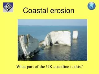
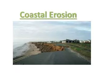
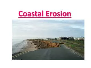
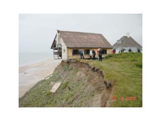
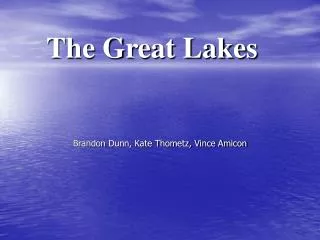
The ICAN Coastal Erosion Use Case as a Model for Wisconsin and the Great Lakes. David Hart GIS Specialist University of Wisconsin Sea Grant Institute ICAN – Great Lakes Madison, Wisconsin September 14, 2010. Coastal Erosion Risks. Southern Ozaukee County, 2007

E N D
The ICAN Coastal Erosion Use Caseas a Model forWisconsin and the Great Lakes David Hart GIS Specialist University of Wisconsin Sea Grant Institute ICAN – Great Lakes Madison, Wisconsin September 14, 2010
Coastal Erosion Risks Southern Ozaukee County, 2007 Source: David Mickelson, Lou Maher
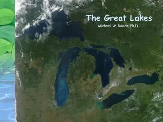
Coastal Flooding Risks Oconto County, 2007 Source: David Mickelson, Lou Maher
Canal Park, Duluth, MN, November 26, 2001 Source: http://www.glerl.noaa.gov/seagrant/glwlphotos/Seiche/26November2001/26November2001.html
WCMP Coastal Hazards Work Group • Work Group formed in the early 1990s • Damages from 1985-6 high lake levels • Needs Assessment and Multi-year Strategy process. • Membership • Wisconsin Coastal Management Program • Wisconsin Department of Natural Resources • Wisconsin Emergency Management • UW Sea Grant (coastal engineer, GIS specialist) • UW-Madison – Civil Engineering, Geology
WCMP Coastal Hazards Work Group • CHWG 2006-10 Work Plan • Expansion of technical tools and technology transfer • Education and outreach • Coordination with municipalities and agencies • Projects (CZMA Section 309 Enhancement Funds) • Lake Superior bluff/wave studies (Wu, Mickelson) • Oblique photos/shore structure analysis (Mickelson) • Erosion setback methodology (Lulloff, Keillor) • Hazard mitigation planning guide (Bay-Lake RPC) • Bayfield County setback ordinance (Kastrosky, Mickelson) • Lake Michigan lakebed downcutting (Wu) • Coastal Example Ordinances – Sea Grant Law Center (Ohm)
Wisconsin Coastal Atlas • Goal 1: The WCA will serve as the portal to geospatial data for the Great Lakes coasts of Wisconsin • Goal 2: The WCA will promote the development of a spatial data infrastructure for the Great Lakes coasts of Wisconsin through methods for cataloging, archiving, and semantic integration • Initial focus on implementing the maps and search components for coastal hazards • Synchronized with a two-year NOAA Coastal Management Fellow who will help build a Great Lakes spatial decision support toolbox for hazards resilience and comprehensive plan implementation
ICAN Coastal Erosion Use Case • Role/Client - Coastal Manager Uses an inventory to take regulatory action; helps form policy guidelines as potential statutes or regulatory rules • What are the erosion rates along a geographically defined shoreline reach? • Where/When/How has the shoreline been protected? • Where is the socioeconomic infrastructure at greatest risk due to coastal erosion? • Where is the potential for habitat loss due to coastal erosion a significant risk? • Other Roles – Private Property Owners, Emergency Responders, Scientists, Local System Administrators
Key Datasets for Coastal Erosion Bluff and dune fields Regulatory jurisdictions Community development Geomorphology profiles Erosion Risk study results – Risk Zones or Lines Topography Wave climate data Shallow water bathymetry Transportation networks Public utilities Public lands • Coastal access and recreation • Coastal armoring • Cadastral datasets with assessor attribution • Geology • Land use and zoning • Current shoreline position • Historic shoreline positions • Permit tracking systems and a dynamic link to cadastral data • Aerial imagery • Streams • Beaches
Coastal Hazards Studies/Policies/Data Bluff Recession Studies Shore Recession Studies Lakebed Erosion Studies Bluff Stability Studies Flood Studies Wave Studies NR 115 - State Setback Ordinances - Local Oblique Photos Chapter 30 - State Stormwater Ordinances - Local Webcams GL Restoration Strategy Hazard Mitigation Plans Animations GL Compact Comprehensive Plans Panoramas Orthophotos Satellite Imagery Soils - NRCS Shoreline - Local Topography – DEM Parcels Shoreline - DNR Topography – Contour Mapping Planimetric Mapping Shoreline - NOAA Bathymetry – Hydro Surveys Infrastructure Mapping Flood Maps - FEMA Bathymetry – LIDAR Hydrography – Local Benthic Structure Coastal Terrain Model - Bathy/Topo Land Use/Land Cover
Wisconsin Coastal Atlas – SDI Objectives • Objective 4 – Develop and implement a CWA geospatial data catalog with concurrent archiving capabilities. • data catalog developed specifically for Great Lakes coastal issues (start with coastal hazards) • document technical and institutional barriers to the development of a spatial data catalog of current and historic coastal data • robust data archiving procedure to manage data sets over time • work with coastal hazards stakeholders to promote the use of catalog open access and data archiving procedures Advance the development of domain spatial data infrastructures. Development of effective methods for archive of digital geospatial data will help resolve a critical problem facing data custodians.
Wisconsin Coastal Atlas – SDI Objectives • Objective 5 – Develop ontologies for coastal hazards in Wisconsin to promote semantic integration • Develop and conduct two spatial queries to test semantic interoperability for the entire the Great Lakes coasts of Wisconsin using data from local partners as it resides in the geospatial catalog • calculate the assessed value of land and improvements of coastal parcels • calculate current land use by general zoning categories within the 1000 foot shoreland zoning jurisdiction for the Great Lakes
Coastal Atlases and the Coastal Erosion (and other) Use Cases – Lake Erie • Examined four Coastal Atlases/Conservation Authority web mapping sites on Lake Erie related to whether questions in the ICAN coastal erosion use case could be answered. • That wasn’t possible, but explored environmentally sensitive areas and locations of dams in coastal watersheds. • Ohio Coastal Atlas (http://www.ohiodnr.com/LakeErie/Maps/tabid/19562/Default.aspx) • New York – Ocean and Great Lakes Atlas (http://nyoglatlas.org/index.cfm?&userSkin=4) • Essex Region Conservation Authority (http://niobe.countyofessex.on.ca/imf/sites/c_essex_erca/jsp/launch.jsp) • Grand River Conservation Authority (http://www.grandriver.ca/index/document.cfm?Sec=63&Sub1=0&sub2=0)
Location of Environmentally Sensitive Areas • Coastal barrier resources • Conservation areas; wildlife refuges • Biota • shellfish • invasive species • bird concentrations • significant coastal fish and wildlife habitats
Watersheds • Dams Dams in Coastal Watersheds