Download
1 / 17
170 likes | 369 Views
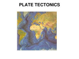
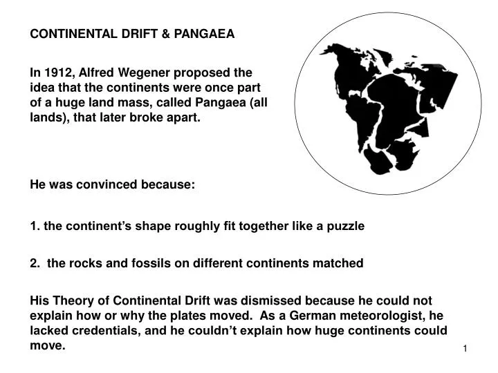
CONTINENTAL DRIFT & PANGAEA. In 1912, Alfred Wegener proposed the idea that the continents were once part of a huge land mass, called Pangaea (all lands), that later broke apart. He was convinced because:. 1. the continent’s shape roughly fit together like a puzzle.

E N D
CONTINENTAL DRIFT & PANGAEA In 1912, Alfred Wegener proposed the idea that the continents were once part of a huge land mass, called Pangaea (all lands), that later broke apart. He was convinced because: 1. the continent’s shape roughly fit together like a puzzle 2. the rocks and fossils on different continents matched His Theory of Continental Drift was dismissed because he could not explain how or why the plates moved. As a German meteorologist, he lacked credentials, and he couldn’t explain how huge continents could move.
NOAA In the early ’60’s, Harry Hess and J. Wilson, proposed a mechanism for continental movement, which eventually became known as seafloor spreading 1969 - The Glomar Challenger drilled a series of holes in the Mid-Atlantic ridge. What they found revolutionized geology and oceanography!
Continental rocks date the Earth at about 4.6 billion years old. Since the ocean floor is lower in the lithosphere, scientists expected to find older rocks at those depths. Continental geology’s Law of Superposition states that oldest rocks are laid down first and should be found horizontally lowest in a bed unless uplifted.
Instead, they found no rock older than 200 million years old and most were much younger. How could the ocean floor be younger than the continents riding on it? The Deep Sea Drilling Project showed that rocks became older as they moved away from the MOR. Oceanic geology showed rock layers are created vertically - not according to the Law of Superposition.
The MOR seemed to be a parallel distance from continents on either side. Core samples revealed matching magnetic striping in rocks on both sides of MOR. In 1977, Project FAMOUS, using Alvin, photographed magma squeezing out of the MOR and creating new ocean floor. Scientists, Vine and Matthews, now had the data for a cohesive theory on plate tectonics. The sea floor was spreading - moving the continents with it. The theory of sea floor spreading explained continental drift. Wegener was right.
PLATE TECTONICS - TO BUILD Earth’s lithospheric crust: - is divided into large and small plates - makes up the ocean crust AND the continental crust, along with the upper mantle The oceanic crust averages 5 km (3 mi) thick The continental crust averages 20-50 km (12-30 mi) thick Both are relatively thin
The crust covers a thick, molten, moving mantle (68% of Earth’s volume) and a heavy core, possibly composed of nickel and iron. Convection currents in the asthenosphere (upper portion of mantle) move the lithospheric plates in a manner similar to a conveyor belt Convection Currents The plates are moving in different directions further cracking the crust The Earth from the Moon.
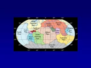
By looking at seismic and volcanic activity around the world, scientists can identify the plate boundaries.
These are the major plates: North American, South American, Pacific, Eurasian, African, Nazca, Indo-Australian, and the Antarctic plate.
MORE EVIDENCE FOR PLATE TECTONICS Pattern of reverse & normal polarity in ocean floor rocks As seafloor cools – the minerals in the magma align with the current magnetic field Bands of seafloor rock alternating between normal and reverse polarity parallel MORs and are mirror images of each other
MORE EVIDENCE FOR PLATE MOVEMENT Oldest continental crust is 4.6 billion years old Oldest oceanic crust is 200 million years old and gets older away from MOR Why the difference? New seafloor is created at MORs and destroyed at trenches
MORE EVIDENCE FOR PLATE MOVEMENT HOT SPOTS Plumes of molten rock well up from deep within the mantle and forces its way up through the lithosphere to erupt in a volcano The plate moves over the hot spot creating a new volcanic island As the plate moves, old volcanoes are eroded, new volcanoes form
FOUR TYPES OF PLATE BOUNDARIES 1. Oceanic-Oceanic Boundary - divergent, meaning to move apart a. both plates are composed of basalt - the primary type of ocean floor rock (iron, magnesium and silicon ) b. both plates have the same higher density rock c. the result is a spreading center where new ocean floor is created ex: Mid-Ocean Ridge (MOR) This same ridge is 40,000 miles long and is found in many places in addition to the middle of the Atlantic Ocean.
2. Continental-Continental Boundary - divergent, meaning to move apart a. both plates are granitic - a type of igneous rock b. plates have the same lower density rocks c. The result is that continent is pulled apart and a rift valley forms – eventually becoming a new ocean ex: East Africa Rift Zone NASA
3. Continental-Continental Boundary - convergent, meaning to come together a. both plates are granitic - a type of igneous rock that is the basis of the rock cycle (silicon and aluminum) b. plates have the same lower density rocks c. The result is that edges are forced up into mountains. ex: Himalayas, Atlas Mountains NASA
4. Oceanic-Continental or Oceanic-Oceanic Boundary - a subduction zone where one plate overrides and the other is forced down into the mantle (convergent) a. lighter continental plate or oceanic plate overrides the denser oceanic plate b. oceanic plate edge is subducted down into the asthenosphere and remelted c. The result is a trench ex: Peru/Chile Trench USGS Chile Trench